Subscribe to receive top agriculture news
Be informed daily with these free e-newsletters

Vegetation health index images show the effects of early planting and maturity, but they also raise questions about the health of this year’s crops.
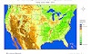
Farm Futures has partnered with the Ecology and Agriculture Spatial Analysis Laboratory (EASAL) at Kansas State University to bring these vegetative health index maps to you. Each map is composed from satellite data taken over a two-week period. The EASAL maps show current vegetative health for the past two weeks and compare vegetative health with the previous two-week period, with the previous year and with the long-term average. Green reflects healthy vegetative development, while brown reflects a lack of healthy vegetative biomass production.

Satellite imagery shows active vegetative growth on the West Coast and in many areas of the eastern half of the Lower 48 states. The corn crop is far enough along now to begin filling in prime growing areas of the Midwest now as well, covering soils that previously showed up on the imagery in these areas.

Drought conditions have combined with the early harvest of this year’s winter wheat crop to show very little photosynthetic activity in the central and southern Plains relative to the long-term average for early June. Traders should also be concerned about the lack of vegetative growth in the Northern Plains relative to normal for early June, although some of that is likely reflective of a shift in acreage from spring wheat to summer row crops this year. Meanwhile, vegetative growth is above normal in northwestern Iowa and central Illinois.

Crop health responded positively to recent rains in northwestern Iowa over the past couple of weeks, while deteriorating in scattered areas across much of the South.

Vegetative activity is well ahead of the previous year’s levels in eastern Nebraska, Iowa, Illinois, Indiana and southwestern Ohio. Much of this is simply due to the quicker planting and establishment of the crops this year. However, it is also easy to see from the satellite imagery that vegetative activity is well-below the previous year’s levels in Kansas, Oklahoma, Texas, Missouri and Arkansas due to the advanced maturity of the wheat crop and heat and dryness in the region. Spring crops are planted earlier and on more acres in the Northern Plains, show up as greater vegetative activity, but the advanced maturity of the spring wheat crop is also beginning to show up on satellite pictures.

This graphic shows the long-term average vegetative health for this time of year.
You May Also Like
Enter a zip code to see the weather conditions for a different location.


