

Subscribe to receive top agriculture news
Be informed daily with these free e-newsletters

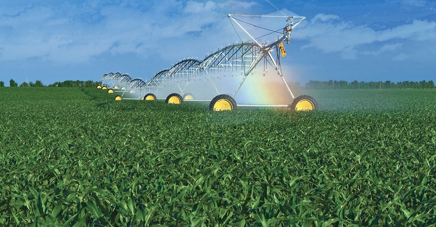
An agronomist monitoring potato fields uses aerial thermal imaging to spot irrigation problems.
John Vaadeland, a Park Rapids, Minn., agronomist who monitors potato fields in North Dakota and Minnesota, is spotting problems in potato fields long before he can see the symptoms with the naked eye. He accomplishes this by using a new multi-spectral aerial imaging service from Ceres Imaging.
Ceres, a California-based company, provides aerial multi-spectral images that can show water, fertilizer, pest and disease issues. It processes and delivers the images to customers within 24-72 hours of flying the field, so the images can be used to correct problems before yield is lost. Ceres has been providing the service in Australia, Hawaii and California orchards and vineyards for years, and has recently expanded into corn and high-value crops in the Midwest.
Last year, Vaadeland ordered a half dozen flights and a series of images of the potato fields he monitors in southeast and north central North Dakota and central Minnesota.
High-resolution thermal images taken from a low-flying airplane showed differences in plant canopy temperatures, which revealed several unexpected problems. In one field, there were curious rings that indicated a variation in plant vigor. It turned out some of the pivot’s J-drop pipes were corroded and partially clogged, which reduced the water flow to several sprinkler heads. The plants underneath those heads weren’t getting enough water.
In a couple of other fields, new sprinkler packages had been installed improperly and plants were being over and underwatered.
“We were able to correct those problems right away,” Vaadeland says.
All the fields showed streaking, which at first appeared to be related to the fertilizer application. But upon closer observation, it was determined that poor plant spacing was the culprit. Having the images helped justify the decision to buy new planters.
Ceres charges $8-$14 per acre for its service, depending on the number of flights per year and the different types of images produced from each run.
Vaadeland got a special introductory rate because it was Ceres’ first experience with potatoes and he helped them with the analysis.
“It was well worth it,” he says of the images.
Vaadeland ordered more flights and photos from Ceres this year. He had Ceres start taking images earlier in the season, too.
Vaadeland see more potential uses for the technology. One day, he’d like to be able to use aerial images to help determine when to start and stop the irrigators, something Ceres is now trying to do for orchards and vineyards.
Having soil moisture level data from a whole field would be a lot better than just having readings from a small area around several soil sensors, Vaadeland says.
Ceres Imaging answered a few questions about its services:
How do you capture images? Do you use drones?
We do NOT use drones. When Ceres Imaging first started, we experimented with drones and found that they could not cover the area that an aircraft could in the same amount of time. Drones are not able to withstand much of a payload capacity, which is needed for our camera systems. Additionally, more personnel would be needed in the field to maintain and move drones from site to site.
When do you fly over the fields?
We primarily fly fields in a four-hour window centered on solar noon. During this time, the sun is at its highest and the orchard is under the most stress, which assures high-quality imagery.
What is the imagery resolution?
Our resolution is 0.2 — 1 meter per pixel, depending on the crop and application.
What light wavelengths do your cameras use?
Our cameras take images at multiple wavelengths ranging from the visible to the far infrared light spectrum. Depending on the kind of imagery package you request, we can take up to six different wavelengths of the light spectrum at once.
How many images are taken in a typical 160-acre field?
Our systems capture hundreds of images, and the individual frames are processed to make a seamless mosaic of your field.
What imagery packages do you offer?
We tailor our imagery packages to fit your needs. Our packages include weekly, monthly and custom options. We offer a Chlorophyll Imagery package, which is good for influencing nutrient decisions. The image can be used for precision tissue sampling and precision fertilizer applications.
After I get the images, then what?
After we have processed and delivered your imagery, our staff will help you by pinpointing issues that may be detected in your images. We have a team of imagery specialists and agronomists to evaluate what might be happening in your fields. They have the experience to identify any issues that stand out. They will mark locations of interest and provide an explanation. If further ground truthing is required, we will send our agronomists in the field to try and identify the issue and come up with a remedy. You can always call or email our specialists anytime to answer your questions. At the end of the year, we can also provide a return on investment to show you that we are an asset.
You May Also Like
Enter a zip code to see the weather conditions for a different location.


