

Subscribe to receive top agriculture news
Be informed daily with these free e-newsletters

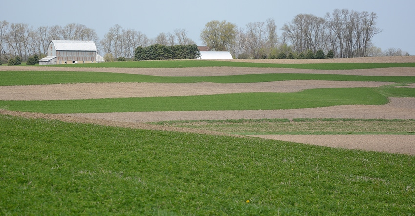
Ag Water Stewardship: Topography, soils and climate help determine how land can be managed.
December 27, 2017
The concept of precision farming is probably familiar to you.
Some aspects of precision are present on virtually all farms, employing a wide range of technology. The twin to precision farming is precision conservation, and you are probably using it as well.
Precision agriculture is often described as managing inputs at a finer scale in order to provide more precise levels of nutrients, such as applying different nitrogen rates to different fields, or even different areas within fields, rather than applying the same rate across the whole farm. Variable-rate nutrient applications have been shown to improve nutrient use efficiency, which also reduces environmental impacts.
Variable tillage is another example of precision farming that also provides precision conservation. Keep in mind that it wasn’t many generations ago that on any given farm, most acres were moldboard-plowed each year. Application of crop protection products only when threat thresholds are met also helps improve efficiency, sustainability and environmental performance.
In the previous examples, precision conservation is similar to precision farming in that specific practices are applied in specific places on cropland. There are precision conservation practices that are not necessarily related to farmed acres, but are also very important in addressing environmental risk factors.
CRP very popular
The Conservation Reserve Program, which allows marginal lands to be retired for an extended period of time, has been a popular program in Minnesota. Over time, it has become more effectively targeted toward the most sensitive lands. Alarmist claims that CRP acres will disappear are offset by the fact that more than 1 million acres of cropland is enrolled in the program. Landowner demand continues to outpace program capacity, suggesting an ongoing need to prioritize and get the most sensitive lands enrolled. Precision ag tools, specifically yield maps, often help with this prioritization.
Terraces, grass waterways and filter strips address water erosion, and naturally, their placement requires a level of precision. Tree rows, cover crops or reduced tillage fit for those areas prone to wind erosion. Some landowners use agency programs and technical assistance to install these practices, while others install them on their own. Either way, both precision conservation and precision farming work together.
Some farmland has no crops
The choices of crops and where they are grown is a form of precision conservation often overlooked. Topography, soil characteristics and climate all play a role in cropping decisions that is still being fine-tuned after more than 150 years. The very most sensitive lands were often recognized, even in the early years of statehood, and served as pasture. Over the years, some of those acres have been cropped, too. Today, only about 20 million acres of the 26 million acres that make up “farmland” in Minnesota are cropped.
The buffer conservation of the past couple of years serves as a good example, as many of the near-stream areas, especially in the steeper regions of the state, have long been buffered simply because they were unsuitable for crop production.
So I guess to some extent, precision conservation has been around for a long time.
Formo is executive director of the Minnesota Agricultural Water Resource Center.
You May Also Like
Enter a zip code to see the weather conditions for a different location.


