Subscribe to receive top agriculture news
Be informed daily with these free e-newsletters

Imagine viewing a 3-D map of your vineyard and then zooming in and navigating through the vineyard to get a closer look at one particular location in the field were the vines appear stressed for water or for a time-lapse look at how the clusters have developed over the past few weeks.
Such a virtual vineyard, of course, isn’t the same as actually monitoring and examining the vines and fruit in person. But, it could be the next best thing, says Ali Pourreza, a University of California Cooperative Extension agricultural engineer based at the Kearney Agricultural Research & Extension Center, Parlier, Calif.
What’s more, he adds, it offers the promise of allowing you to assess conditions throughout your vineyard without the time and expense of walking up and down each and every row.

In fact, you can already do this using Lidar (Light Detection And Ranging or Light Imaging, Detection, And Ranging), an optical airborne remote sensing technology that uses a pulsed laser to measure natural and manmade features on the earth’s surface and creates a highly accurate digital 3-D point cloud representation of the target.
There is a catch, however: The laser, scanner and specialized GPS receiver required for such a system can cost upwards of $100,000.
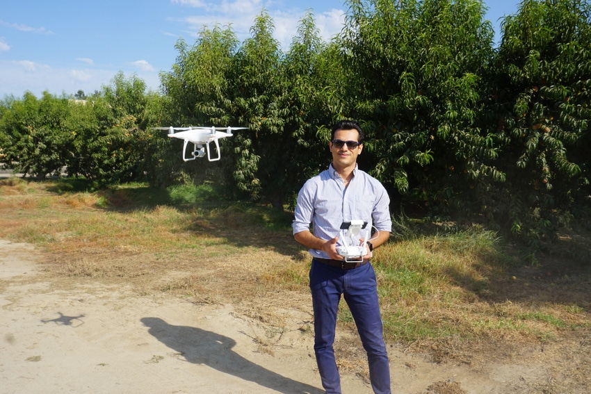
Pourreza is working to develop a much more affordable way of combining aerial digital images, taken by a drone, with computer technology that would allow you to create a virtual three-dimensional reconstruction of your own vineyard. It could also be used for a fruit or tree nut orchard.
The goal is to help growers make better decisions in managing their vineyards by arming them with more timely, more accurate information about the conditions throughout their fields, Pourreza says.

He’s using a camera-equipped drone, flying over a vineyard at altitudes up to 400 feet above the ground and in two perpendicular courses, to take overlapping digital images of the vines from different sides. A computerized flight-mission planning app allows him to program the location, height and angle at which the images are taken and provide views underneath much of the canopy.
Computer software assembles the images, as many as 10 of any one feature or point in the vineyard, into a point cloud representation which can be further analyzed to make measurements such as vine geometry, volume and density.
This technology allows him to photograph or map a 160-acre vineyard in about 1½ to 2 hours of flying time depending on the flight altitude, he notes.

The aerial images can be captured by a regular color camera to generate a virtual vineyard in the visible light band. However, rather than creating the virtual vineyard in visible range, it can be generated by multispectral images in non-visible bands such as near-infrared (NIR) or red edge bands that include information about such vineyard features as water stress, nitrogen demand and chlorophyll content.
An animated video of a virtual vineyard created by Pourreza is available at https://youtu.be/2Pgj1qHxtw8
Although his work is still in the early stages, Pourreza envisions a number of ways in which growers could use a virtual vineyard to produce a crop more efficiently and more profitably.
For example, the images can show the amount of shading beneath the vine canopy. Currently, he’s working with UC crop water specialists to correlate this information with Et (evapotranspiration) to identify the site-specific water demand in the vineyard. Irrigation rates and frequency could then be adjusted accordingly.
Nutrient management is another likely application, Pourreza notes. Because the amount of biomass relates to the level of nitrogen required for the vines, using a virtual vineyard to measure canopy volume could be used to adjust nitrogen fertilizer application rates where needed in the vineyard.

A series of fly-overs on an appropriate schedule could be used to create a time-lapse record of changes in part of all of the vineyard through the season, such as progression of the bloom, growth of the canopy and development of the crop load.
“Because this virtual vineyard technology can provide detailed site-specific information from throughout the vineyard, it would be ideal for precision viticulture practices,” Pourreza says. “The information in these images could be used to produce prescription maps for variable rate applications of nutrients, fungicides and insecticides to apply the material only where and in the exact amount needed to minimize production costs and better protect the environment.”
These are only a few of the opportunities such technology offers growers, he says. Pourreza wants to collaborate with a wide range of UC researchers – viticulturists, soil and plant scientists, plant pathologists, entomologists, weed scientists and irrigation specialists – to identify, extract and interpret the wealth of information provided by these airborne digital images.
“We’re just at the beginning of using virtual technology to improve vineyard management practices,” he says.
You May Also Like
Enter a zip code to see the weather conditions for a different location.


