

Subscribe to receive top agriculture news
Be informed daily with these free e-newsletters

• Not only would scouting crops be quicker with drones, but it would be potentially much more efficient, because they would provide a bird’s eye view of different areas of a field where stress points in a crop are likely to be found.
October 21, 2013
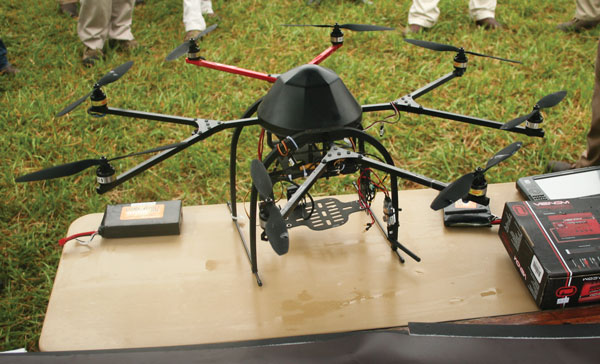
On a late summer day in the southeast corner of Virginia passersby got a brief glimpse of agriculture in the future, as researchers from Virginia Tech University and the University of Florida mapped a soybean field using a low-flying drone, equipped with high tech cameras.
The test run was repeated the following day at the Virginia Ag Expo, held at the Fields of Hope Farm near Virginia Beach.
The combination of high resolution pictures from the previous days’ flight and a close up look at the drone piqued the interest of numerous farmers and crop consultants.
Virginia Tech Scientist Jim Owen says technology for the small, battery-powered aircraft has come a long way in the past couple of years, but regulations for their use remains a little cloudy at best.
“Right now, as we understand FAA (Federal Aeronautical Administration) rules, if you are flying this aircraft on your property, you can be classified as a ‘hobbyist’, which require no Federal license,” Owen says.
“However, if you are flying the drone for profit and flying it over someone else’s land, you have to have permission to be there and an FAA license, something akin to a pilot’s license,” he explains.
“Therein lies a potential limitation to the practical use of these machines for agriculture. The most likely use of a scout drone is by crop scouts or agricultural consultants. And, as we understand the law right now, that require an FAA license,” the Virginia Tech researcher says.
Uses of the drones are virtually limitless.
In about 30 minutes, Owen and his colleagues set up flight points, flew the drone and mapped a 100 acre or so field of soybeans at the Virginia Ag Expo site.
Clearly, this could be a huge timesaver for crop consultants and could make their job more efficient and timely.
No longer would a consultant have to drive through and around a large field, stopping frequently to check for stress points such as disease, insect or weed pressure.
Not only would their scouting be quicker, but potentially much more efficient, because they would have a bird’s eye view of different areas of a field where they are likely to find stress points in a crop.
(You might also like Unmanned helicopter puts farming up in the air. Other useful information can be found at Unmanned aerial vehicles have bright future in precision farming).
Operation of the Virginia Tech drone is simple. It runs off a single RC battery, which requires frequent charging. The length of the flight is limited by the weight of the battery that powers it.
The drone flown at the Virginia Ag Expo can stay in the air about 15 minutes. The drone can be quickly landed, new batteries attached and be airborne in a few seconds.
Flight points are programmed into the computer guidance system and the drone then flies on auto pilot. The pilot who flies the drone essentially has to take off and land the machine.
The camera mount on the drone is gyro-balanced using a GPS system that keeps it perpendicular to the ground, regardless of the movement of the aircraft.
The high resolution cameras take video, which can be broken down frame by frame into high resolution photographs.
The drone typically flies at about 300 feet or lower. This allows it to take high resolutions pictures as the aircraft hovers over pre-set areas of a field. It also keeps the small aircraft out of the way of other manned aircraft that must legally fly at least 500 feet above the ground.
Though the drone has a range of about one mile from the controller, the Virginia Tech researchers set the range at 250 meters, or about 275 yards.
“The drone is highly stable, and even if you take your hands off the controller, the GPS system will hold the drone in a hover position, until you tell it what to do, or it runs out of battery power,” Owen says.
Keeping the $10,000 drone closer than a mile, he adds, makes it much easier to be sure it gets up and down safely and without damage.
Initially, at least, the most practical use for farmers will be to detect stress, regardless of the its cause. Growers can look at things like drainage, cover crops and various field conditions without actually getting into a field.
With all the rainfall this year, having that capability would have been a big help throughout much of the Southeast for much of the growing season.
In addition to the questions about licensing for flying one of these drones, another restriction for growers may be the cost, which can push $50,000. However, the cost is likely to come down, as is the case with most new technology.
And, there are plans in the works to have an online written test to acquire a license to fly a drone for crop scouting.
“Right now, I would say scouts are likely to be the first to put these drones into practical use. In the future, larger farming operations may have their own drones, but it’s likely that most will still rely on scouts to fly the planes, download the information they obtain and use that information to help growers put together farm plans,” Owen says.
The concept of using unmanned aircraft for agriculture isn’t something new. Unmanned aircraft have been used to spray crops in Japan for at least a decade and in parts of Australia for nearly that long.
The use of drones in agriculture is bolstered by the continued proliferation of farm size and the corresponding reduction in numbers of farmers.
No longer can a large acreage farmer know much about what is going in every one of their fields, Drones could change all that.
One possible application is to pin-point early damage to crops, giving growers a head start on correcting stress related problems, like early insect outbreaks or a disease occurring at an unusual time of the growing season.
Stress can be easily detected by low-flying drones using infra-red and near infra-red cameras. The same concept is used by a number of ground devices, like GreenSeeker.
Early signs of plant damage show up in chlorophyll, the energy-making factory for plants, which could be captured in drone airplane imagery.
Drones are also a potentially major component of the expanding Green Industry in agriculture.
More precise imagery could also allow farmers to tie aerial imagery to GPS guided sprayers and better target pesticides just to the plants that need them, reducing how much ends up in the environment or even our food and water supply.
Drones are the most likely vehicles to acquire remote sensing information that companies like DuPont Pioneer are promoting.
A recent corporate release from DuPont Pioneer defines remote sensing as “collecting information about objects (e.g., soil or crop surfaces) from remote platforms like satellites, aircraft or ground-based booms.”
“Remote sensing involves the collection and analysis of reflected light and is a potentially important source of data for making site-specific crop management decisions,” says John Shanahan, DuPont Pioneer agronomy research manager.
He adds that remote sensing tools can provide information not only about spatial variability within fields, but also changes in crop conditions throughout the growing season.
This year DuPont Pioneer is providing remote sensing imagery services to growers though Pioneer Field 360 services.
Images in this program can be used to develop management zone-directed soil samplingschemes, validating hybrid tests or evaluating other agronomic practices on your farm. Imagery does not replace the need for crop scouting. Instead, it directs growers to areas of the field that require ground evaluation.
You May Also Like
Current Conditions for
57°F
Mostly Cloudy
Day 54º
Night 46º
Enter a zip code to see the weather conditions for a different location.


