March 4, 2021

There’s no doubt that the last year has changed the way farmers interact with dealers and technology. And that greater interaction is guiding development of the tech tools producers use. For example, The Climate Corporation has announced software upgrades designed to boost productivity and ease of use.
Kyle King, commercial product director, Climate Corp., talked with Farm Progress about those changes and what they mean. But he started by sharing how COVID-19 has impacted use of the company’s tech tools.
“We’ve seen an uptick in remote view,” King says. “Farmers are allowing their trusted advisers to be able to kind of see what they're doing. Whether it’s planting activities, application activities, harvest activities — it’s almost like they’re sitting in the cab with them.”
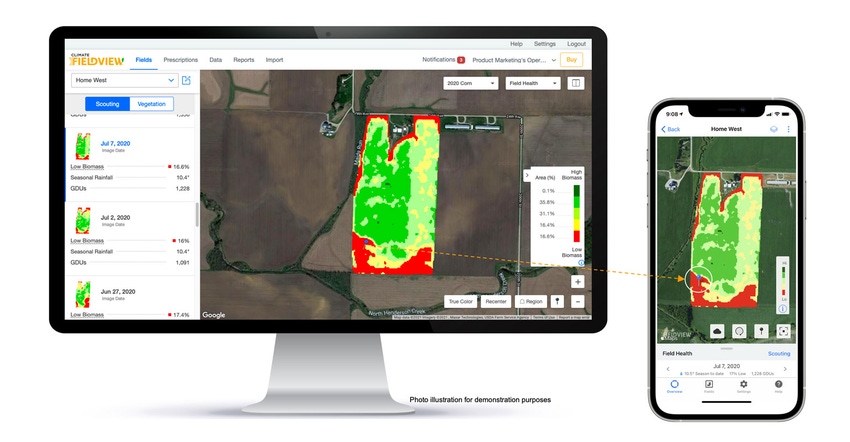
In addition, King says more farmers are using the imagery tools available on Climate FieldView for scouting. A farmer can drop a scouting pin on a map for his or her use, or share with the adviser to check out that portion of the field.
And in 2020, a lot of that work was “app-based,” requiring a smartphone or tablet to get the job done. Yet when it came time to sit down and analyze information, farmers wanted more. “We were getting feedback from customers and business partners telling us they love using their phone or tablet, but ‘When I'm sitting down doing planning and data, I do that on my desktop.’ They wanted more,” King notes.
The key was to have the information collected on the app available in the cloud for use with the Climate.com account. King says farmers wanted to take the information they’ve been collecting and drill deeper for planning.
Managing information 2021
“Our work for 2021 is really around making it easy for a farmer to collect data, digitize their data — and most importantly, do something with it,” King says.
Pins on field maps and notes in the app are great in-season, but what’s the next step? The key was to drive information collected into the decision-making process. And new for 2021 is the Field Region Report functionality on the web. The service has been available on tablets and smartphones.
“You know that for a long time, we’ve always looked at results and performance in aggregate at the field or farm level,” King says. “With our Field Region Report, you can get down to the sub-field level and clearly understand how a hybrid or variety performs.”
Farmers can “circle” areas of interest in FieldView maps on the desktop, and then save these areas as regions with notes or photos from in-field visits. For that field section, you have seeding rates, soil type, fertilizer application and other data for analyzing what’s happening in that field.
King explains that with that information, you can identify how different factors impact yield and profit on the farm. “It’s just a really great way to ask your data questions, to get results and quantify what you did,” he says. “And if you’re making decisions for next year, you can really dig down deep on each field.”
Moving these tools to the desktop environment, beyond the app, helps make the work easier. King notes that farmers sitting at their computer won’t need to look at their smartphone or tablet to find what they need. It will all be in their Climate.com account.
Enhancing usability
The Climate.com account gets more powerful for 2021 with enhanced scouting features. You can view or create scouting pins and notes across all devices. If you find something when scouting with your smartphone and drop a pin, when you return to the office later you can see that on the desktop. That added scouting flexibility not only saves time, but also make information access easier.
Beyond “dropping a pin,” King notes farmers can look at imagery and perhaps spot trouble before heading to the field. Or they can share the information with an agronomist who scouts those fields. “You can drop a pin and now geo-reference the information and share it,” he notes. “And you have it documented across all your devices. It’s a great way to connect, document and gather information virtually.”
And those pin drops can have more value than finding crop trouble. They can be used to pinpoint field features like tile inlets (valuable for field operations), and other features. These can help avoid trouble.
Finally, the user experience has changed to simplify finding information. King explains with the advanced search/filter, you can find fields quickly; and for farms with multiple fields, the days of scrolling field names to find the right location are ending.
The user experience now allows you to visualize fields grouped by farm. That can save time for both the farmer, and that trusted adviser.
For more information, visit climate.com.
About the Author(s)
You May Also Like


