November 4, 2020

Satellite imagery can be a great tool for crop management, and the advent of daily images has been more helpful to agronomists, too.
One satellite image company, Planet, is introducing new technology that could offer those scouts even more advanced information — in part by getting rid of the clouds.
Note that Planet doesn’t sell to farmers, but provides imagery for other firms to make available to agriculture. Granular and Farmers Edge are both using Planet imagery.
Recently, Planet announced several innovations to be made available to partners, if they want to take advantage of it. For agriculture, the new Planet Fusion product could be a game-changer. It uses machine learning to combine Planet images with public sources to provide cloud free daily imagery.
“We’re using machine learning and those public datasets to bring the best of that data all into a single new product,” says Jim Thomason, vice president of imagery products, Planet.
Essentially, the combination of daily images with a rich database of public satellite imagery enables the Planet Fusion product to provide reliable, clean images.
Thomason explains that the Fusion product is built on the company’s vast image database. “We’ve been imaging every day for years, and we have this very deep archive of imagery,” he says. “We also have access to all the public mission archives as well.”
He notes that with that stack of data, it’s possible to train the model to use the Planet image and mesh data from public sources including Sentinel, Landsat, MODIS (Moderate Resolution Imaging Spectroradiometer) and VIIRS (Visible Imaging Infrared Radiometer Suite) to provide gap-free imagery. So, the days of clouds messing up that imagery are over if you have access to the Planet Fusion imagery.
More than eyes in the sky
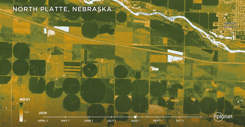
Thomason says that the work to develop the Fusion product involved more than capturing different satellite image data. “We've been investing quite a bit in ground-truth using in situ sensors sitting in fields to measure NDVI [Normalized Difference Vegetation Index], for example, and overlaying that with populated NDVI captured from our satellites,” he says. NDVI measures the state of plant health based on how a plant reflects certain frequencies of light.
“We’ve been very happy with the results so far, and that’s why we went public with this. We’ve been testing it and making sure that it is predictable and precise enough,” Thomason says.
He adds that new satellites the company has launched can also see a better — or, rather, a wider — range of light spectrum. This information has value for evaluating crop health and productivity, too. “The other exciting news, in my opinion, would be some of the new spectral bands that are coming online,” he says. “We’re able to look at red edge and the second green band, and using that kind of spectral richness that our ag customers are using will unlock new insights.”
Added spectrum provides enhanced crop health information that can be used for in-season action. Planet made a significant investment in these new spectra with the launch of 26 satellites earlier this year.
Expanded data use
Ariel Zajdband, product subject matter expert for agriculture at Planet, notes that with Fusion and the added spectrum, there will be advanced information on crop health and yield. This may offer enhanced insights and information for a business area gaining traction in agriculture — outcome-based pricing.
While still in trial with some companies, added satellite data could play a role. “We know that some companies are working toward an outcome-based pricing model,” he says. “This kind of information would be very important if working with that model. The information could also help provide more information about fertilizer recommendations, and it will help with yield estimation models.”
Better data would offer enhanced information for knowing crop yields in greater detail ahead of harvest, which can be a valuable risk management tool. For outcome-based pricing, verifying on-farm information is an important component.
Satellite imagery is getting more precise. Add in machine learning and a wider band for image capture, and the value of the information rises, too. While Planet doesn’t sell directly to farmers, you can learn more about the tools and technologies available by visiting planet.com.
About the Author(s)
You May Also Like


