September 6, 2016
Think Different
Wade Barnes, Farmers Edge CEO, recommends four steps to evaluate remote sensing services:
Become more data aware by trying entry level services (often free or low-cost)
Use data to make actionable decisions
Measure results to identify actual return on investment (ROI)
Sign up for more services, more data and greater ROI
___________________________________________________________________________________________________
To prove his stewardship and get a handle on a rapidly developing technology are two good reasons North Dakota farmer Jon Bertsch works with remote sensing tools. However, the main reason he gets daily rain reports, satellite images, crop health alerts and variable rate seed and nitrogen prescriptions is that they help him better manage his 3,000 acres largely devoted to corn and soybeans.
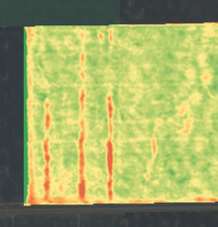 "This year we had a hail storm come through," recalls Bertsch, who farms in the Red River Valley, west of Grand Forks.
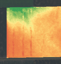 "The satellite imagery told us where the hail pockets were, and we showed adjustors in the field on our iPad. We could show before and after storm images of what couldn't be seen from the road. It was amazing to see the change in the vegetation."
Value of agronomist and remote sensing
In 2015, changes in vegetative color signaled aphid hot spots. "Changes didn't tell me what was going on, but they did say an issue was developing and where," he says.
Bertsch relies on FarmLogs for his remote imagery and shares them with his agronomist. In the case of the aphids, the agronomist went to the hotspots, ground truthed the problem and recommended control based on in-field counts. He sees both agronomist and FarmLogs as valuable resources.
"Some people suggest that remote sensing can replace the need for an agronomist, but I believe in both," says Bertsch. "My agronomist does all my fertilizer recommendations, but I like that FarmLogs is completely independent of my suppliers."
It was his remote images that identified streaks in the field that were either operator error or applicator malfunction. "In one case, it was a problem with residue management," he says. "We couldn't do anything about it at the time, but I made management changes based on the remote image and other factors."
Return on investment?
Bertsch is confident he is getting a return on investment, even though he can't point to dollars saved or made on the farm. He can point to actionable decisions made with better data.
He uses FarmLogs' prescriptions based on historic field variability for variable rate nitrogen (N) applications. "Before we were putting down blanket applications. Now we are placing it in the right spots where it can increase yields."
Rain tracking also adds value. When the farm stretches across a 15 mile radius, daily rain reports let you plan accordingly, prioritizing fields ready to work. It also puts Bertsch on notice to watch some satellite images more closely.
"Our soils are subject to leaching and if we get a really wet June and we are losing nitrogen, we can see it in the imagery," he says. "We can determine if there is time to apply 28 percent N to the corn in a timely manner."
Track fertilizer use
Bertsch believes that at some point he will be required to provide government agencies with fertilizer application data. "I don't like that idea, but I want to be able to say that I'm already being a good steward of the land and getting a good return on my fertilizer investment at the same time," he says.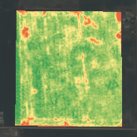
It is the future potential of remote sensing that adds fuel to his decision to work with the technology. "It is the wave of the future, but it takes time to adopt and adapt the practices. If you don't, you'll be like a company in the 1990s refusing to use computers."
Prior to signing up with FarmLogs, Bertsch was looking for better ways to track what was happening in his fields. While searching the Internet in 2013, he stumbled across the company and its services. He quickly progressed from a free introductory offering to full services due to ease of use.
"One of the things that attracts farmers is that we provide close to a turnkey system, and they don't have to do a lot to get prescriptions," says Dr. Tracy Blackmer, senior agronomist, FarmLogs. "The information overload is so large and so complex, a lot of people hesitate accessing it. What we offer is usable data."
FarmLogs and its approach aren't unique. Darren Howie, general manager of Trimble Ag Business Solutions, agrees that ease of use is vital to adoption of precision management practices at the farm level. Trimble’s software and services group is positioned to integrate business and data solutions to enhance decision-making.
Judge data services on value created
"Collecting and assimilating data from application, weather, soils and sensors can be overwhelming," says Howie. "We need to assure the information flow to farmers at the time they need to make decisions. It has to be easy to use and be accessible from desktop computers or mobile devices."
While the ever-expanding availability of data can be daunting, it can also make life easier, suggests Wade Barnes, co-founder and CEO, Farmers Edge. "As farmers use remote sensing data, they want even more of it, and they want it quicker. The problem is every service provider wants a percentage of the value created. Farmers get 'percented' to death."
Barnes notes that not everyone is ready for variable rate seeding or fertility applications. He advises farmers to constantly ask the question, "Did I make a better decision having the data than not having it? Can I live without it?"
Farmers Edge's rapid expansion internationally from its Canadian roots and a 95 percent customer retention rate suggests one answer. "They are hooked, not just because it is neat, but because they are making money with it."
FarmLogs user Bertsch would agree. "I am using remote sensing in multiple ways and rely on it more and more," he says. "Data lets me make actionable decisions, whether another feeding of 28 percent in a timely manner or which fields are dry and should be a priority."
About the Author(s)
You May Also Like

