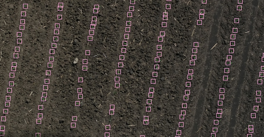
In a normal year, it takes four or five days after planting for a corn crop to emerge from the soil. But 2020 was not a normal year. Wet and cool conditions delayed emergence and slowed the development of crops in the early months of the growing season.
This complicated scouting for consultants and seed advisers covering large regions. To get across more acres faster, independent crop consultants like Erich Eller turned to aerial imagery analysis companies, such as Taranis and IntelinAir.
Related: Illinois startup IntelinAir plans to fly 5 million acres in 2020
Eller is president of ForeFront Ag Solutions in Huntington, Ind., and needed to scout more acres than usual this year. “Rather than hiring another guy, buying another drone and pickup truck, we just hire it out with Taranis now.”
Eller passes the company’s per-acre cost on to farmers. Both Taranis and IntelinAir offer flights, automatically analyzing imagery at around $5 per acre, depending on the package. Both companies boast well-trained artificial intelligence that can identify specific weeds, nutrient deficiencies and emergent crops.
Related: Doing stand counts from the air
Automated stand count and other services provided by the companies are an improvement compared to Normalized Difference Vegetation Index imagery from satellite companies.
“We were actually able to go to our growers and say, ‘Hey, you wanted 34,000 plants; there’s 15,000 out there,’” Eller says. “It’s not just some NDVI imagery you can’t make sense of. We were able to make real-time decisions on whether we should tear up a field or spot in.”
Related: Help best-producing soils grow more corn
With 0.3-millimeter camera resolution, the Taranis AI takes accurate stand counts of fields by the emergence, or VE, growth stage. It identifies insects, diseases, weeds and nutrient deficiencies — showing their likelihood over portions of fields where the AI notices something irregular.
The AI also investigates later-season flights to show which fields are drying down first, or to find which fields have been defoliated most by insects. Taranis provides daily satellite imagery, too, but it isn’t at a high enough resolution for the AI to analyze.
Trying out AI
For Eller’s first year with Taranis in 2020, some of the growers he works with volunteered to test out the service. Farmers paid an early-bird discount of $6.50 an acre for biweekly plane flights and three drone flights in the season. Other growers opted for satellite imagery from the company, with three drone flights, at $5 an acre.
Philo, Ill., farmer Steve Hettinger is also using the service for the first time this year on the farthest-flung fields on his operation.
“I’m impressed,” Hettinger says. He had a crop scouting crew count stands at around the V3 growth stage. Then Taranis flew over the next day with a fixed-wing drone. It came close to matching the stand count. However, he says there’s room for improvement with disease identification later in the season.
Hettinger says the Taranis AI misidentified a nutrient application problem as a disease on one of his fields. “They said, ‘You’ve got 33% disease.’ And I come to find out we put 32% nitrogen on sidedress, and it was sopping up on the leaves,” Hettinger says. Still, he’s glad the issue was noticed. “Plus, I can see a waterhemp as clean as a bell. I think they’re getting close.”
Hettinger, who also sells Dekalb and Asgrow seed, says he’s interested in buying camera equipment from Taranis so he can use the company’s AI software on drones he owns — potentially offering it as a service like Eller is doing for his customers.
Assist on-foot scouting
Eller says there will always be problems that need to be investigated on foot.
For example, when the Taranis AI program identified an area of a field that looked to have a potassium deficiency after a drone flight, he knew this couldn’t be the case. Soil tests showed the field had plenty.
It turns out, the portion of the field showing a potassium deficiency was compacted. Even though adequate nutrients were there, the roots weren’t reaching them. This led to yellowing on the lower leaves.
“We actually put in some liquid potassium fertilizer and foliar-fed that crop to get it through that stage,” Eller says. “With the drone and plane flights, it’s not just a pretty picture. It’s helping us make decisions in-season, and then come fall, we can go in and do so some tillage.”
Eller uses Fieldalytics software from EFC Systems to track the susceptibility of a farmer’s varieties and hybrids to disease and insect pressure. As Taranis reports incoming diseases from the flights he commissions, he’s able to triage what fields get sprayed first.
“The goal there is just to have an order of fields we can go to,” Eller says. While NDVI and other analysis on satellite imagery is helpful, he says it’s not as actionable as what the Taranis AI can tell him from high-resolution flight imagery.
“Instead of getting a picture with a bunch of colors and no one knows what it means, you can show 17 out of 20 points in my field are showing insect damage. That’s much more helpful. And we can act on it quickly,” Eller concludes.
About the Author(s)
You May Also Like


