Subscribe to receive top agriculture news
Be informed daily with these free e-newsletters

Many Iowa areas had timely rains last week, good news as corn is in the critical pollination phase.
Timely rains this past week were beneficial to crops in Iowa. However, there were isolated reports of damage to some crops and buildings caused by high winds and hail, according to the latest statewide weekly crop conditions survey by USDA’s National Ag Statistics Service. The survey, based on conditions for the week ending July 17, showed 67% of the 2016 Iowa corn crop had reached silking stage by that date. That’s five days ahead of last year at this time and a week ahead of average.
Corn silking nationally was at 56% as of July 17, up from the 46% average for the past five years. With Iowa at 67% silking, other key corn producing states were Illinois at 77% and Nebraska at 55%.

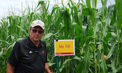
CORN POLLINATING: Iowa’s 2016 corn crop is pollinating and doing well. “About three-fourths of the corn here in north central Iowa is at silking stage or beyond,” says Bill Drury, who farms at Clarion. “Our corn and soybeans are looking good as we move into the last half of July.”
Across Iowa scattered reports of corn reaching dough stage
“In general Iowa’s crops remain in good condition with 81% of corn and 80% of soybeans rated in good or excellent condition. Many parts of the state have received timely rains, which is very good news with an extended period of high temperatures in the forecast for the rest of this week,” says Iowa Secretary of Agriculture Bill Northey.
Some early-planted Iowa cornfields are now beginning to reach dough stage as the 2016 crop continues to advance. Nationally, corn stayed at 75% good to excellent in the latest USDA weekly survey and soybeans stayed at 71% as widespread rains in the Midwest during the last week or so have helped crops.
The complete weekly Iowa Crop Progress & Weather Report is available on the Iowa Department of Agriculture & Land Stewardship website IowaAgriculture.gov or on USDA’s site nass.usda.gov/ia. The report summary follows here:
CROP REPORT: Timely rains last week were beneficial to crops. Statewide there were 4.5 days suitable for fieldwork for the week ending July 17, 2016, according to the USDA’s National Ag Statistics Service. But there were some reports of wind and hail damage to crops and buildings. Activities for the week included cutting hay and applying fungicide to corn.
Topsoil moisture levels in Iowa rated 3% very short, 12% short, 78% adequate and 7% surplus. Subsoil moisture levels rated 3% very short, 12% short, 80% adequate and 5% surplus.
Iowa corn crop 67% at silking stage, 5 days head of average
Iowa’s corn crop reached 67% at silking stage, five days ahead of last year at this time and a week ahead of average. Across the state there were scattered reports of corn reaching dough stage. Iowa’s corn condition improved slightly to 81% good to excellent.
Soybeans blooming in Iowa reached 66% and soybeans setting pods reached 20% last week. Both of these soybean stages were four days ahead of 2015 and five days ahead of normal. Soybean condition rated 80% good to excellent as of July 17.
Iowa oat acreage that is turning color or beyond reached 91%, with 35% of the oat crop harvested for grain or seed, four days ahead of last year. Oat crop condition is rated 79% good to excellent for Iowa. The second cutting of alfalfa hay reached 79% completed, 10 days ahead of normal.
The third cutting of alfalfa hay became more widespread at the end of last week. Hay condition was rated at 74% good to excellent, while pasture condition rated 61% good to excellent. Livestock saw some stress due to heat and humidity as well as overgrazed pastures in some parts of the state.
Temperatures averaged below normal, rain well above normal
IOWA PRELIMINARY WEATHER SUMMARY—for week ending July 17, 2016
By Harry Hillaker, State Climatologist, Iowa Department of Agriculture & Land Stewardship
The past reporting week began with very warm and humid conditions and widespread rainfall. Monday (July 11) was the warmest day of the reporting week with daytime high temperatures in the upper 80s to mid-90s. Thunderstorms were widespread from Monday (July 11) evening through Tuesday (July 12) morning with heaviest rainfall in the southwest where 1 to 2 inch amounts common. Thunderstorms were again widespread on Wednesday as a cold front moved across the state.
The greatest rainfall on Wednesday was from Des Moines eastward along the I-80 corridor with amounts around an inch. Mostly dry weather, with much lower temperatures and humidity, prevailed from Thursday through Saturday (July 16). Finally, much higher humidity moved back into Iowa Saturday night and Sunday (July 17) with the moisture surge bringing rain statewide early Sunday (July 17) morning with 2 to 3 inch rain totals common from the Iowa Great Lakes region eastward to the Mason City and Decorah areas.
Rain total was 1.65 inches, well above weekly normal 1.05
Rain totals for the week varied from only 0.10 inches at Rock Rapids to 4.38 inches near Storm Lake and 4.28 inches at Lake Mills. The statewide average precipitation was 1.65 inches or well above the weekly normal of 1.05 inches.
Temperature extremes ranged from a Monday (July 11) afternoon high of 94 degrees at Des Moines to a Saturday (July 16) morning low of 49 degrees at Elkader. Temperatures for the week as a whole averaged 1.1 degrees below normal.
Each rain event brought severe weather to Iowa last week
Finally, each of the rain events this week brought severe weather to the state as well. Monday (July 11) evening and night saw numerous reports of high winds, especially over west central Iowa. Wednesday (July 13) saw several reports of large hail in northwestern and west central Iowa and numerous high wind reports along and near I-80 in central and east central Iowa.
Finally, the most damaging weather of the week came with a derecho which entered the northwest corner of Iowa about 1 a.m. Sunday (July 17) and finally exited the state in the Quad Cities area about five and one-half hours later.
You May Also Like
Enter a zip code to see the weather conditions for a different location.


