December 3, 2019

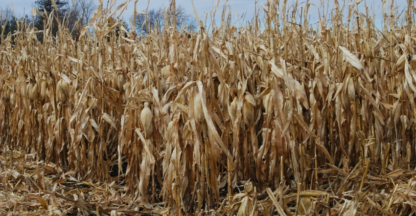
Rain and snow across Iowa last week kept farmers from finishing the state’s 2019 corn harvest. USDA’s latest weekly survey released Dec. 2 shows 8% of the corn crop is still in the field.
“Soybean harvest in Iowa is finished, with only a few bean fields left to be harvested. But we still have a significant amount of corn out there,” says Greg Thessen, regional director for USDA’s National Ag Statistics Service, based in Des Moines, Iowa. “The five-year average for corn harvest in Iowa is 99% completed by Dec. 1, and this year we are at 92%.”
Northwest and north-central Iowa are leading the way at 97% complete, while northeast Iowa at 83% complete and south-central at 84% are lagging furthest behind entering December. “With corn and some soybeans still standing in fields waiting to be harvested, this is the latest harvest since 2009, and farmers are anxious to finish up,” notes Iowa Secretary of Agriculture Mike Naig.
USDA says the U.S. corn harvest is now 89% complete, which is below the five-year average of 98% for the first of December. Several Upper Midwest states are still struggling. North Dakota is only finished with 36% of its corn harvested, while Michigan and Wisconsin are 66% complete. South Dakota is 80% finished with corn. USDA pegs the U.S. soybean harvest at 86% complete for 2019 vs. 97% a year ago.
The complete weekly Iowa Crop Progress and Conditions Report is available on USDA’s website at nass.usda.gov.
Crop report
Rain and snow suspended harvest activity and limited other fieldwork across much of Iowa as farmers were held to 3.1 days suitable for fieldwork during the week ending Dec. 1, according to USDA’s National Ag Statistics Service. Wet conditions have farmers inching toward the finish line as harvest 2019 nears completion.
Iowa corn harvest is now 92% finished, 11 days behind last year and two weeks behind the five-year average. Farmers in northeast and south-central Iowa have greater than 15% of their crop left to be harvested, while all other areas have 10% or less remaining. Moisture content of field corn being harvested for grain was 19% last week.
Livestock producers have been feeding hay and grazing cattle on cornstalks. Muddy conditions and snow-covered fields have been unsuitable for making bedding for overwintering livestock.
Weekly weather
Multiple strong low-pressure systems brought active weather to the Midwest, capping off the last week of November. All forms of precipitation — from rain and snow to freezing rain and hail — were reported across Iowa. Much of the state experienced unseasonable wetness with up to an inch above average across northern Iowa. Only southwest Iowa reported slight deficits.
Above-average snowfall was also reported across northwest Iowa with anywhere from 2 to 6 inches above normal. In terms of temperature, Iowa’s statewide average was 4.5 degrees warmer than normal at 34.2 degrees F.
That summary for the week ending Dec. 1 is provided by Justin Glisan, state climatologist with the Iowa Department of Agriculture. He also provides the daily details.
Warmer-than-average week
Warmer-than-average conditions prevailed across Iowa through Sunday (Nov. 24) under partly to mostly sunny skies. Daytime highs reached into the upper 40s across northern Iowa, while southern Iowa reported mid-to-upper 50s. The average statewide high was 53 degrees, 12 degrees above normal.
Slightly cooler temperatures persisted into Monday as a weak cold front pushed through, shifting winds out of the northwest into the evening. Light rain was reported at a handful of stations. Overnight lows remained well above average, with departures up to 16 degrees warmer than average; the average morning low of 30 degrees was 8 degrees above normal.
Cloud cover began increasing on Tuesday as winds shifted to the northeast. A mix of rain and snow fell across central and southern Iowa, and transitioned to moderate snow across northwest Iowa during the overnight hours. Near-blizzard conditions were reported as strong northern winds built in behind the system. Sustained winds peaked above 30 mph, with gusts in the 35 to 40 mph range. Estherville Municipal Airport (Emmet County) reported a peak wind gust of 47 mph with near whiteout conditions.
Snow totals reported on Wednesday morning were highest in northwest and north-central Iowa, with Sanborn (O’Brien County) observing 8.6 inches; over 40 stations reported totals above 3 inches. Thanksgiving Day (Nov. 28) was overcast with light rain and snow. Liquid equivalent totals were generally under 0.3 inch, while high temperatures remained in the upper 20s and low 30s. An additional wave of moderate rain moved through Iowa on Friday as temperatures remained above freezing. Heavier showers and isolated freezing rain were observed in Iowa’s northwest corner with O’Brien, Plymouth and Sioux counties reporting totals over an inch.
Precipitation cleared the state on Saturday morning, though overcast skies remained across much of Iowa in advance of a third low pressure system moving through Nebraska. Highs ranged from upper 40s north to low 50s south, where partly sunny skies allowed for warmer temperatures. Unstable conditions during the late afternoon allowed isolated strong thunderstorms to form across central Iowa.
A brief spin-up rope tornado was reported near Guthrie Center (Guthrie County), though no damage was observed. Pea-sized hail was also reported around the Des Moines (Polk County) metro area. As the last hours of November ticked away, the low pushed into Iowa, bringing light rain and snow showers across western Iowa as overnight lows hovered around the freezing mark. The average statewide low was 31 degrees, 12 degrees above normal. As of 7 a.m. Sunday (Dec. 1) snow totals were light and generally under a half of an inch.
Temps from 61 to 18 degrees
Weekly precipitation totals ranged from 0.15 inch in Red Oak (Montgomery County) to 2.27 inches in Sibley (Osceola County). Statewide average precipitation for last week was 0.83 inch, while the normal is 0.48 inch. The average snowfall across Iowa was 1.5 inches with Sibley (Osceola County) reporting 10.4 inches.
The week’s high temperature of 61 degrees was observed on Nov. 24 at Knoxville (Marion County) and Oskaloosa (Mahaska County), on average 18 degrees above normal. The week’s low temperature of 18 degrees was reported on Nov. 28 at Mason City Municipal Airport (Cerro Gordo County), which is normal. Soil temperatures as of Sunday were generally in the mid-to-upper 3
About the Author(s)
You May Also Like


