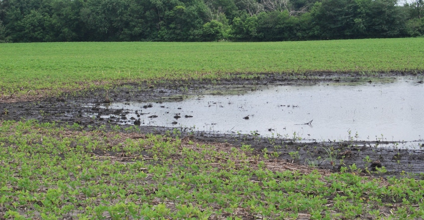
Heavy rain and strong winds damaged crops, trees and farm buildings in central and west-central Iowa this past weekend. These areas received 5 to 10 inches of rain Saturday night. Strong winds also caused corn to suffer “green snap” in some fields.
“Unfortunately, we saw a series of storms move across the state over the past week that have flooded fields and caused significant damage. Hopefully, the weather this week will allow the state to dry out so farmers can get into their fields to evaluate conditions and view any damage,” says Iowa Secretary of Agriculture Mike Naig.
Statewide, USDA’s weekly survey as of July 1 shows crop conditions didn’t improve compared to the previous week. Iowa’s corn crop is now rated 78% in good-to-excellent condition, down from 81% on June 24. Soybeans are 76% good-to-excellent compared to 79% a week ago.
Notify crop insurance agent of damage
If you experienced flooding over the weekend, check out the disaster recovery resources and information compiled by Iowa State University Extension. What should producers do if their planted crops are affected by flooding, wind or hail? Notify your crop insurance agent or insurance carrier within 72 hours of the loss. The agent’s company will assign a crop insurance adjuster who will work directly with the insured.
The complete weekly Iowa Crop Progress & Weather Report is available on the Iowa Department of Ag and Land Stewardship website at iowaagriculture.gov or on USDA’s site, nass.usda.gov/ia. The report summary follows.
Crop report
Strong storms brought damaging winds and heavy precipitation to much of Iowa, resulting in just 3.2 days suitable for fieldwork during the week ending July 1, according to USDA’s National Ag Statistics Service. Activities for the week included assessing crop damage and harvesting hay when the weather permitted. Wind and intermittent showers prohibited spraying activity to a large degree.
Topsoil moisture levels rated 1% very short, 5% short, 68% adequate and 26% surplus. Subsoil moisture levels rated 3% very short, 9% short, 66% adequate and 22% surplus. Heavy rainfall left many fields and pastures ponded. In south-central Iowa, the subsoil moisture supplies rated adequate to surplus increased to 46%, the highest percentage in these categories since the week ending July 9, 2017 — nearly a year ago.
As of July 1, the survey shows 7% of the corn crop has silked, a week ahead of both last year and the five-year average. It rated 78% of the corn crop in good-to-excellent condition. Also, 21% of the soybean crop has bloomed, four days ahead of last year and six days ahead of the average. Iowa’s soybean crop is rated 76% in good-to-excellent condition. The oat crop is 93% headed, two days ahead of average, while 25% of the oat crop is turning color, a day ahead of average. Iowa’s oat crop is 80% in good-to-excellent condition.
The second cutting of alfalfa hay reached 24% complete, a day behind last year and three days ahead of the average. Frequent storms continued to make putting up hay a challenge this week. Hay condition is rated 74% good-to-excellent. Pasture conditions rate 66% good-to-excellent. Heat and high humidity continued to stress livestock. Flooding limited access to pastures and muddy conditions continued to make feedlot operations difficult.
Weather summary
According to Justin Glisan, IDALS climatologist, last week began as a continuation of the previous week’s active weather pattern across much of Iowa. A low-pressure system over Nebraska streamed moisture and instability into the region, leading to widespread thunderstorms over the western two-thirds of the state June 25.
Flash flood warnings were still active in northwest Iowa from the weekend. In the early evening, Delphos in Ringgold County reported a rain-wrapped tornado lofting debris into the air. This thunderstorm moved northward into central Iowa. However, no damage occurred.
Many stations in central Iowa reported rainfall of up to 2.5 inches from a slow-moving line on June 26, as Iowa’s eastern third saw spotty thunderstorms. Waterloo reported 1.87 inches of rain. Temperatures were cooler than normal, with average highs departing by 3 to 6 degrees F east to west through June 27. Audubon in western Iowa recorded a high temperature that was 12 degrees below normal, at 71 degrees.
A cluster of severe storms rapidly moved through the state June 28 from Harrison County in western Iowa all the way to Lee County in the state’s southeast corner, leaving behind over 40 reports of severe straight-line winds and hail.
Torrential rain soaked central Iowa June 30
Heat returned to the state late in the week and through the weekend, with highs in the mid-90s June 29-30 across a large portion of Iowa. Heat indices reach the triple digits across Iowa’s southern half. The town of Logan in Harrison County had the week’s high temperature at 98 degrees on June 29. Thunderstorms, many with severe wind and hail reports, returned on June 30 as a cold front moved across the state.
In central Iowa, Ankeny, in Polk County, reported 10 inches, as torrential rainfall covered much of the Des Moines metro area. July 1 was the nicest day of the week. Temperatures moderated into the low-to-mid 80s in the northwest to low 90s in southeast Iowa, with ample sunshine.
About the Author(s)
You May Also Like


