October 10, 2017

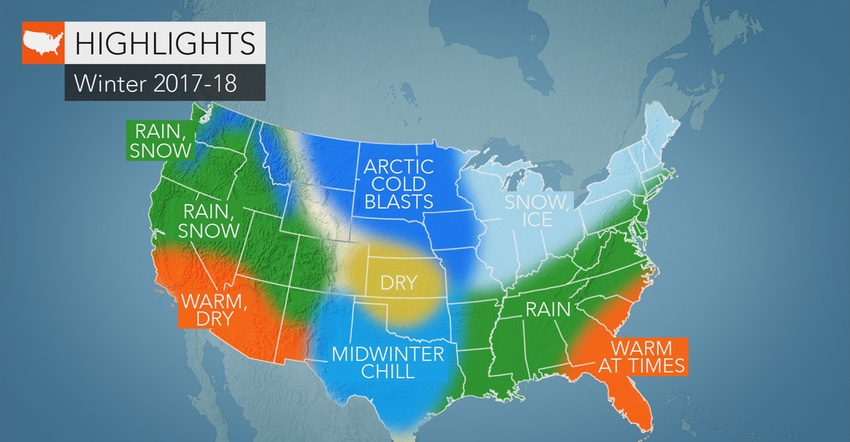
Too early for accurate winter weather forecasts? You might contend so. But AccuWeather meteorologists have almost bone-chilling accuracy. So here’s a quick peek at the first glimpse of winter for the major U.S. regions from Paul Pastelok, AccuWeather’s lead long-range forecaster.
Cold and snow for Northeast, Mid-Atlantic
A chilly winter is in store for the Northeast and Mid-Atlantic, particularly when compared to last year. For most of both regions, this will translate to an above-normal snow season.
“Areas in the I-95 corridor will average close to normal, within a few inches,” says Pastelok. Areas away from the Interstate 95 corridor have a better chance at a big early-winter snowfall.
Areas prone to lake-effect snow will also see high totals, including Cleveland; Erie, Pa.; and Buffalo, N.Y. Pastelok predicts this winter will bring a good ski season in the Northeast. Expect snow for the interior Northeast in time for the holidays.
Frigid, dry air to grip Northern Plains
Arctic blasts are set to freeze the Northern Plains this winter, with temperatures regularly sinking to subzero levels. Temperatures could plummet to −30 degrees F at times in the Dakotas, he notes.
So what’s new, you wonder? Those frigid conditions are a trade-off for less snowfall. After last winter’s colossal snowstorms, dropping 140% of normal snowfall over the Northern Plains and northern Rockies, this winter will feature much less snow and drier conditions overall. This would continue the region’s drought trend.
Upper Midwest to share a bit of both
Looking at the map above, you’ll see the dry, cold weather extending eastward into the Midwest, with moisture picking up (meaning snow and ice) in the eastern Corn Belt.
Severe weather for Southeast, Tennessee Valley
Farther south, air temperatures will face an east-west divide. “The Southeast is going to run above normal, especially in Florida and Georgia,” reports Pastelok. Both states will be at a lesser risk for a damaging freeze this year. Florida will remain mostly dry — good news for those recovering from Hurricane Irma.
Bouts of colder weather and a few ice storms are predicted to hit from the Tennessee Valley to northeast Texas, based on current weather patterns. Tornadoes aren’t out the question for either region. Frequent tornado activity may spin upward in February.
Yo-yo temps across Southern Plains
The Southern Plains will experience back-and-forth temperatures this season. Though the wintry air will be memorable, a cold winter isn’t predicted overall. Some areas, such as southwest Texas, will average above normal for the season.
“Colder air masses will bleed down and lead to freezes in later January,” says Pastelok. But overall, dry periods will dominate stormy weather. “There’re going to be some storms in northwest Texas at times,” he adds.
Southwest Texas could see some storms, but not as many as in past winters. Dry periods will be welcomed by many following the havoc wreaked by Hurricane Harvey near Houston.
Snowfall to bury Northwest, Rockies
With a weak La Niña predicted to develop this winter, the Northwest and the Rockies are set to receive abundant precipitation. “The Bitterroot chain all the way down to the Wasatch region in the central and northern Rockies has a good shot for above normal on snowfall,” says Pastelok. The Cascades are also predicted to benefit from abundant snowfall — if you’re a big skier.
Less snow for California, Southwest
After last year’s big snow season in central and northern California, both regions are predicted to be less wet and snowy in coming months. Drier, warmer weather will dominate the Southwest, with temperatures reaching into the 90s by early 2018.
Source: AccuWeather
You May Also Like


