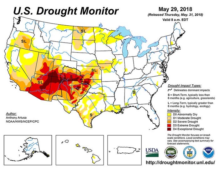
Droughts ebb and flow – that’s simply part of their nature. An occasional peek at the U.S. Drought Monitor, which is updated weekly, offers a glimpse into drought’s ever-shifting footprint.
That’s been especially true over the past nine or ten months. Starting last August, U.S. drought built slowly but steadily throughout this past fall and winter, only to degrade just as significantly throughout this spring.
Drought’s current footprint – covering 42.6% of the U.S. – sits at the lowest level since late November, when it covered a nearly identical 42.7% of the country. This drought hit a crescendo in late January, affecting 67.1% of the country, diminishing nearly constantly over the next 17 weeks.

Regional differences continue to abound. Currently, the most intense drought exists in the desert Southwest extending eastward into southern Colorado, southern Kansas, western Oklahoma and the Texas Panhandle. Much of this area will suffer long-term impacts, which the U.S. Drought Monitor defines as lasting longer than six months with hydrological and ecological effects.
Meantime, drought is largely nonexistent east of the Mississippi River, notes Climate Prediction Center meteorologist Anthony Artusa. That’s good news – except it brings little relief to current drought-stressed areas.
“[Through June 4], most predicted heavy rain areas are expected to be east of the Mississippi River, where little dryness and drought currently exist,” he notes. “West of the Mississippi River, smaller-scale heavy rain areas of a convective nature are forecast over North Dakota, Nebraska, and southwestern Missouri.”
From June 5 to June 9, CPC predicts normal or below-normal rainfall across most of the contiguous U.S., Artusa adds.
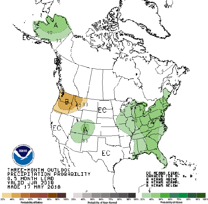
NOAA’s three-month outlook for June, July and August predicts wetter-than-normal weather to continue east of the Mississippi River, with abnormally dry conditions more probable in the Pacific Northwest this summer.

About the Author(s)
You May Also Like


