Subscribe to receive top agriculture news
Be informed daily with these free e-newsletters

Chateau Ste. Michelle uses NDVI imagery to more precisely harvest its grapes for improved wine, and profit.
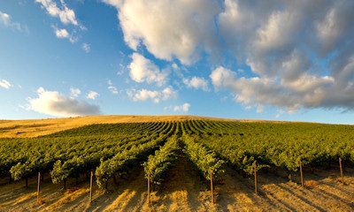
When many farmers think of precision agriculture it's those corn, soybean and wheat yield maps that come to mind, but other crops are maximizing use of high-tech information too. In Washington, the state's oldest operating vineyard – Chateau Ste. Michelle, Woodinville, Wash. – has long been in innovator, whether it's the use of mechanical harvesters or precision agriculture. And since 2003, the starting point has been an eye in the sky that can offer deeper insight into vine health and how best to harvest the crop.

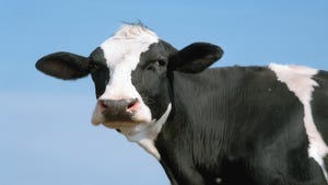
BEAUTY AND SCIENCE: A beautiful vineyard can earn a producer more money using technology to maximize the harvest. That's what Chateau Ste. Michelle is doing with NDVI maps and precision agriculture. (Photo: Chateau Ste. Michelle)
Back in 2003 the winery was working with Washington State University on multi-spectral imaging, a technology in its infancy then. "It's when we started using normalized differential vegetative index maps," says Russell Smithyman, director of viticulture, at the winery.
From that work the winery began using NDVI maps for a variety of analyses and three years ago the company started working with startup TerrAvion, a new player in the image-capture business (see related story). "We were looking for a provider that could be more flexible and less expensive," says Smithyman.
With TerrAvion, the winery can capture imagery every other week to gauge plant health and vigor. "At first we captured images weekly, but found every other week worked for us," Smithyman says.
Beyond yield
For Chateau Ste. Michelle, those NDVI maps are not only about looking at vine health for yield. Smithyman explains that the key indicator for the vineyard is the quality of the fruit. "For our reserve programs and wines we take fruit off the vine to get it at a lower crop level, where there are better flavors," he says. "Leaf area is integral in ripening and developing those flavors."
The maps can offer insight into how a specific field is advancing. He explains there is a vine balance – too much leaf area and the shading can change the flavor compounds in the grape, not enough leaf area and it impact grapes in other ways that can be negative. "NDVI shows the leaf area available and we work with that. We're looking for variability in the block [of vines] and we work with that to get the biggest bang for our buck in the block," he says.
Differential harvest is where the winery has excelled with the technology. During harvest, the winery can determine – with those maps – which grapes go to which future wines. "If we have a 20-acre block and see 30% with a smaller canopy, we would harvest that area separately and put that fruit into a different, higher-tier, program. That's a higher-priced bottle of wine," Smithyman explains.

MATCHING QUALITY TO PRODUCT: This map shows how NDVI information helps guide the harvest at Chateau Ste. Michelle. Harvesting those smaller areas differently, the winery can get more value out of those grapes in higher-value wines.
Essentially they're cherry-picking the vineyard to maximize income per acre. The winery buys two-thirds of its grapes from other growers and it will also fly those fields to determine if there's enough variability for a differential pick. "We image some contracted growers as well – for blocks we're less familiar with – it's beneficial to do those," he says.
The frequent imaging offers other insights as well, like in-season fertility issues, or water stress in the vineyard. They can identify if there's a problem with the drip irrigation system and take action to preserve leaf area and grape health. "We can see where tubes have busted," Smithyman says. "You might see a vine bigger right next to one that's has less leaf area, we'll go out and fix that irrigation tube." The technology is that precise.
Turning to the skies to get better insight into how vineyard blocks are performing is just one of the many innovations this leading winery takes on. It's the first to do differential mechanical harvesting too, and precision agriculture has been part of the mix since 2000. Adding timely aerial imagery to the mix just adds to the information available.
Innovating an innovation – TerrAvion rethinks aerial imagery
Flyover maps of fields aren't a new idea. Chateau Ste. Michelle Winery, Woodinville, Wash., was using a flight service in 2003 to capture the images, and that served them well. However, TerrAvion brings a few innovations to the industry that Chateau Ste. Michelle has found add value too.
TerrAvion started in 2013 and using cloud computing the company can deliver real-time aerial imagery services as frequently as weekly. The cloud-based system means that soon after the images are taken they're available for the client to review. "For us it's great because our viticulturists have access to the images when they need them," Russell Smithyman, director of viticulture says.
Robert Morris, CEO, TerrAvion explains that he led a drone platoon in the Army "and from that I took away that imagery is powerful for managing operations, and drones are a pain...and really expensive." When he left the military, Morris connected with a farmer friend who faced challenges irrigating and needed information from his farm for weekly decision-making.
Morris saw an opportunity and looked into using drones to capture the information. "I was going to build a drone to do this, we had a problem in need of a solution, we wanted to see all the plants," he recalls. "We couldn't make the numbers work with a drone."
But with airplanes, Morris saw the potential for capturing a lot of information efficiently. He acknowledges that satellite imagery can be efficient too, and priced right, but with clouds they can be unreliable; and you can't get the precise images that an airplane can capture. His answer? A fleet of airplanes using a special camera to capture multispectral imagery and provide it to clients frequently by having those processed images available in the cloud efficiently.
Taking out cost
"With legacy aerial imagery, post-processing is the biggest expense," he says. But he was working with Carnegie Mellon's robotics institute and its computer vision group – where he was getting a grad degree. Using automated post processing, Morris says his firm can process all imagery overnight at a negligible cost (compared to legacy systems) and make those processed images available efficiently.
Once Morris had pulled it all together the next step was price, which he explains is ½% of input costs. "The reason for that is we think when people take the information seriously they get about a 10% gross revenue increase to the bottom line with yield increases and input savings," he explains. "For them that's a 10-fold return on investment in the first year."
He explains that pricing the service was based on creating a price that was reasonable to growers, but also makes it worth it to tackle the new technology. "And we've gotten our price per imaged acre down," he says. That means the service would also work with more commodity crops like corn, soybeans and wheat.
Recently TerrAvion announced it had entered into a partnership with CHS, the largest U.S. farm cooperative, providing access to imagery service there too.
For more information about imagery, and the TerrAvion service, visit terravion.com.
You May Also Like
Enter a zip code to see the weather conditions for a different location.