It took a combination of factors in a short window of time. Rainfall in early March ranged from 2.5 to 4 inches in the Grand Island, Neb., area, where there was still about 25 inches of frost in the ground.
However, Hall County and the surrounding areas didn't have the same record snowfall that other parts of Nebraska did leading up to this year's intense floods. That, combined with flood control structures more than 20 years in the making, helped spare the farmland — as well as commercial and residential property in the area — from much of the flooding in early spring.
Two flood control projects, including the Wood River Flood Risk Reduction Project, completed in 2004, and the Upper Prairie, Silver, Moores Creek Flood Risk Reduction Project — also called the PSM project — which will be completed later this year, help protect a total of 25,000 acres of farmland and more than 6,900 commercial and residential properties.
The Wood River project was funded by the city of Grand Island, Hall County, Merrick County and the Central Platte Natural Resources District with help from the U.S. Army Corps of Engineers. The PSM project was funded by the Central Platte NRD, the city of Grand Island, Hall and Merrick counties, and the Nebraska Department of Natural Resources.
Grand Island didn't go completely unscathed this spring. Some areas north of Silver Creek in the northwest part of town saw flooding, but the area fared better than many places close to the Platte River.
"Based on planning that took place over the last 20 years, Grand Island fared pretty well," says Lyndon Vogt, general manager of the Central Platte NRD. "The Wood River project was finished in 2004, and in 2005, we had high flows and a lot of flooding. This year, flows were similar, and we were happy to see it perform as expected."
Diverting floodwater
These projects didn't happen overnight, however. The Wood River project first was set in motion in the 1980s by Central Platte NRD's former general manager Ron Bishop and former assistant manager Milt Moravek.
The PSM project got its start later, in the mid-1990s. These projects involve economic feasibility studies, working with local landowners, securing funding, garnering support from partners and obtaining necessary permits. Each of these can take several years.
After it was finished in 2004, the Wood River project got its first big test in 2005. According to numbers from the Army Corps of Engineers, the flood control project saved more than $23 million in damages in 2005 — compared with the project's cost of $15.5 million.
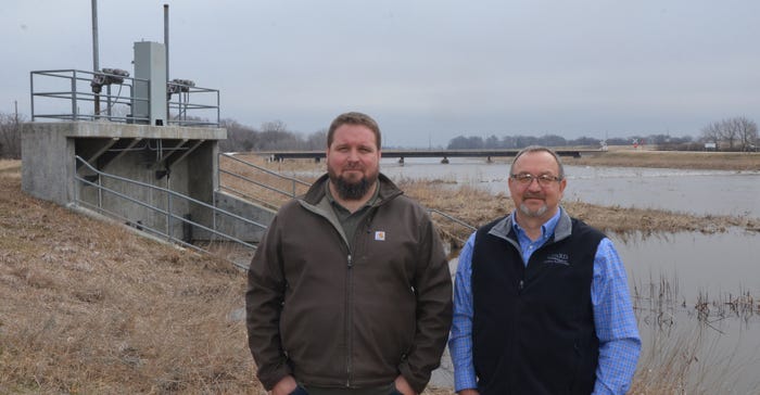
This project works by diverting water from the Wood River at peak flow periods — rerouting it away from farmland and the city of Grand Island and into the Platte River to the southeast. Contrary to popular belief, it doesn't work by opening the gates at the diversion point, but by closing them.
"That's a common misconception on this particular levee," Central Platte NRD assistant manager Jesse Mintken says. “These gates keep major floodwater from going down the Wood River through town and into farm ground in the Hall County and Merrick County area. We have the ability to completely shut it off, but we haven't had to do that yet. The floodway is around 7 miles long and diverts water to the Platte River, where there's typically more room to handle that kind of pressure."
The floodway usually starts diverting water once the water level at the gate is 4 feet deep. And while the floodway is used at least a couple of times each year, Vogt notes that most of the time, the floodway has no flow. The NRD closely monitors water levels at different bridges in Grand Island and in the eastern part of Hall County to determine when and how much to close the gate.
Holding back a flood
The PSM flood reduction project, which will be completed this year, includes three dams on Prairie Creek and one on Dry Creek — which drains into Prairie Creek — and a 590-acre detention cell northwest of town to prevent flooding on Silver Creek. The finishing touch will be a levee near Highway 2 and Engelman Road, a fail-safe if the dams and detention cells do not prevent flooding.
"The land is level enough, and Dry, Prairie and Silver Creek are close enough that they'll actually jump basin, and when we've got wide-scale flooding, we see waters mixing," Mintken says. "We experienced that this year with Prairie Creek coming out of its banks and coming into Silver Creek at Highway 2 and Engelman."
The detention cell at Silver Creek, which averages 6 feet in depth, uses an open box that reduces flows going into the creek down to about 80 cubic feet per second.
Prairie Creek and Silver Creek are overlapping watersheds. Prairie Creek often dumps into Silver Creek when it overflows. So, the goal is to hold water back from all three with a detention cell and emergency spillways to prevent flooding downstream.
At the peak of flooding, Vogt says the Silver Creek detention cell stored 5,000 acre-feet of water.
"I can't imagine how bad it would have been without the detention ponds," Vogt says. "That 5,000 acre-feet of water would have come through right in the peak of the flood event. They were as full as they could be. Water was running out of the emergency spillways for four days."
"Early on, the main issue is sand deposition and sheet and rill erosion in fields,” Vogt adds. “During the growing season when you have an event like this, depending on the stage of the crop and how long it's underwater, you could have some pretty good damage to crops. We see what happens to farm ground during a major flood event — just preventing that erosion and keeping top soil on your field is a tremendous benefit."
About the Author(s)
You May Also Like


