Subscribe to receive top agriculture news
Be informed daily with these free e-newsletters

Reviewing yield maps and determining what worked and didn't work are key winter tasks.
Even if harvest is wrapped up, the work isn’t done for 2016. Many farmers say now is a great time to plan ahead for next year. A big part of that planning is looking at yield maps to see what worked and what didn’t work in 2016.
This information comes from the Indiana Conservation Partnership. Members of the Natural Resources Conservation Service team contributing to this effort include Don Donovan and Clint Harrison. Both are NRCS district conservationists.
Yield map analysis
The talk at the coffee shop this time of year is typically about how well the crops yielded. What better way to prove you raised a record crop than a pretty yield map you can show off to everyone?

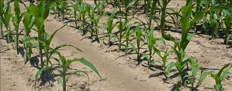
GROUND-TRUTH YIELD MAPS: Studying scouting pictures from during the season explains why these end rows showed up as low-yielding on the yield map. Soil compaction affected early-season growth.
Harrison thinks that yield map can give you so much more than bragging rights. A yield map can help you figure out problem areas in your field so you can plan for an even better crop next year.
For example, by comparing your yield map to a soils map, you may determine that some fluctuations in yield come from different types of soil on your farm. You may need to manage them differently. If you soil test, you may see where you need to amend your soil for next year. You may also see where you should start to increase your organic matter.
Other factors to evaluate along with your yield maps include these five things:
1. Crop hybrids. Be sure to account for different hybrids or varieties when looking at yield map results.
2. Topographical maps. These maps show low and high areas. If you have this information available, it can also show areas in the field that might be more susceptible to soil erosion.
3. Old land uses. To better understand yield maps, it helps to know the history of the field. Maybe there were old field boundaries or wood lots in what is now one large field. Knowing these things may help explain why you see yield differences. Read about a good example of this on Randy Overman's Peru farm.
4. Weather differences. If you have weather information available, consider it when you look at yield maps from various fields. If you farm over a large area, you may need weather data from more than one source to understand why your yield maps look like they do.
5. Compaction from high-traffic areas. In areas where yield maps indicate lower yield, one cause to look for is compaction. Typically, end rows tend to have more soil compaction because they see the most traffic in any one season.
Multiyear process
Harrison says it may take a few years for you to decide to make a large management decision based on your findings from yield maps. He encourages you to take a look at where the most loss occurred, and what would be the most economical things to change.
Comparing yield maps with these five factors in mind may help make that picture clearer. Improving precision application of fertilizer, chemicals and seed may help. Reducing soil runoff that is taking away your soil and nutrients is another option. Compacted areas may benefit from cover crops.
You may decide that perhaps a certain hybrid or variety is not suited to the soils and weather patterns that your farm sees in a typical year.
You May Also Like
Enter a zip code to see the weather conditions for a different location.


