

Subscribe to receive top agriculture news
Be informed daily with these free e-newsletters

Jet Propulsion Laboratory researcher Bill Patzert talks El Nino, La Nina and climate change.
Jet Propulsion Laboratory researcher Bill Patzert has been studying El Nino for 50 years.
"I started as a graduate student and just stepped into it as a career," he said. "It has never ceased to fascinate me."
What he knows for sure is that the current El Nino that is creating weather pattern havoc around the globe is a monster that will likely grow even stronger than the previous record El Nino of 1997-98. He says it is responsible for the steady, pounding rain that was falling across southern California during the interview for this article on Jan. 6 and that he anticipates a steady wave of storms arriving about every four days through January and into February.

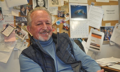
TALKING EL NINO: JPL researcher Bill Patzert has been studying El Nino and other episodes in nature that cause the movement and storage of heat in the atmosphere and the oceans.
In the 1983-84 and 1997-98 El Ninos, California had double the average annual snowpack and in February of 1998, Los Angeles got more than 14 inches of rain in 28 days, compared to a normal average of 3.5 inches.
Patzert doesn't exclusively study El Nino. He studies all the means and methods by which nature redistributes heat across the planet. He says an El Nino as strong as the current one is a massive redistribution, affecting the ocean and the atmosphere.
From that perspective, he has seen the reality of global warming, and he has no doubt that it is driving greater and greater volatility of weather events around the world.
"What we see now are normally occurring events such as El Nino taking place from a warmer background. So far, we expect that to mean more volatility in the weather. Whether it means we will see El Nino intensifying and occurring more frequently is still a subject of research."
As for the current El Nino, he said it has been building for a long time and for months before it affected North America it was "playing havoc" around the globe, bringing devastating drought to Southeast Asia and South Africa and flooding to South America.
As winter approached, the intensifying El Nino changed the flow of the sub-tropical jet stream sending storms from the west coast across the southern tier of the U.S. while giving the northern part of the country an unusually mild fall and early winter.
"As winter progressed, the movement of colder air down from Canada began colliding with that sub-tropical jet and that is when we saw December tornadoes in the southern U.S., something I call the El Nino 'Dixie Alley' effect," he said. "And it is what has brought the massive winter flooding to the Midwest."
For parched California it has meant welcome snowpack in the Sierra Nevadas and welcome but excessive rain for much of the state.
"The problem with the heavy rains is that it all runs off into the ocean and you don't get the benefit," he said. "For California, the answer to drought is really in the snowpack. That's what refills the reservoirs."
Patzert said forecasting of the current El Nino has the benefit of 23 years of continuous data recorded by satellites launched during previous El Ninos.
"The first satellite, Poseidon, was launched in 1992 in cooperation with the French government," he said. Then came Jason 1 and Jason 2 during the 1997-98 event. We will be launching another satellite adding monitoring capability of this event."
Satellite data has enabled JPL to keep track of the waxing and waning and track the strength of the El Nino of 2015-16, he said. So far that data shows a massive event that began building and affecting the eastern hemisphere early in 2015 and strengthening and delivering a punch to the western hemisphere during the winter months.
Many forecasters had been watching what they called the "blob," a pocket of warm ocean water off the coast of northern California that had shared the blame for steering high pressure across the state and prolonging the drought.
As El Nino strengthened, Patzert said, the blob has been swallowed.
"It is still there but is very shallow and has little power against the El Nino effect," he said. "I say that the Godzilla of an El Nino ate the blob."
That tends to be good news for California's forest lands, he said.
"The drought has been really hard on the trees. The groundwater is so low that the forests are under strees. There are 100,000 dead trees and kind of a non-stop fire season. The El Nino pattern should help that situation a lot."
What causes events such as El Nino and La Nina?
Jet Propulsion Laboratory weather researcher Bill Patzert says the origins of the recurring phenomenon such as El Nino and La Nina can be explained by looking at the heat generation and storage of Planet Earth.
"The tilt of Earth means that the tropics more directly face the sun and constantly gain heat over the year," he said. "The polar regions lose heat because during the winter they get no direct sun. Nature uses the atmosphere and the oceans to redistribute the heat of the tropics to the poles. Without that redistribution, the tropics would get hotter and hotter and the poles would get colder and colder."
There is a balance of redistribution, about half coming from the circulation of the atmosphere and about half coming from the ocean, he said.
But year to year, decade to decade, slight imbalances occur in how heat accumulates.
"Mother Nature has an answer for that," Patzert said. "She creates 'episodes' to help the planet catch up on heat redistribution. El Nino and La Nina are examples of that. As scientists, what we have learned is that you can see those episodes coming and once you do, it can't be turned around. You can forecast the impacts months in advance, but you can't change what's going to happen."
The episodic El Nino and La Nina events have been labeled the "El Nino Southern Oscillation" or ENSO by scientists who study how the periodic changes occur.
Patzert said that in the normal pattern, trade winds blow from west to east from the Americas to Asia, moving the warmest water of the tropics toward the coast of Asia. Satellites can measure this "piling up" of water by measuring the height of the surface of the ocean and the temperature of the water.
During an El Nino event, the trade winds die down or even reverse, allowing the warm pool of water from the equator to move to the west, piling up against the coast of Central and South America.
The change in where the ocean is warmest causes a change in where the most water vapor rises into the atmosphere and where the powerful winds of the jet stream are positioned.
How dramatic the changes are depends on how much warmer than normal the water becomes. The strength of the episode is measured by gauging how much above normal ocean height the warm water rises.
The current El Nino, officially declared last spring, has a 90% of chance of lingering at least through May, Patzert said and is one of the strongest on record.
Climate change is real and human activity is causing it
Jet Propulsion Laboratory researcher Bill Patzert has absolutely no doubt that the earth is growing warmer and that human activity, especially the burning of fossil fuels and the destruction of forest lands, is contributing to it.
"You can document it by the melting of the great ice sheets and the rise of sea level," he said. "It is the ocean that controls the climate of the planet. The atmosphere and the land gain heat during the day and lose heat at night. The ocean absorbs and stores heat."
Greenhouse gases in the atmosphere cause less heat to escape the atmosphere and upsets the balance of heat exchange, he said. And as much as 95% of the added heat that is not radiated back from the atmosphere ends up stored in the ocean.
He argues that whether they acknowledge it or not, all farmers know that climate change is real.
"Farmers know that the rainfall patterns and the temperature patterns have changed. They know there are more frost-free days and more heating degree days. They can see that the snow pack arrives later and melts earlier. That affects water management in a big way."
He said the sea level has risen 8 inches in the last century and the average temperature of the earth is 1 degree Centigrade warmer than it was 100 years ago.,
"California's beaches, like beaches around the world, are getting smaller," Patzert said. "Keep in mind that 75% of the population of the world lives within 25 miles of the ocean. Eventually, we're talking about an enormous movement of people."
Combined with the displaced populations of coastlines, Patzert says the world will also have to deal with the displacement of people from prolonged droughts and the damage resulting from steadily intensifying storms.
"The bottom line is we have to find a way to wean ourselves off fossil fuels and slow down the heating," he said. "We can't stop it entirely but it's our decisions and our actions that will determine whether we get hit in the head with a shot put or a whiffle ball."
You May Also Like
Enter a zip code to see the weather conditions for a different location.


