May 13, 2015

Shifting weather patterns brought warm, mostly dry weather to the eastern Corn Belt, while showers boosted topsoil moisture in the upper Midwest. Weekly temperatures averaged 5 to 15°F above normal in a broad area covering much of the Midwest, mid-South, and Northeast. At week’s end, a significant, late-season storm was underway across the nation’s mid-section, halting fieldwork but providing beneficial moisture for winter grains and newly planted summer crops.
In contrast, previously delayed planting activities accelerated in the eastern Corn Belt, especially across Indiana and Ohio. The warm, dry conditions extended into the Southeast, except along the southern Atlantic Coast. Tropical Storm Ana formed east of the Carolinas on May 7 and moved inland near Myrtle Beach, SC, around daybreak on May 10. Although Ana was the earliest named storm to make a U.S. landfall in the satellite era, impacts were minimal other than rough surf, gusty winds, and locally heavy showers.
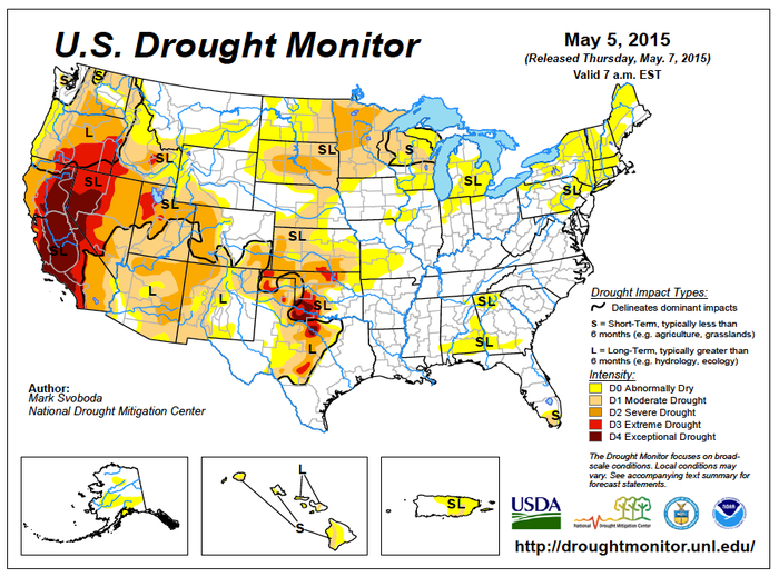
Farther west, heavy showers and locally severe thunderstorms hammered the Plains. Weekly rainfall totals in excess of 4 inches were common across Oklahoma and northern Texas, while most areas from central Texas to South Dakota received at least an inch. However, the Plains also endured several rounds of severe thunderstorms, including dozens of tornadoes.
Elsewhere, the West also experienced a pattern change, with cooler weather easing irrigation demands in California and the Desert Southwest. Significant, late-week snow accumulated across the parts of the northern Intermountain West and the central Rockies, but scattered showers provided mostly inconsequential relief in drought-stricken California and the Great Basin.
You May Also Like


