Subscribe to receive top agriculture news
Be informed daily with these free e-newsletters

Weekly USDA survey shows Iowa crops are catching up; but development is still running behind normal.
Warm, dry weather this past week helped Iowa's 2013 corn and soybean crops speed up development after a cool, wet spring delayed planting and got crops off to a late start. The warmest and driest extended period of weather this year was seen across Iowa during the week ending July 7, 2013.

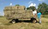
HELPING DAD BALE HAY: Darin Leach, a writer whose byline you see each month in Wallaces Farmer magazine, is shown with Kayla, his five-year old daughter. Darin and family spent several days recently at Darin's parent's farm in Muscatine County. "Lots of fun," says Darin. "We were outside by 7 a.m. so we could get as much of the harder work done before the heat of the day." That included unloading hay wagons. Darin reports some corn is beginning to tassel in southeast Iowa.
USDA's latest weekly Iowa Crops & Weather report is based on surveys statewide as of July 7 and the information was analyzed and released July 8. It shows corn is beginning to tassel in some scattered fields across the state. The amount of Iowa's 2013 corn crop in good to excellent condition increased to 58%, a one percentage point gain from the previous week. However, 12% of Iowa's corn crop is rated poor to very poor. Iowa's soybean crop is rated 44% good and 12% excellent in this latest survey; 11% is rated poor to very poor.
"The numbers to watch in the weekly report the next few weeks are the crop condition ratings," says Greg Thessen, director of the USDA National Ag Statistics Iowa field office in Des Moines, which conducts the weekly Iowa survey. Iowa's corn and soybean crops are lagging the national crops in development. As of July 7 only 6% of the U.S. corn crop was silking, versus 20% for the 5-year average. The Iowa crop hasn't started silking yet; it has barely started tasseling—not enough to even be rated numerically.
Much of this year's corn crop will be pollinating in what are usually the hottest times
Crop watchers will keep an eye on the U.S. corn crop in coming weeks, as about 43% of the crop was planted in a tight two-week window, and the lateness of that planting puts a lot of this year's corn pollination during what are likely the hottest times. How that may impact yield remains to be seen, notes Thessen.~~~PAGE_BREAK_HERE~~~
"The warm dry weather last week was very welcome and crops responded and look much better," observes Iowa Secretary of Agriculture Bill Northey. "Everything has been delayed by the cool wet start to the 2013 growing season, but the drier weather we've had recently has helped both the corn and soybean crops develop in Iowa and has allowed farmers to get back in the fields to finish any needed fieldwork."
The complete weekly Iowa Crops & Weather report is also available on the Iowa Department of Agriculture & Land Stewardship's website or on USDA's site. The report summary follows here:
Corn beginning to tassel in scattered fields across Iowa as of July 7
CROP REPORT: The warmest and driest extended period of weather this year was seen across Iowa during the week ending July 7, 2013. The weather allowed field crops to develop, although some areas of the state reported crops were beginning to need moisture. Statewide there was an average of 6.2 days suitable for fieldwork during the week, the most of any week this year. Northeast Iowa had only 5.8 days suitable for fieldwork and was the only district with less than six days suitable. Farmers were finishing side-dressing nitrogen on their corn fields.
The drier weather led to a decrease in both topsoil and subsoil moisture levels. Topsoil moisture levels rated 1% very short, 11% short, 76% adequate and 12% surplus as of July 7. Subsoil moisture levels rated zero percent very short, 4% short, 80% adequate and 16% surplus.
Survey shows 58% of Iowa corn crop is now in good to excellent condition
With reports of corn beginning to tassel in scattered fields across the state, the amount of the crop in good to excellent condition increased to 58%, a 1 percentage point increase from the previous week. Corn condition was rated 3% very poor, 9% poor, 30% fair, 44% good and 14% excellent.~~~PAGE_BREAK_HERE~~~
Looking at Iowa's soybean crop as of July 7, the survey shows 95% of the soybean crop has emerged; 3 percentage points behind the 5-year average. The condition of the soybean crop is rated 3% very poor, 8% poor, 33% fair, 44% good and 12% excellent. Ninety-four percent of the oat crop was headed as of July 7, which is 1 percentage point behind normal. And 23% of the oat crop has turned color, behind last year's 89% and the 5-year average of 51%. The oat condition rated zero percent very poor, 5% poor, 30% fair, 52% good and 13% excellent.
First cutting 2013 Iowa hay crop is 97% complete, about 30% behind normal
Farmers were close to wrapping up the first cutting of alfalfa and beginning to harvest the second cutting on July 7. The first cutting of Iowa's 2013 hay crop now stands at 97% complete, 1 percentage point ahead of normal, while the second cutting is 8% complete, 30 percentage points behind the 5-year average. Hay condition statewide is rated at 1% very poor, 4% poor, 26% fair, 53% good and 16% excellent. Pasture and range conditions are 1% very poor, 6% poor, 25% fair, 48% good and 20% excellent. Heat and insects were putting stress on livestock.
IOWA PRELIMINARY WEATHER SUMMARY—for week ending July 7, 2013
By Harry Hillaker, State Climatologist, Iowa Department of Agriculture & Land Stewardship
Iowa recorded its driest week in 13 weeks (early April) with most locations receiving no measurable rainfall. Most of the week's rain came on Tuesday (July 2) when showers and thunderstorms were scattered over the southwest two-thirds of the state. The greatest reported rainfall amount was 1.57 inches from a location a few miles north of Grinnell.~~~PAGE_BREAK_HERE~~~
Some of the stronger storms on Tuesday brought brief heavy rain and in some cases plentiful hail over small parts of central and south central Iowa. The statewide average precipitation was just 0.04 inches while normal for the week is 1.08 inches.
Last week, Iowa recorded its driest week in 13 weeks—with most locations receiving no measurable rainfall
The reporting week began with unseasonably mild conditions as temperatures averaged below normal from Sunday (June 30) through Thursday (July 4). Heat and humidity gradually returned over the weekend with scattered thunderstorms on Sunday (June 7) afternoon and night (which will be included in next week's report). Temperature extremes for the week varied from Monday (July 1) morning lows of 48 degrees at Atlantic and Chariton to afternoon highs of 93 degrees at Spencer on Saturday (June 6) and Des Moines and Newton on Sunday (June 7). Temperatures for the week as a whole averaged from two to three degrees below normal over the southeast part of Iowa to one to two degrees above normal over the northwest with a statewide average of 0.9 degrees below normal.
You May Also Like
Enter a zip code to see the weather conditions for a different location.


