August 1, 2018

Innovation has become a kind of watchword for agriculture with billions being invested into a range of ag technology tools. A lot of the innovation is focused on cloud computing and data analysis.
Sentera, a Minnesota based, company that focuses on unmanned aerial vehicle technology, is part of that revolution. The company launched its AgVault program last year providing cloud-based image and data management for farmers. This year, the company takes a bigger leap with a tech tool that offers plenty of potential for the future.
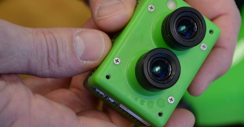
Sentera has put a computer in a drone sensor, which allows the sensor to provide real-time video and normalized difference vegetation index video on the fly. In addition, the system can capture field imagery and do immediate processing to provide the NDVI video instantly. With AgVault, those images can be nearly instantly available to farmers, and trusted advisers, for decision-making.
Farm Industry News got an advance look at the tool and talked with company officials about the technology. "We're very excited about this," says Greg Emerick, executive vice president, business development, Sentera. "No company has ever done this type of processing with the sensor. We've put the computer in our sensor to do the work."
The company's sensors have been used to image more than 25 million acres across the country. It's developers have worked on ways to manage imagery in the air, and on the ground, with the AgVault system. "We're the only company in the market that's providing a real NDVI video," Emerick asserts.
The company's drone image capture sensor actually has two sensors, one for visual images from the RGB sensor and a second for true NDVI from the near infrared - or NIR - sensor. Emerick explains that other approaches are taking the RGB data from standard imaging cameras that come stock on a UAV and doing math to emulate NDVI imagery. "In that case the data is no more than 80% accurate," he says. "With our sensor we're getting a true NDVI image."
In the past, producing that NDVI image meant pulling the sensor info from the drone into your computer. The breakthrough for Sentera is a sensor that has its own Snapdragon-chip onboard computer that does the math in the sky. "When we integrated the Snapdragon-chip into our Double 4K sensor last spring, we did it to enable our software innovation. Because of this we're now able to produce NDVI video in real-time," Emerick says. "This has never been done before."
And as you fly a field with this new Sentera sensor on board, you can actually see the visual and the infrared images during the flight. It's the filtering of the NIR data and the final math that provides the useful image, but that same real-time view can point to immediate hotspots to check too.
With real-time NDVI creation, which Sentera will call LiveNDVI, scouts using drones to collect and process information can get more done. The processing is done before the airship lands. That means you can cover more fields in a single day and not stop to process images.
This on-board processing power and NDVI map creation is really just the beginning. Emerick postulates some other potential uses for this flying computer. "What if you could do stand counts in flight? Or identify areas with nitrogen stress earlier than with tissue tests? Or identify weed areas, and even identify the type of weed in the area and generate quick maps of problem areas?" he asks.
The promise of this technology remains to be seen. But note the imagery from the sensor in the video below. You can see that the dual sensor is grabbing the visual (RGB) and the infrared (NIR) needed for creation of a true NDVI image. The onboard processor does the conversion work.
The new flying computer power from Sentera is being released this week. For more information about LiveNDVI, visit sentera.com. And watch the video below to learn more about this new technology.
About the Author(s)
You May Also Like


