Subscribe to receive top agriculture news
Be informed daily with these free e-newsletters

To provide more accurate rainfall amounts to farmers, researchers are using Dual Polarization Radar to estimate how much rain evaporates before hitting the ground.
How many times have you been driving around the farm and noticed a large shaft of falling rain off in the distance, but it looks as if it’s not reaching the ground? Dr. Neil Fox, associate professor, Atmospheric Science at the University of Missouri, has seen that weather scenario as well. He began wondering if there is a way to calculate how much rain finally makes it to the surface of the Earth in an area where a specific amount of rain was forecasted.
Fox started his career in London, England, where weather radar and forecasts are more focused on estimating potential rainfall amounts rather than on dangerous weather anomalies like tornados, straight-line winds, or hail. “We usually had slow-moving weather patterns that deliver the dreary rains for which England is so famous,” says Fox. “I used radar to help me do the best job I could at measuring how much rain might be expected over a wide area so we could warn the public about flooding or flash flooding possibilities.”
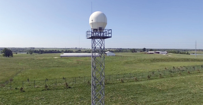
When Fox arrived in the U.S., he designed a research project where a relatively new type of radar system could be utilized — Dual Polarization Radar (DPR). Many older radar systems transmit radio waves with single horizontal polarization. DPR radar emits radio waves that switch the pulse transmitted between horizontal and vertical polarizations.
The two waves allow for a more in-depth measurement of precipitation rate and the ability to differentiate between types (rain, snow, freezing rain, or hail) of precipitation. “DPR allows us to obtain very specific data,” says Fox. “DPR has only been around since 2012, so researchers and scientists are still discovering uses for all of the new types of information it’s delivering.”
Columbia is over 100 miles from the nearest service radar located in St. Louis. Because of that distance and subsequent time lag in readings, often what the St. Louis-based radar picks up is not actually happening on the ground in Columbia — and other distant locations across the region. “A radar’s beam is angled slightly upward and by the time it reaches areas hundreds of miles away, those beams could be several thousand feet above the surface of the Earth.”
Through readings provided by the DPR, Fox, and his doctoral student Quinn Pallardy, who is writing the computer programming codes for the analyzation model, hope to develop a reliable method of calculating rainfall evaporation.
Farmers make frequent decisions related to soil moisture content, and irrigation based on the amount of rain that may become available for their crops. “We’re trying to increase the accuracy of weather information at their disposal,” says Fox. “This could even include knowing what amount of rain has fallen in every little square on a sectional map.”
The Earth’s atmosphere is in a constant state of flux. It is influenced by changes in humidity, darkness, light, moisture levels, and a myriad of other factors. “By comparing the two radar beams from the DPR, we can discern the average shape of raindrops,” says Fox. “The larger the raindrops, the less spherical they are in shape.”
Through their computer model, they can calculate how the raindrops shift or change as they travel through the atmosphere from the height the radar is transmitting their position. Based on existing atmospheric conditions, Fox and Pallardy can figure out which sizes of raindrops will evaporate before hitting the ground.
Larger raindrops will obviously evaporate more slowly and smaller ones more quickly. Their model takes into consideration those changing atmospheric conditions mentioned earlier, which also affect rain droplet evaporation. “With the DPR, we get a stronger signal from the horizontal beam if the raindrop is longer horizontally, and a stronger signal from the vertical beam if its vertical length is longer,” explains Fox.
By having this dual beam comparison, the researchers can calculate how many large raindrops there are compared to small raindrops. Fox and Pallardy are also using a weather prediction model that provides a forecast for the next few hours, rather than over the next few days, which weathermen typically rely on for their daily forecasts.
To be accurate, they know they must compare their evaporation forecast to actual rainfall measurements on the ground. To provide those ground readings reliably, they have a series of rain gauges at various locations around Columbia. “We also want to concentrate on our specific local area with this study to develop its accuracy and reliability before expanding the scope of the study on a larger geographic area,” says Fox. “We’re also trying to account for those incremental changes in the atmosphere.”
Fox hopes this method of evaluating rainfall evaporation will eventually be adopted by weather forecasting networks to estimate the amount of rain cumulatively hitting the ground. “Producers must make all sorts of decisions related to soil, soil moisture, irrigation timing, and the amount of rain made available their crops,” adds Fox.
DPR is helping to provide a vast amount of data, some yet unrealized. As their research progresses, Fox sees this type of rainfall measurement being used by weather prognosticators. “The more accurate the measurement of how much rain has actually fallen will augment and, hopefully, improve the accuracy of future weather forecasts,” concludes Fox.
You May Also Like
Enter a zip code to see the weather conditions for a different location.


