Subscribe to receive top agriculture news
Be informed daily with these free e-newsletters

Storms early in morning of July 11 brought damaging winds to areas of central and east central Iowa. Many cornfields are flattened, grain bins crumpled and buildings damaged.
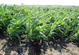
Straight line winds of 75 mph to over 100 mph ripped through central and east central Iowa in the early morning hours of July 11. Power poles, farm buildings and empty grain bins were no match for the winds as a path 30 to 40 miles wide and over 100 miles long was struck by the storm. There was no loss of life, but the yield loss to the maturing corn crop may be large.
The area of damage starts in northern Polk County in central Iowa and stretches along highway 30 from Ames to Cedar Rapids. There are other areas in east central Iowa and in eastern Iowa towards Dubuque where a number of corn fields are flattened or where the stalks are broken off. Soybean fields, which are lower to the ground, weren't bothered much. Corn is the crop that is of most concern.
USDA's weekly weather and crop report was released later on Monday afternoon July 11. However, that report , based on conditions statewide as of Sunday July 10, doesn't reflect the severe weather that caused so much damage in central and eastern Iowa early in the morning on July 11. "It's still too early to tell the full extent of the crop damage, but hopefully many of the corn plants in these fields will be able to recover," says Iowa Secretary of Agriculture Bill Northey.
The rain was welcome on July 11 but the strong winds were not
"The rainfall was welcome but the high winds weren't," says Iowa State University Extension agronomist Roger Elmore. ISU Extension agent Rich Wrage of Marshalltown says there apparently was no hail with the high winds that blew through central Iowa before dawn, but the winds did topple a lot of corn plants.
"Until six hours ago, this was a great looking crop we had in this area of Iowa," he said as he surveyed damage in Marshall County on Monday morning. "The corn was starting to tassel, and the pollination process was getting ready to begin soon." Sean Harmon, who farms near Ankeny in northern Polk County, said "It's sad because we had such a great crop going."
Elmore says all might not be lost for corn plants bent over by the winds. "If the corn hasn't tasseled yet, then it can grow and right itself, at least partially," he says. For that reason, the lateness of this year's corn crop and the tasseling and silking that are just beginning, these wind-hit fields may be fortunate.
While this year's corn crop is just beginning to tassel and silk, last year's crop was already 20% tasseled and silked by this time. "Tasseling and silking in 2011 are running behind 2010 because last year the crop was planted earlier when we had good early April weather," says Elmore. "This year much of the Iowa crop wasn't planted until May 10 or later."
Weekly report shows Iowa corn tasseling and silking have begun
Iowa's corn and soybeans are behind last year's pace in development and rainfall was below average last week, but Iowa's crops are still considered to be about 80% good-to-excellent. That's what the latest weekly weather and crop conditions report shows. It was released on July 11 by the Iowa Office of USDA's National Agricultural Statistics Service and reflects conditions as of July 10.
Iowa Crop Conditions as of July 10, 2011
This Week Last Week
Fair Good Excellent Excellent
Corn 14% 54% 28% 28%
Soybeans 16% 56% 24% 23%
Average temperature in Iowa for the week ending July 10 was 75.2 degrees F, which is 1.4 degrees above normal. Average rainfall was 0.3 inches, or 0.7 inches below normal.
The weekly report is available on the Iowa Department of Agriculture website at www.IowaAgriculture.gov or on USDA's site www.nass.usda.gov/ia. A summary of the report follows here:
Mostly dry, warm weather last week helped Iowa crops develop
Many areas of Iowa would have welcomed a nice soaking rain for the 2011 corn and soybean crops as the week ended July 10, while those people along the Missouri River continued to watch the elevated water levels and think about what might have been. A few flooded areas receded due to a levee breach down river, but most areas have seen the water level hold steady. Generally dry weather for the week ending July 10 allowed many farmers in the rest of the state to complete spraying of soybeans and first cutting of hay.
There were 5.9 days suitable for fieldwork statewide during the past week. Southeast Iowa led the way with 6.7 days suitable. Topsoil moisture levels rated 1% very short, 11% short, 79% adequate and 9% surplus. Subsoil moisture rated 1% very short, 6% short, 78% adequate and 15% surplus.
The 2011 Iowa corn crop has begun to tassel and silk, but most of Iowa has yet to see widespread tasseling and silking. Just 4% of Iowa's corn crop has begun to tassel and 1% has begun to silk. In an average year over one-quarter of the corn crop would be tasseling and 13% would be silking by now.
Corn is 54% good, 28% excellent; soybeans 56% good, 24% excellent
Corn condition is reported at 1% very poor, 3% poor, 14% fair, 54% good and 28% excellent. Also as of July 10, 35% of the state's soybean crop is blooming, behind the previous year and 5-year average of 43%. Soybean condition is reported at 1% very poor, 3% poor, 16% fair, 56% good and 24% excellent.
Looking at Iowa's oat crop, 45% percent of the oat crop has turned color, still lagging well behind the 73% in 2010 and the average 64%. Only 4% of the oat crop has been harvested with southeast Iowa leading the way. Oat condition stands at 1% very poor, 2% poor, 21% fair, 60% good and 16% excellent.
First cutting alfalfa hay harvest is 98% complete, just ahead of last year's 96% and the normal 97%. Second cutting alfalfa hay harvest, at 40% complete, is behind last year's 45% but ahead of the normal 38%. Condition of the hay crop is reported at 1% very poor, 6% poor, 28% fair, 51% good and 14% excellent.
Pasture and range condition is 1% very poor, 5% poor, 23% fair, 52% good and 19% excellent as of July 10. Fly infestations stressed some livestock, but most came through the previous week in good shape in spite of the heat and humidity.
IOWA PRELIMINARY WEATHER SUMMARY for week ending July 10, 2011
By Harry Hillaker, state climatologist at the Iowa Department of Agriculture & Land Stewardship in Des Moines
The past week began with temperatures slightly below normal on Sunday (July 3rd) with light to moderate rain falling over the southern one-third of the state. Temperatures and humidity gradually increased for the remainder of the period with highs mostly in the 80's along with a few 90's.
There was no widespread significant rainfall during the week. Isolated showers fell over northwest Iowa on Monday (July 4th) and were scattered across the western one-half of the state on Tuesday (5th). Wednesday (6th) was dry while thunderstorms were scattered over the southeast one-half of Iowa on Thursday (7th). Dry weather prevailed on Friday (8th) with a few isolated thunderstorms over the far northwest on Saturday (9th). Finally, a few thunderstorms were scattered over the northern one-half of the state on Sunday (10th) morning.
Rain totals varied from none over much of east central Iowa to 2.26 inches at Bedford and Hamburg in the southwest. Statewide average precip was 0.30 inch while normal for the week is 0.99 inch. This was Iowa's driest week in 9 weeks.
Temperatures varied from Monday (July 4) morning low of 52 degrees at Elkader to afternoon highs of 95 degrees at Sioux City on Saturday (9th) and Sunday (10th) and also at Keosauqua on Sunday. Temperatures for the week as a whole averaged near normal over the southeast and two to four degrees above normal over the northwest with a statewide average of 1.4 degrees above normal.
You May Also Like
Enter a zip code to see the weather conditions for a different location.


