No one can predict the future accurately, not even with a crystal ball. It’s impossible to predict what technology might be available even by 2025. So when Purdue University Agriculture research leaders designed the section of the new Indiana Corn and Soybean Innovation Center that would house equipment that actually goes into the field to collect data, they attempted to cover all bases. They constructed an extremely tall, extremely long, relatively narrow work bay that suits the needs of both those using ground machines and pilots preparing small unmanned aerial vehicles for flights to gather data from the air.

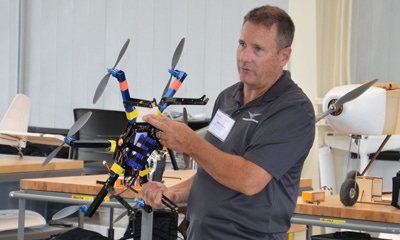
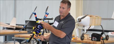
PART OF PURDUE’S ‘PLANT AIR FORCE’: Mike Leasure displays just a portion of the unmanned aerial vehicles that pilots use to collect data from the Purdue Agronomy Center for Research and Education fields.
Mike Leasure is in charge of the UAVs and the pilots who operate them. A teacher in Purdue's aviation program, Leasure devotes part of his time to overseeing care of the UAVs and flights that take place at the Purdue Agronomy Center for Research and Education.
Leasure has worked with crop consultants to figure out how to gather data from UAV flights for more than a decade. It’s only natural to find him helping get this pioneering program in data collection off the ground.
Fixed vs. rotor
The stable of UAVs in the work bay includes both fixed-wing and rotor-type aircraft. Which one you select for a flight depends largely on the type of data you’re trying to collect, Leasure says.
“Each has its own niche,” he explains. “If you need lots of data over a broad area in a short amount of time, then fixed-wing aircraft are a good choice. They can cover more ground per flight, allowing them to collect data over more acres.”
What they can’t do is stop and hover, he notes. “They can slow down, but they can’t stop,” Leasure observes. “If you are after intensive data within a few small plots, then a rotor-type UAV would be a better choice.”
Rotor-craft can literally hover in one spot while cameras collect images according to preprogrammed flight patterns. They typically can’t stay up as long, but the ability to both launch and land vertically and hover makes them good candidates for tasks where fixed-wing craft might have difficulty taking off or landing due to obstacles, or where lots of intensive data needs to be collected in a small area.
Future implications
“One thing we’re still learning about is how much data we can collect, and how much data researchers can analyze,” Leasure says. He notes that it appears they can collect far more data than researchers can analyze in a reasonable amount of time. Going forward, the challenge will be figuring out how to focus on the most meaningful data, he says.
By midsummer, a crew of five licensed pilots had conducted 36 data-collecting flights over the agronomy center, Leasure reports. That means tons of data will be available from 2016 alone.
Under new Federal Aviation Administration rules, people will be able to obtain a license to fly UAVs without needing a license to fly manned aircraft, Leasure says. That will increase the number of people who can fly UAVs for data collection in the future.
About the Author(s)
You May Also Like


