July 14, 2021

Cody Overton wants to ensure his crop stands emerge well, and if there’s trouble, he wants to act fast. In the past, that meant quality time in a side-by-side traversing fields, which was time-consuming and not always productive. Today, he gets the information he needs from a drone.
“Before drone technology and the software they have, you would walk, drive or scout a field to look where you might possibly need to replant,” says the Mattoon, Ill., farmer.
He notes that he might find one area where attention was needed but leave another poor stand untouched because it was missed. Now he has full visibility of his crop stand, and he can make decisions quickly.
In fact, it’s possible to make replant decisions while still involved in the initial planting phase. “You’re typically thinking replant when I was still getting my first planting done,” he says. “We had a lot of rain, and I can’t stop the planter and go look at fields to check for replant when I still have first planting to do.”
Adam Kaufman, Overton’s Pioneer seed representative, is working with software developed by DroneDeploy and used by many Pioneer seed dealers. Corteva Agriscience developed the Stand Assessment analytics tool within its digital research and development program, and then licensed the technology to DroneDeploy. Through the partnership of DroneDeploy and Corteva, the Stand Assessment tool is now available to all agriculture customers.
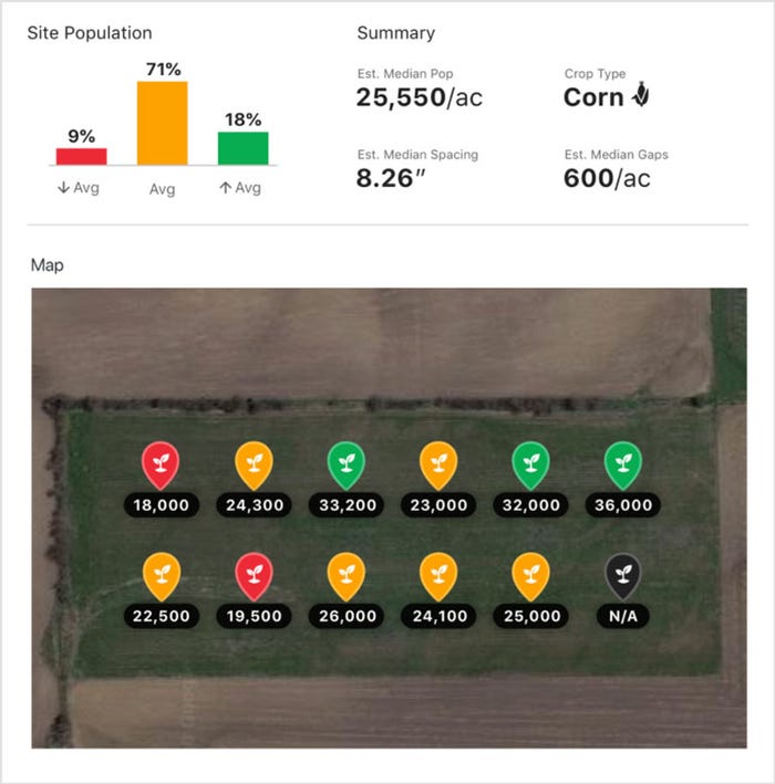
 FINAL REPORT: This at-a-glance view of a single field’s stand count can quickly identify areas of trouble. The Stand Assessment tool is available through DroneDeply.

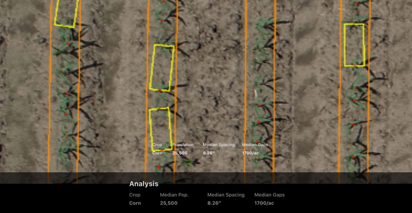
The Stand Assessment tool allows offline, real-time stand counts at the field’s edge, providing a farmer the full assessment quickly. “It really gives the farmer perspective on their need to reseed,” says Jeff Schmidt, chief revenue officer for DroneDeploy.
Using a drone to do stand assessment does more than save time, Schmidt explains. Having that information quickly provides some peace of mind to the farmer. “We’re essentially removing the manual side to this, and you can cover a field in an automated way,” he says.
In the field
For Overton in Illinois, having that information quickly is a help, but it’s also a benefit for Kaufman, too, according to Paul Yoder, Pioneer field agronomist. “Everything Cody and Adam share complements things from a time standpoint,” he says. “If there is a problem field and Cody has to replant, Adam may not have the seed in the shed, but he can speed up the efficiency of delivery because he knows what he needs more quickly.”
Yoder notes that when Overton is ready for the replant, Kaufman can have the seed ready to go with no wasted time, at a key part of the season. “That boosts the possibility of a higher return on investment with timely replant,” he adds.
For Kaufman, adding the DroneDeploy system as a service was a big investment, but he’s seeing a payoff. “As with anything new, there can be glitches. I’ve worked with it for a couple years, and it’s good to see the progress being made,” he says. “In the future, I hope we get to a point when we can fly the field sooner when the crop is even smaller and make decisions even earlier.”
But there’s software beyond the Stand Assessment tool. Kaufman can fly farmer fields deeper into the season and provide crop health imagery. And Yoder points to another feature from DroneDeploy — it’s the ability to build a panorama of a field, essentially stitching together high-resolution images to create a complete field image.
“It’s like you are Iron Man hovering over the field from 200 feet. It stitches together images in a 360-degree view,” Yoder says. “If you see something in the image, you can zoom in on that area and get a very clear picture.”
Potent image
The Live Map Gen 3 Beta has been made more powerful and can provide real-time mapping of a field, allowing users to image more than 200 acres in a single 15-minute flight on a single battery.
Yoder shares that his representatives are finding new uses for the imagery, too. Just this spring, Overton had a field issue with drainage.
“We had a field tile but didn’t know where the tile was,” Yoder recalls. “I talked to Adam and had him fly the field with panorama view to see where the tile was.”
The image became an “almost perfect” representation of where the tile was on that 80-acre field.
“We were able to map that 80-acre field, and we could see down to the row and count the rows to determine there were tile lines every 80 feet,” Overton says. “There were not old maps of record and we were able to map it.”
Drone imagery has value as more tools like Stand Assessment and Live Map become available. You can learn more at dronedeploy.com.
About the Author(s)
You May Also Like


