Subscribe to receive top agriculture news
Be informed daily with these free e-newsletters

Think DifferentDale Crawford, a Sullivan, Ill. corn and soybean grower, fell for unmanned aerial vehicle (UAV) technology the first time he recognized tile lines in a field where he did not know they existed. Other ways UAVs could fit into tomorrow’s precision-ag diagnostic tools:Fly the same path daily, weekly or as desired, at canopy level, at bargain-basement costs.Gather images with normal light, infrared or thermal, with each image georeferenced for easy ground-truthing.Evaluate germination, stem count, plant emergence and disease or insects early.In the near future: Identify individual plants, georeferenced, for followup attention and get alerts of potential crop epidemics such as those producing mycotoxins, based on researcher recognition of aerial spore movement.FAA approval to fly them commercially is expected by Sept. 30, 2015.
November 29, 2012
Dale Crawford has his own crop-scouting drone...sitting in the basement. The Sullivan, Ill., corn and soybean grower bought the Canadian-built, CropCam fixed-wing-style, unmanned aerial vehicle (UAV) after seeing one at Commodity Classic about five years ago. He was intrigued by the idea of doing aerial photos for his fields and possibly others.
"I experimented with it some that summer, flying and taking pictures, but I had a couple of rough landings requiring some repair," Crawford says.
"Flying one isn't as easy as it was portrayed. There is a lot involved if you want to use it as a hands-on tool."
Remote sensing with satellite images are proven tools, but they also are expensive and subject to the weather. By contrast, a UAV can be programmed to fly the same path daily, weekly or as desired, at canopy level if desired and at bargain-basement costs.
Images can be gathered with normal light, infrared or thermal, in still and video formats with each image georeferenced for easy ground truthing and replication. Available in a variety of fixed-wing and rotary-wing styles and sizes, UAVs offer superior resolution to other aerial images. This potential was demonstrated at an Iowa Soybean Association On-Farm Network research site this past summer.
A third-year corn field planted with a Pioneer Herculex rootworm-resistant hybrid had been treated with alternating (and replicated) strips of half and full rates of Aztec insecticide applied with a SmartBox at planting. Even with the combined insect protection, normal aerial imagery had shown considerable lodging.
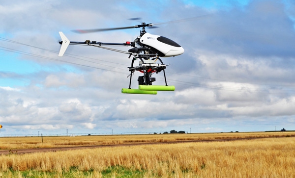
Rory Paul, Volt Aerial Robotics, a St. Louis, Mo.-based UAV consultant and industry advocate, flew his quad-rotor system over the field. "Lodging was even more visible with photos from the drone," says Tracy Blackmer, director, On-Farm Network. "We used both our normal imagery and the drone imagery to locate field areas with the most lodging, so we could go back in later and pull plants for root ratings.
"In one 20-minute flight over 200 acres, we provided coverage of 3.5 in./pixel, enough to identify individual plants," Paul says. "If optics are good enough, eventually we may be able to detect pests optically."
David Schmale, associate professor, plant pathology, physiology and weed science, Virginia Tech University, is taking pest detection to a level beyond optics. His research team is scouring the air above the University's research farm for Fusarium spores and finding them. The cause of a number of devastating diseases, Fusarium has at least 80 biological species, with even more differentiated on a DNA level. Using isolates of Fusarium gathered on site and in other regions, Schmale has demonstrated that some of the spores overhead are not native to the local soil.
"One of the strains of Fusarium graminearum we collected produces a rare mycotoxin that we've been unable to uncover from isolates collected on the ground in Virginia, suggesting it comes from out of state," says Schmale.
Until now, most microbial research has focused on those in the soil, the plant/soil interface and the plant canopy. His research adds atmospheric microbes to the mix. Schmale is confident this work will contribute to an early warning system for potential epidemics.
"Ideally in the next decade, we would have UAVs scouting for agents that are a threat to plant, animal or even human health," he says.
Unfortunately, research funding restrictions, as well as FAA restrictions on when UAVs can be flown, where and how high, are directly impacting advances in this area. While remote-controlled model aircraft have been flown for many decades, UAVs flown under autopilot and not within sight of the controller are highly restricted, pending new rules. In the meantime, only limited use for research is allowed, though farmers such as Crawford can use them on their own property.
"Currently commercial operations defined as for hire are prohibited," says an FAA spokesperson. "Personal use such as on a farm is normally considered recreational even though it is being used for the owner's business. Users have to follow model aircraft guidelines of flying under 400 ft., at least 5 miles from an airport and away from populated areas."
Recent legislation directs the FAA to safely integrate unmanned aircraft into the nation's airspace not later than Sept. 30, 2015." The FAA spokesperson says proposed language for small, unmanned aircraft likely to address a variety of users including commercial operations, is in the works.
"If we find out about a commercial operator, we ask that they stop," says an FAA spokesperson. "Theoretically, if they didn't stop, they could be subject to civil penalty."
Paul chafes under current restrictions. For the past five years he’s consulted with potential users, conducting training and carrying out limited research flights, but has been unable to offer commercial services to growers.
He's not the only one waiting. Maynard Herting, executive director, UAI International, is part of a consortium of non-profits, government agencies, academics and private industry in North Dakota preparing for commercial use of UAVs. He sees agriculture benefitting substantially.
"With UAVs, farmers will be able to evaluate germination, see what stem count is, index plant emergence and catch disease or insects in one spot early, mitigating cost down to almost a hand application," suggests Herting. "With hyperspectral activity, including long-wave infrared and short wave, we can filter out certain colors and identify certain characteristics in the plant or the soil."
Manned aircraft have been used with LIDAR, (Light Detection and Ranging) to gather a complete topographical data set for the Red River Valley. Herting reports that data is being used for tiling and other field drainage. When the FAA rules change for UAVs, this type of data can be inexpensively gathered by UAV aircraft.
While Paul can't begin selling systems or offering remote-sensing services in the U.S., he is considering relocating to South America or South Africa where UAV use is skyrocketing. "I'll be able to iron the kinks out of the system," he says.
When the FAA opens the doors, he plans to be back and in business. American farmers are eager for UAV benefits, says Paul. "People are starting to realize this is a missing component of precision ag," he says. "It's not new. It's been done with full-size aerial vehicles, but it's been cost-prohibitive. The impact will come when we see broad adoption by farmers and agronomists who understand the benefits. Eventually it will happen because it is the logical thing to do."
You May Also Like
Enter a zip code to see the weather conditions for a different location.