Subscribe to receive top agriculture news
Be informed daily with these free e-newsletters

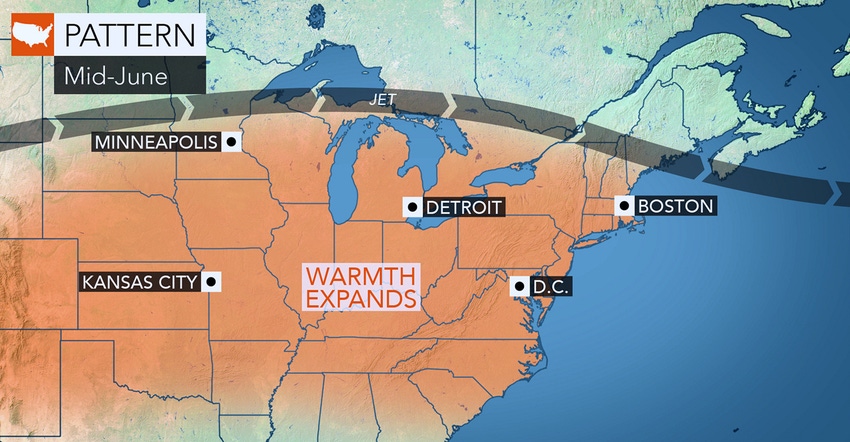
Warmer dry weather to arrive soon for Northeast corn and soybeans.
Farmers up and down the Northeast are making progress planting or replanting crops between showers. As of June 10, corn planting hovered between 88% to 93% complete in most of the region, according to USDA's National Ag Statistics Service. That's not counting replanted acres. A lot of the crop went into the ground during the last two weeks — long after optimum planting date.
Soybean planting has also been delayed. That may reduce conventionally planted bean yields closer to double-crop yields in some areas.
But spring's pattern of soggy soils may finally break into normal warm weather around mid-June. That's what AccuWeather meteorologists predict. June is expected to end above normal in temperature. Whether it's warm — and dry — is still to be called.
"The overall pattern up until around June 13 to15 favors a northwesterly flow aloft which should send multiple weak storms through the region with chilly air in their wake," says AccuWeather lead long range meteorologist Paul Pastelok. When it does rain, it'll be more of a nuisance with sporadic showers and locally heavy thunderstorms. In other words, more of the same.
Then cometh dry air?
Toward the middle of the month, the jet stream is likely to retreat northward, and the pattern will come to an end. "For at least a few days during the third week of June, we expect warm and more humid conditions to build from the Midwest to the Northeast," Pastelok says. Temperatures are likely to average 10 degrees F above normal during the middle of the month.
Hot weather enthusiasts may have to hold out until mid-month for a multiple-day stretch where highs will be well into the 80s to near 90 degrees F. However, he warns, it's possible that cool weather may fight back over the Great Lakes and much of the Northeast late during the third or early in the fourth week June. So, mobilize your haying equipment to lay down wide (fast-drying) swaths, and knock out those fields as fast as possible.
You May Also Like
Enter a zip code to see the weather conditions for a different location.


