For over 30 years, the Conservation Technology Information Center has monitored conservation practices in the U.S. at the aggregate level through the National Crop Residue Management Survey, and more recently, through the Operational Tillage Information System (OpTIS) — a tool developed in partnership with The Nature Conservancy and data science company Dagan Inc.
OpTIS uses satellite-based remote sensing to monitor conservation practices like reduced and conversation tillage and cover crops at the field level, and can be used to follow patterns in conservation practices across space and time — including the percentage of acres and number of acres with cover crops and conservation tillage (classified as greater than 30% residue) broken down by crop reporting district or HUC8 (8-digit hydrologic unit code) watersheds across the Corn Belt or in individual states on the OpTIS website.
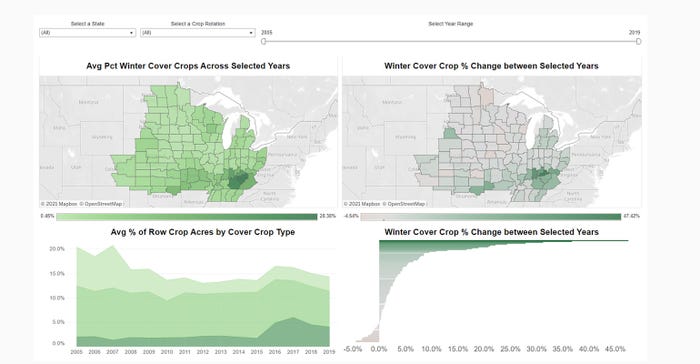
 TRENDS OVER TIME: In addition to adding new regions and the 2019 cropping season, the OpTIS visualization tool features some updates in how data are presented. The tool now includes the ability to choose from a two-year crop rotation, and a new bar chart showing trends and changes in practices over time by region.

The information is processed at the field level, but summarized and distributed at the aggregate level for public insight. Estimates for residue cover are based on observations from multiple satellites throughout the cropping season, and compared to observations on the ground, as well as county-level USDA National Agricultural Statistics Service Census of Agriculture data.
Updates in space and time
Recently, CTIC has partnered with The Nature Conservancy and Regrow — a new company created by the merger of Dagan and FluroSat — to implement several updates to OpTIS.
In a June webinar, Steve Hagen, chief research officer at Regrow, discussed the latest version, OpTIS 2.0. Until recently, OpTIS provided data from 2005 through the 2018 cropping season. With the new updates, OpTIS data now includes the 2019 cropping season as well as new states and regions.
"We're including information for a cover crop from the 2018-19 winter season as well as spring tillage in 2019 and fall tillage in 2018," Hagen says. "We've added new watersheds in Wisconsin, in Michigan, in Tennessee and Kentucky, and we've expanded to cover all of Kansas. Our expansion across Kansas is our first application in an area where wheat is dominant."
The expansion into western Kansas accompanies an adjustment to the OpTIS algorithm that extends the observation window to allow for improved residue cover estimates after winter wheat harvest.
Hagen notes that after the OpTIS initial release, questions arose regarding specific management scenarios — questions like: How often are cover crops planted into corn residue? How often is no-till done before planting soybeans? How many acres are under no-till with cover crops?
So, the new release provides summaries and acreage totals with different combinations of practices and across crop rotations — from one summer crop through the next season's summer crop.
"For example, one year after corn is harvested, we can look at how many acres after that corn harvest were no-tilled in the fall, where no cover crops were planted in the winter, where no-till was done in the spring, and then where soybeans were planted in the summer," Hagen explains. "We've really expanded the view into how practices are used in combination."
In addition, the OpTIS visualization tool now includes the ability to choose from a two-year crop rotation, and a new bar chart showing trends and changes in practices over time by region.
Trends in conservation
Hagen also outlined some patterns highlighted with the latest OpTIS updates. This includes clusters of heavier cover crop use in places with longer growing seasons and higher annual precipitation.
"Some patterns can be linked to climate and environment conditions, like the higher prevalence of cover crops in the southern part of the study area," he says. "Other patterns seem to align more with administrative boundaries — like the cover crop use pattern on the border of Wisconsin and Minnesota. That sticks out as an administrative boundary cluster that we see."
There have also been changes in conservation tillage and cover crop use across the OpTIS coverage area in the last 10 years.
"We see the use of conservation tillage retreat a little bit from the highs seen in the first half of the 2010s, from where we had about 50% conservation tillage use observed in the first half of the decade. That dropped a bit to 43% on average in the second half of the decade," Hagen says. "On cover crop use, we've seen cover crop use double from the first half of the 2010s to the second half."
Hagen notes more updates are coming — including additional geography and cropping seasons.
"We're adding a couple of key geographies, including the Chesapeake, the Mississippi Delta and the Great Plains. We're continuing to add new years, including 2020 and beyond," he says. "We're always looking to make algorithm improvements, including improvements based on information we've gathered from comparing to ground observations and the ag census."
Learn more at ctic.org/optis.
About the Author(s)
You May Also Like


