September 10, 2019
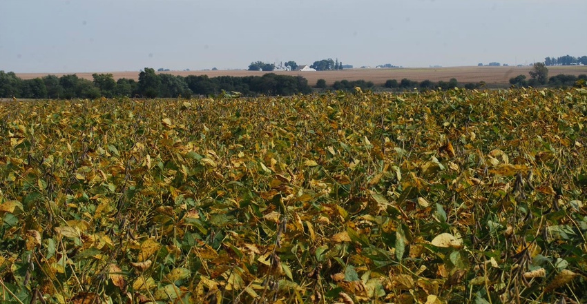
In some central Iowa fields corn husks are turning brown, but the kernels haven’t formed a black layer yet. That black layer forming in the tip of the corn kernels indicates when the corn plant has reached physiological maturity and is safe from frost.
Farmers in central Iowa tell Wallaces Farmer that corn husks are browning in many of their fields. “Our soybean plants are about a third shorter than what we consider normal,” says Jim Spencer, a Madison County farmer.
Spencer says the bean plants don’t have as many pods as they usually do. Also, there are a lot of weedy fields — waterhemp and button weed showing through in some fields. “There are weeds in fields that look like they didn’t get any herbicide at all, due to the wet spring,” he says.
USDA’s weekly statewide crop conditions survey released Sept. 9 rates Iowa corn condition at 63% good-to-excellent. Soybeans are rated 61% good-to-excellent.
“Near-seasonal temperatures along with the pattern of dry conditions continued across most of the state last week,” notes Iowa Ag Secretary Mike Naig. “With 4% of our corn and 15% of our soybeans nearing maturity, Iowa farmers are starting to prepare equipment for harvest.”
Nationally, USDA is pegging the amount at 89% of the U.S. corn crop that’s now in the dough stage, compared with 97% for a five-year average. Also last week, USDA said the mount of soybeans setting pods is at 99% for the U.S. crop. The complete weekly Iowa Crop Progress and Condition Report is available on USDA’s site at nass.usda.gov.
Crop report
Most of Iowa experienced cooler-than-normal temperatures and below-normal precipitation during the week ending Sept. 8, according to USDA’s National Ag Statistics Service. Statewide there were 5.7 days suitable for fieldwork. Fieldwork activities included harvesting hay and seed corn, chopping corn silage, seeding cover crops, and preparing machinery for corn for grain and soybean harvest.
Topsoil moisture was rated 5% very short, 26% short, 68% adequate and 1% surplus. Areas in 28 counties were rated as D1 moderate drought, according to the Sept. 3 U.S. Drought Monitor due to the persistent lack of rain in parts of Iowa. Subsoil moisture was rated 5% very short, 24% short, 70% adequate and 1% surplus.
Iowa’s corn crop is 91% in or beyond dough stage, two weeks behind last year and 12 days behind the five-year average. Also, as of Sept. 8, a total of 61% of this year’s corn crop has reached dented stage, two weeks behind last year and nine days behind average. Only 4% of Iowa’s corn had reached maturity, 11 days behind average. Corn condition is rated 63% good-to-excellent.
Iowa’s soybean crop is 94% setting pods, 18 days behind last year and nearly two weeks behind average. And 15% of the crop has begun coloring, 12 days behind last year and nine days behind average. Soybean condition rated 61% good-to-excellent.
The third cutting of alfalfa hay reached 76% complete as of Sept. 8, nearly a week behind average. Pasture condition declined from the previous week to 42% good-to-excellent. There were no livestock issues to report from this past week.
Weekly weather summary
Drier-than-normal conditions prevailed across most of Iowa during the first week of September. Rainfall deficits were generally under three-quarters of an inch across the state with only the southwest corner of Iowa reporting above average rain totals.
Temperatures were generally seasonable with departures of 1 to 2 degrees above and below average in parts of western and eastern Iowa, respectively. Statewide average temperature was 66.8 degrees, 1.8 degrees below normal.
That summary for the week ending Sept. 8 comes from Justin Glisan, state climatologist at the Iowa Department of Agriculture. He provides the following daily report, area by area.
Cooler than normal last week
To start the week, Sunday (Sept. 1) was uneventful across Iowa with high temperatures reaching mid-to-upper 70s under cloudy skies. Overnight lows into Monday dipped into the mid-60s. Partly sunny skies and a southerly wind helped boost temperatures into the low 80s on Labor Day.
Shortly after midnight on Tuesday, thunderstorms, some strong, formed in northeast Iowa and quickly moved into Illinois. More showers moved through Iowa during the late morning and afternoon, bringing measurable rain across Iowa’s northern half. Highest rain totals were in northeast Iowa with Lansing and Waukon (Allamakee County), receiving 1.53 inches and 1.34 inches, respectively.
Wednesday was a cool and mostly sunny day across Iowa. Highs were in the low 70s, up to 14 degrees below average at certain locations. Statewide average high was 74 degrees, 5 degrees below normal.
Thursday started off cool and sunny with comfortable conditions into the early afternoon before a low-pressure center over Minnesota pulled a warm front through Iowa. Arrival of the front brought warm and humid conditions through the evening hours before a cold front cleared the state into Friday morning. Winds shifted into a northerly direction under sunny skies. High temperatures peaked in upper 70s and lower 80s.
Saturday began mostly clear until showers moved through Iowa in the afternoon. Storms formed in southern Iowa during nighttime hours and lingered into Sunday morning. Rain totals at 7 a.m. were highest in southwest Iowa with Shenandoah (Page County), reporting 2.56 inches. Over 10 stations reported totals above 1 inch, with the statewide average rainfall of 0.41 inch.
Weekly rainfall totals ranged from no accumulation at multiple locations to 2.56 inches in Shenandoah (Page County). Statewide weekly average precipitation was 0.50 inch, while normal is 0.84 inch. The week’s high temperature of 92 degrees was reported on Sept. 3 in Donnellson (Lee County), 11 degrees above average. Elkader (Clayton County) and Manchester (Delaware County) reported the week’s low temperature of 45 degrees on Sept. 9, on average 7 degrees
About the Author(s)
You May Also Like


