Subscribe to receive top agriculture news
Be informed daily with these free e-newsletters

Here’s how to get started using an unmanned aerial vehicle to scout your crops.
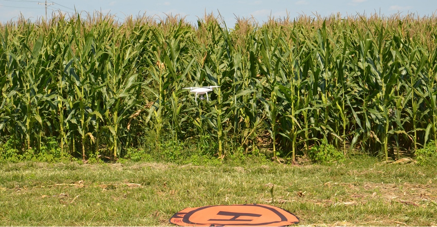
You’ve read about UAVs, commonly called drones, being used in agriculture for a couple of years now. If you think this is the best method for scouting your fields during the growing season, then you have work to do. Becoming familiar with an unmanned aerial vehicle and learning how to fly it and collect meaningful data is a process, Bob Nielsen says.
Nielsen is a Purdue University Extension corn specialist. He notes that technically, the Federal Aviation Administration’s designation for these tiny machines used in agriculture is sUAS, which stands for small unmanned aircraft systems.
He and Jim Camberato, a Purdue Extension soil fertility specialist, do research and on-farm trials together. They have both wished many times that they could see what was happening across an entire trial all at once, but they don’t have a reliable way to do that. They think UAVs may hold the answer.

Nielsen obtained his FAA remote pilot certificate this past summer. He and a visiting scholar from Ecuador, Ana Morales, began evaluating UAV photographs of field trials throughout Indiana.
“I’m excited about the potential they hold for getting information on crops when you need it, and getting it quickly,” Nielsen says. “We’re still learning how to operate them in various situations, but we certainly learned a lot about what crops were doing this season that we could not have seen just walking fields.”
12 steps
Here are 12 steps for flying a UAV successfully to scout crops, based on Nielsen’s and Morales’ experiences so far. Both emphasize that it’s a learning process.
1. Study for and obtain your FAA remote pilot certificate. Anyone using these aircraft for commercial purposes is required to get a remote pilot certificate. That includes farmers using them to make economic decisions on their farm. If you think you’re going to look at a book for half an hour and pass the test, you may be disappointed, Nielsen says. Study materials are available, both printed and online — most at a reasonable cost. “You really need to know some of the same things pilots know to fly safely,” Nielsen says. “You are the pilot of your drone.”
2. Select a UAV. Choose from a multi-rotor or fixed-wing model. Multirotors tend to be less expensive and more flexible to fly. Fixed-wings allow you to cover more acres per battery charge. Nielsen uses one of the DJI Phantom multirotor models, starting at about $1,400 with a regular camera. Other models are available at much less cost.
3. Decide how much digital image information you need. During his first year using the UAV, Nielsen stuck with a regular camera taking color digital images. Some people opt for cameras capable of infrared photography so they can generate Normalized Difference Vegetation Index images. That can add several thousand dollars to the price tag.
4. Make sure the UAV can handle the camera. If you’re adding an extra camera, such as one for obtaining NDVI information, make sure your UAV can handle it, and that you know how to mount the camera to the aircraft. If all parts aren’t compatible, you may have a UAV prone to crashing.
5. Understand the capabilities of your UAV. How many minutes can it fly on a single battery? How many acres can you cover in one flight? Many people find that because of weather conditions, they may not get quite as many minutes per flight as the manufacturer suggests. If you know the limitations, you know how to program the flight.
6. Cash in on your UAV’s advantages. Satellite and aerial services are also available to provide crop information. What can you do with your UAV that you couldn’t get from those services? “You can fly it anytime you decide weather conditions are fit,” Nielsen says. “Most services have set schedules. If it’s cloudy when they fly, you won’t get as good an image. If it’s cloudy and you have your own UAV, you can wait until skies clear.”
7. Understand the limitations of your UAV. If you have 100 acres to cover, you probably won’t fly it on one battery, Nielsen says. He suggests planning ahead and purchasing extra batteries. Some units are equipped with safety features that signal it to head back to the launch area if the battery is critically low.
8. Avoid other objects. Flying near trees and power lines isn’t recommended. Many units today also have built-in crash avoidance sensor technology. If the unit senses an object within so many feet, it will hover and won’t advance. “It will even hover above the corn and not go so low that it hits the crop,” he says.
9. Take wind speed into account. Understand what your user’s manual says about flying in windy conditions. One usual outcome is that the UAV runs out of battery faster in windy conditions.
10. Know why you are flying the UAV. What is it you want to learn? Early in the season over V3 corn, it may be to judge color and evenness of the crop. Near the end of the season, you may be looking for areas of nitrogen deficiency or stalk rot, Nielsen says.
11. Know how to pinpoint locations for ground-truthing. It’s important to georeference spots where you believe you need to take a closer look on the ground, Nielsen says. “That’s the value of ‘stitched’ whole-field images,” he says. Then you can walk directly to that spot and determine why it’s different than the rest of the field.
12. Choose how to use the data you collect. Flying manually allows you to shoot photos or video wherever you want. Flying with a planned flight mission results in hundreds of images taken automatically. They can be stitched together like a jigsaw puzzle to create a single whole-field image. You can buy software to stitch them, or you can subscribe to a service. Nielsen says such services are typically affordable and provide quick turnaround.
Decision Time: Production is independently produced by Farm Progress and brought to you through the support of Case IH.
You May Also Like
Current Conditions for
56°F
Mostly Cloudy
Day 73º
Night 54º
Enter a zip code to see the weather conditions for a different location.