Subscribe to receive top agriculture news
Be informed daily with these free e-newsletters

UAVs are good scouting tools now; advances in cameras and software allow farmers to make even better use of data collected.
November 22, 2016
I would just like to clarify some of the things UAVS are good at now and what is in development.
Right now, UAVs are great tools for easy general scouting taking photos and video. The smaller quadcopter UAVs can be in the air in minutes and have high-quality imagery to your phone or iPad in seconds. This is very helpful for finding troublesome spots in the field, nutrient deficiency, wet areas, weeds and anything else you can see from the air.

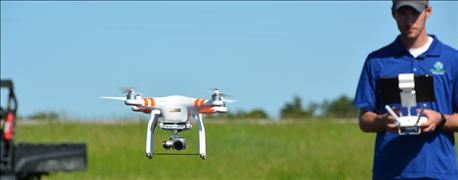
UP AND AWAY: A UAV takes off with Nolan Berg, Peterson Farms Seed precision ag specialist, at the controls.
The small quadcopter UAVs are now very capable of mapping fields. Software advancements have made it very easy to fly fields completely autonomously in a grid pattern across your field. While flying in this pattern, the UAV is taking many pictures that can be later uploaded into software that will stitch photos together into what is called an orthomosiac. An orthomosiac is very much like Google Earth but much more detailed when you zoom in for a closer look. Of course, the camera on these UAVs is just a regular color image, so the types of things a grower will see are comparable to the things the human eye can see.
This is where multispectral imagery comes into play. A significant recent advancement is the release of affordable, calibrated multispectral sensors. These sensors, with calibrated images, allow farmers’ maps to be compared over time. Because uncalibrated images can only be compared to themselves, these new maps allow farmers to track plant stress, diseases and nutrient deficiencies over a period of time.
Multispectral imagery has the potential to detect nitrogen deficiency before our eyes can see it. When utilizing hot streaks in fields, we can use the multispectral imagery in season to gauge if the rest of our field shows signs of deficiency compared to the N hot streak. In the past, symptoms would need to be visible to the naked eye, which means the damage had already occurred. With the calibrated multispectral technology, farmers are able to detect and react earlier, thus preserving yield.
Software advancements in interpreting the imagery are also getting better. Companies are putting a lot of time and effort into figuring out what to do with the collected data. I believe the next step in the evolution of UAV utilization in agriculture will be to streamline the data into an application map for a sprayer, sidedressing units, planters, ditching and tillage equipment. The faster we can collect the data and then interoperate the data correctly into an actionable application, the more we can preserve yield and be more efficient on the farm.
Berg is a Precision Systems specialist with Peterson Farms Seed, Harwood, N.D. For more information about UAVs and precision farming, and about Peterson Farms Seeds use of the technologies, contact him at 866-481-7333 or [email protected].
You May Also Like
Enter a zip code to see the weather conditions for a different location.