Subscribe to receive top agriculture news
Be informed daily with these free e-newsletters

Check out this week's gallery of weather related maps to see what has been happening in the Midwest.
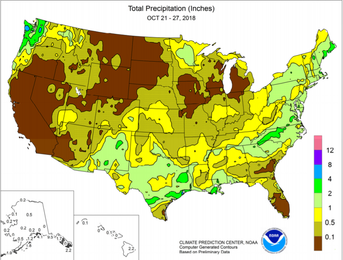
Many farmers are finding the 2018 harvest challenging. Just as they think they are beginning to catch up, the dreaded rain or snow begins to fall again. This is making fieldwork difficult to say the least. An extended period of mostly dry weather across the northern and central Plains and the Midwest allowed the 2018 harvest to gain momentum. However, late -week showers ended that fairly quickly. The weather woes aren't just in the Midwest. Late-week showers also increased in
intensity from the Pacific Northwest to the northern Rockies. Although the heaviest precipitation fell in coastal and mountain locations, some Northwestern winter grains benefited from a boost in topsoil moisture.
The southern Rockies also received significant, drought easing precipitation, but mostly dry weather persisted in California and the Great Basin. In addition, near or above-normal temperatures dominated the West and the
northern Plains.In contrast, weekly temperatures averaged at least 5°F below normal across much of the South, East, and lower Midwest.
Lingering Southern warmth was limited to Florida’s peninsula.
At week’s end, a coastal storm delivered heavy rain and gusty winds to the middle and northern Atlantic States, while some interior Northeastern locations received snow.
Summer-like warmth lingered across southern Florida, where daily-record highs rose to 91°F in Miami and West Palm Beach. In contrast, October 21 featured daily-record lows in Illinois. Meanwhile, Eastern high temperatures failed to reach the 50-degree mark in many places on several days.
Check out the gallery to see a collection of weather related maps.
You May Also Like
Enter a zip code to see the weather conditions for a different location.


