Subscribe to receive top agriculture news
Be informed daily with these free e-newsletters

Exceptional drought hits Wabaunsee County as east-central Kansas continues to experience severe drought.
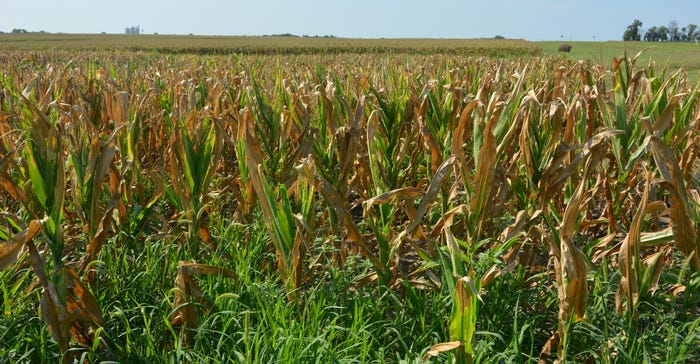
NO EARS: This corn field, hard-hit by drought in June and July, did not produce ears. Very little green is left on the corn stalks, though weeds have greened up in the wake of more recent showers.
Drought conditions continued to worsen in Kansas with the July 19 U.S. Drought Monitor map showing southern Wabaunsee County dropping into the worst category, exceptional drought.
More than half of the state is in at least moderate drought, with the hardest hit areas in east-central Kansas, although parts of Johnson, Wyandotte and Douglas counties, as well as Cherokee and Labette counties, also worsened to extreme drought.
All or parts of Harvey, Marion, McPherson, Chase, Dickinson, Saline, Morris, Lyon and Geary counties remained in extreme drought.

In Marion County, farmer Paul Penner says some fields of corn have mostly unfilled ears, although other fields nearby that maybe caught one or two timely showers from pop-up thunderstorms are in better shape.
There have been thunderstorms and showers across the state, but like most summer storms, they tend to produce heavy rain in a small area rather than the widespread rains that come with frontal storm systems.
"We finally got 3 inches this week at Hillsboro. At the home farm, I got a little over an inch," Penner says. "My land up around Tampa got less than half an inch."
Fields only a mile or two apart show vast differences in corn stress. Some fields have been chopped for silage already, with only a few strips of rows left standing for the crop adjuster. Others are still green with long, healthy ears, and even multiple ears in many cases.
More good news is that other fall crops, including soybeans and cotton, which have not reached the critical bloom stage, are in much better shape, even in drought areas.
Penner says one of his fields on the home farm held out until about mid-July and developed some ears before giving up to the drought.
"I drove up and got out of the pick-up and it smelled like I’d just cut hay," he says. "That was the smell of the leaves giving up."
Penner says he will still harvest that field but won’t get much yield.
With temperatures in the upper 90s and low 100s, even an inch of rain doesn’t last long, especially with fall crops continuing to grow in areas that have had rain. If history is any indication, the heat is likely to continue. Kansas typically has its hottest weather in the last half of July through the first week of August.
"It can cool down anytime now and I’ll be happy," Penner says.
The 30-day long-range forecast from the Climate Prediction Center indicates that Kansas will see another month of above-normal temperatures and below-average rainfall. The three-month forecast is also not encouraging, with most of Kansas forecast to see above-average temperatures for the next 90 days, and the eastern half of the state forecast to see below average precipitation.
The winter forecast looks somewhat better, with Kansas forecast to see above-average temperatures and above-average precipitation as the likelihood of an El Niño increases.
The Climate Prediction Center says current El Niño neutral conditions are expected to last through the summer, with odds of an El Niño increasing to 65% during the fall and 70% during the winter of 2018-19. El Niño conditions are associated with warm and wet conditions across the Southern Plains.
You May Also Like
Enter a zip code to see the weather conditions for a different location.


