Subscribe to receive top agriculture news
Be informed daily with these free e-newsletters

Welcome rains soak much of Kansas, but exceptional drought still grips east-central region.
The areas of eastern Kansas in extreme or exceptional drought grew slightly as depicted on the Aug. 2 U.S. Drought Monitor Map maintained by the National Drought Mitigation Center at the University of Nebraska-Lincoln.
Rains, some of them heavy, did move across parts of the state during the last week of July, but frustrated farmers and ranchers in the hardest-hit counties of Wabaunsee, Lyon and Morris in the heart of the Flint Hills watched helplessly as storm after storm fell apart before reaching the region.
Most of the eastern half of the state — usually the region that gets the most rainfall — remains in at least moderate drought, with a finger of extreme drought in the central region and another patch of extreme drought in the far southeast corner in LaBette and Cherokee counties.
The western half of the state has been blessed with unusual amounts of rainfall during the last couple of months and remains drought-free.
The much-watched El Niño Southern Oscillation remains neutral this summer, with odds rising that an El Niño will develop in the fall or winter. The odds are now at 65% for a fall-developing El Niño and 70% for a winter event. El Niño is typically a winter event, characterized by warmer-than-normal water temperatures in the Equatorial Pacific.
Strong El Niño events have been associated with warmer, wetter winters across the Southern Plains because of a shift in the jet stream. During El Niño, the jet stream enters the Pacific coast across southern California.
The weather forecast for the short-term is not promising, showing above-average temperatures and below-average precipitation for the eastern half of the state into October.
The long-range forecast from the Climate Prediction Center is more promising, showing above average temperatures and above average precipitation for all of Kansas from October through the end of the year.
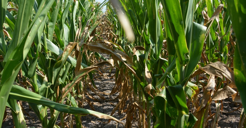
A blistering hot June and July with only spotty showers took a heavy toll on the corn crop in the affected region, even though soybeans and cotton were looking very good at the end of July.
It’s been a struggle of a grazing season for ranchers in the bone-dry Flint Hills, with many ranchers having to haul water to pastures.
At the end of July, the Division of Conservation at the Kansas Department of Agriculture is pleased to announce the availability of funds to assist landowners with their efforts to mitigate the impact of drought. The Livestock Water Supply Financial Assistance Initiative will provide financial assistance for livestock water supply wells, pipeline and tanks installed after June 1, and before the announcement of the Environmental Quality Incentives Program Drought Initiative by NRCS on July 24.
The State Conservation Commission took action on July 31 to approve the initiative for these qualifying drought mitigation efforts that took place prior to the NRCS EQIP Drought Initiative. Eligible areas will be the same as for the federal initiative.
Additional program details can be found at agriculture.ks.gov/DOC-assistance. Applications must be made through local conservation districts, and questions should be addressed to local conservation districts as well. Contact information for districts can be found at agriculture.ks.gov/conservation.
You May Also Like
Enter a zip code to see the weather conditions for a different location.


