November 25, 2019

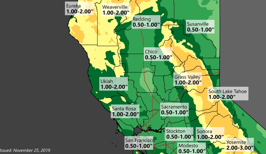
The season's first significant storm is about to plant a big, wet Thanksgiving kiss on the parched West Coast beginning Tuesday, bringing as much as an inch of rain to California's Central Valley while dumping copious amounts of snow in the Sierra Nevada.
Another system could come to the region next weekend, according to the National Weather Service in Sacramento.
The storms mark a much-needed change in the weather pattern after more than a month of warm, dry and windy conditions throughout the state fueled wildfires and prompted Pacific Gas & Electric Co. to impose a series of planned blackouts to avoid sparking more fires.
As a strong Pacific system reaches the West Coast, rain and snow will develop Tuesday afternoon, with heavier precipitation seen Tuesday night, according to an NWS advisory. The heaviest for the Sierra should be between 4 pm and 10 pm.
Rain and snow continue Wednesday into Thursday with a chance of thunderstorms both of these afternoons, the agency predicts. Snow levels could drop as low as 1,500 feet in some areas, or even lower in parts of Shasta County, according to the weather service.
Valley rainfall may cause minor flooding due to clogged drains, given it has been several months since the last widespread rain. The weather is expected to become more showery on Thanksgiving Day and light snowfall could continue through Friday morning with below-average temperatures and low snow levels, the agency reports.
Up to 2 inches of rain
The storm could bring up to 2 inches of rain to the Northern California coast and an inch to the inland valleys, while dumping as much as 4 feet of snow on mountain peaks, the weather service forecasts.
The federal Climate Prediction Center foresees above-average precipitation throughout California and the southwestern U.S. over the next two weeks, with the Central and Southern California coastline potentially seeing rainfall that is well above average.
A series of storms would provide much-needed relief as many areas have yet to see rainfall this fall. In the water year that started Oct. 1, Sacramento has recorded but a trace of rainfall; the city has normally seen an average of 2.52 inches of rain by Nov. 25, according to the NWS. Fresno has recorded no rainfall since Oct. 1; its average as of Nov. 25 is 1.47 inches.
Farmers in the western San Joaquin Valley were alerted Monday to a potential freeze Tuesday morning, with minimal temperatures dropping as low as 28 degrees in some areas. The storm is expected to push the valley's lows into the 40s, but temperatures could dip down again Friday night, the NWS predicts.
Tuesday's storm is expected to also dump heavy snow on parts of the Pacific Northwest, with blizzard-like conditions in Oregon and Northern California, the Reuters news service reports. Dozens of winter storm watches and warnings are in effect throughout the western U.S., the wire service notes.
To view a video briefing about the storm from NWS officials in Sacramento, click here.
About the Author(s)
You May Also Like


