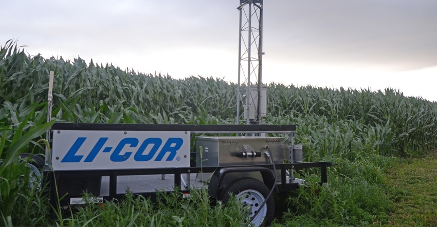
How do you define a watershed? For different purposes, it can mean different things. For one group of stakeholders in Nebraska, defining a closed watershed is the first step in measuring and managing a how much water is used in a given area.
For some, the watershed could be an entire natural resources district (NRD). For others, it might be a hydrologic unit code (HUC) with 8, 10 or even 12 digits — the more digits, the smaller and more precisely defined the watershed. For this group, which includes members of the Nebraska Water Balance Alliance (NEWBA), Upper Republican NRD, University of Nebraska Extension, Nebraska Department of Natural Resources (NDNR) and irrigators in western Nebraska, it will likely include both large and small watersheds.
“Ted Tietjen [project coordinator at the Nebraska Water Balance Alliance] is advocating for managing our resources on a watershed-wide scale,” says Daran Rudnick, a Nebraska Extension ag water management specialist and one of the project collaborators. “The idea is to have a better idea of the consumptive use of different agro-ecosystems — including rain-fed and irrigated production and natural vegetation — and be able to account for where that water is going.”
Tietjen notes after NEWBA collects quality data on different crops and plants from small watersheds — HUC 12s in western Nebraska — the alliance plans to transfer that data to larger watersheds — HUC 8s like the Stinking Water Creek in southwest Nebraska.
“The larger sub-basin is large enough that management strategies can be developed to better preserve aquifers, provide stream flow and a healthy ecological environment,” explains Tietjen.
Ultimately, Extension hopes this research will provide growers information to help with irrigation decisions and give them a full picture of a water budget.
Checkbook math approach
It starts with measuring consumptive use of water for the watershed using a checkbook math approach. This includes inputs in the form of precipitation, as well the main output, evapotranspiration (ET). So, the project will use a network of weather stations to keep track of precipitation, as well as soil moisture probes to monitor water in the soil profile. Completing the equation, however, requires measuring ET.
This is where Li-Cor’s eddy covariance towers come in. There is currently one eddy covariance tower installed in western Nebraska as part of the project, but Rudnick hopes to install a second tower. As wind flows over the surface of the Earth, turbulence is created, and that turbulence consists of eddies. Li-Cor’s flux towers simultaneously measure the wind velocity, gas concentration and temperature of those eddies as they transport carbon dioxide and water vapor from the atmosphere to the surface, and from the surface to the atmosphere, measuring the “flux” of water vapor and carbon dioxide that’s leaving and returning. Measuring the water vapor that’s leaving gives a direct, more accurate measurement of ET.
“We’re measuring CO2 flux, water flux, energy flux and variables for weather calculations,” explains Dayle McDermitt, former Li-Cor vice president for research and development, environmental products and now an adjunct professor in the University of Nebraska-Lincoln's Department of Agronomy and Horticulture. “The fundamental idea is to be able to actually measure ET and combine measured values with remote sensing models, and then use the combination of models and ground-truthing ET measurements to get accurate ET information out to stakeholders, so they can use it.”
Take a direct measurement
With a direct measurement of ET, there’s not only a true measurement of water use over a given area, but there’s also an accurate measurement that can be used to validate crop coefficients, which are used to estimate a crop’s ET by adjusting reference ET that is calculated from weather stations. Crop coefficients are often used by growers for ET-based irrigation scheduling, but most coefficients are based on a single adjustment factor — the difference between the hypothetical crop that’s being used as the reference, and what’s actually going on in the field.
Plant hardiness zones, growing degree days, soil types, hybrids and varieties, and residue management practices change in different regions — and all affect ET. Rudnick hopes with a direct measurement and by accounting for more factors through weather stations and soil moisture probes, they can get a more accurate representation for specific localities — and get a more complete picture of the water budget. Ultimately, he notes, this helps provide growers with timely, accurate, local data for growers to improve irrigation practices, and keep track of how those decisions influence the water budget of a given area.
“That’s what’s nice about having multiple forms of information,” says Rudnick. “If you’re using a soil moisture sensor and it’s taking an indirect measurement, it’s not perfectly accurate, but it’s telling you that you have 60% of your profile with available water. If you’re using an ET calculator using a direct measurement, you could run a water budget, and know whether it overestimated or underestimated how much water is in your soil profile.”
Currently, the project is unfunded, but Rudnick notes they are looking for interested groups to work with growers involved in the project to use various sensors.
To learn more, contact Rudnick at [email protected].
About the Author(s)
You May Also Like


