April 16, 2020

Annual measurements show an average change of -0.62 of a foot in groundwater levels of the Ogallala/Edwards-Trinity (High Plains) Aquifer from 2019 to 2020, according to findings from the High Plains Underground Water Conservation District (HPWD).
“The amount of rainfall and its timing during the growing season can significantly impact the amount of groundwater pumped from the Ogallala/Edwards-Trinity (High Plains) Aquifer each year,” says HPWD Field Technician Supervisor Keith Whitworth. "The largest water level rise was 5.64 feet in a Hockley County well and the largest water level decline was -8.32 feet in a Castro County well."
The 10-year (2010-2020) district average change is -7.85 feet while the five-year (2015-2020) district average change is -2.16 feet. The average saturated thickness of the Ogallala/Edwards-Trinity (High Plains) Aquifer within the District is 55 feet (2019-2020).
Water Measurements
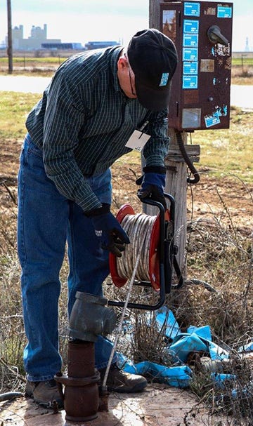
 (HPWD Field Technician Supervisor Keith Whitworth makes a water level measurement in one of the 1,345 privately-owned wells in the District's observation well program. Photo by HPWD)

Starting in January, HPWD field personnel made water level measurements in a network of 1,345 privately-owned water wells completed into the Ogallala/Edwards-Trinity (High Plains) Aquifer. In addition, annual measurements were also made in 31 Dockum Aquifer wells. These wells showed an average change of -0.61 of a foot (2019-2020).
The portion of Armstrong County within the HPWD service area had an average increase in water levels. The other 15 counties recorded average declines, according to Whitworth.
The 2019-2020 statistics for Ogallala wells with publishable measurements are as follows:
336 observation wells with increases ranging from 0.1 to 5.64 feet.
617 observation wells with decreases ranging from 0 to -.99 of a foot.
258 observation wells with decreases ranging from – 1 to -1.99 feet.
65 observation wells with decreases ranging from -2 to -2.99 feet.
30 observation wells with decreases ranging from -3 to -3.99 feet.
14 observation wells with decreases ranging from -4 to -4.99 feet.
10 observation wells with decreases ranging from -5 to -8.32 feet.
Results of the 2020 water level measurements and updated saturated thickness information are now available on the interactive map on the HPWD website (map.hpwd.org). For printed information of water level measurement data for individual counties, contact Jed Leibbrandt at (806) 762-0181 or email him at [email protected].
Dockum Aquifer observation well information is also available on the HPWD website (dockumstudy.hpwd.org).
“This recent addition to the website includes water level data in observation wells, study wells, and wells equipped with pressure transducers,” said HPWD General Manager Jason Coleman. “It also features drillers and geophysical well logs for Dockum Aquifer wells, water quality data, and flow test information,” he said.
Infographic summaries about the 2020 Ogallala/Edwards-Trinity (High Plains) and Dockum Aquifer water level measurements are available at www.hpwd.org/reports
www.hpwd.org.
Source: is HPWD, which is solely responsible for the information provided and is wholly owned by the source. Informa Business Media and all its subsidiaries are not responsible for any of the content contained in this information asset.
About the Author(s)
You May Also Like


