Subscribe to receive top agriculture news
Be informed daily with these free e-newsletters

Drone-use pitfalls can include a frozen tablet, a tablet which didn’t charge, a connection failure, and an over-ambitious flight plan.
May 8, 2017
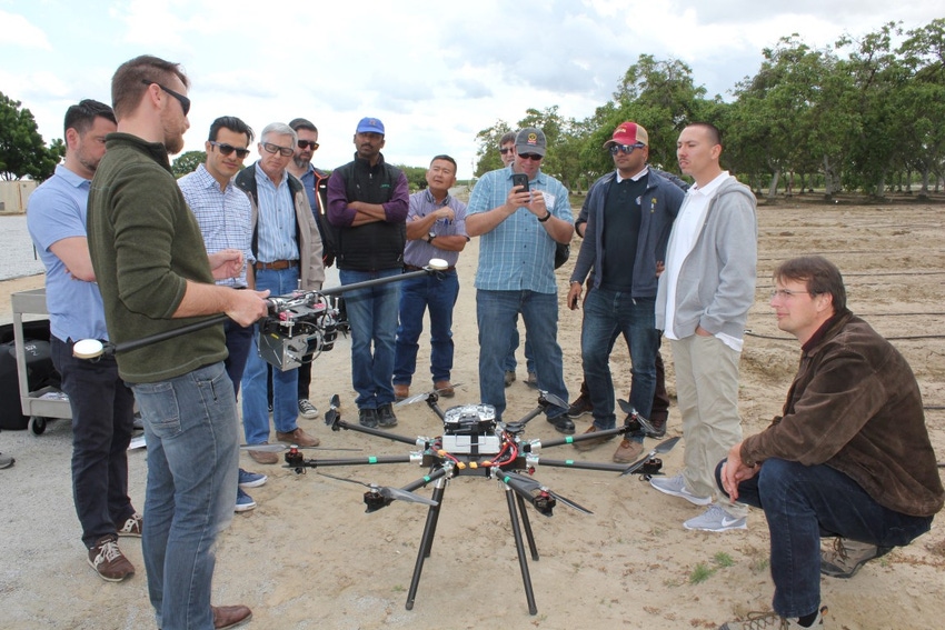
Hail cannons boomed as participants at a drone workshop stepped outside a classroom at the Kearney Agricultural Research and Extension Center at Parlier, Calif. for hands-on instruction on how to pilot an unmanned multi-rotor copter.
The center is, after all, in the heart of the nation’s tree fruit industry, and the gathering clouds and unsettled weather held off just long enough for most workshop participants to guide a craft through the air and to safe landings.
Some of the information presented at the workshop and a second one the next day drifted into the highly technical and esoteric, but the emphasis was on the practical.
“Not novel gazing,” said Sean Hogan, academic coordinator for the University of California (UC) Infomatics and GIS Statewide Program.
Safe landing first
Hogan’s emphasis was on flying successfully and bringing unmanned aerial craft in for a safe landing, avoiding costly crashes. Stressing attention to detail, he said, “It helps to have a healthy case of OCD (obsessive-compulsive disorder).”
Participants in the classes included UC farm advisors and researchers, students, and others in the agricultural community.
Michael Moriyama, grower relations field representative with Sun-Maid Growers of California, explained the cooperative is interested in taking pictures of growers’ farms for use at workshops. He also wanted to know others ways how drones could be used.
Others included colleagues Drew Palrang, station scientist with the Bayer CropSciences (BCS) Fresno Research Technology Station, and James McNutt, BCS’ senior technical services representative in the northern San Joaquin Valley.
Palrang said Bayer hopes to use drones to monitor crops for health benefits from the application of Bayer products. He was especially interested in multispectral technologies.
Agriculture - 19 percent drone market
Hogan said there has been “a major push in the number of drone licenses,” and drones for agriculture rank third in the Federal Aviation Administration’s (FAA) forecast for top markets for their use.
Agriculture is expected to have 19 percent of the drone market, behind industrial inspection at 42 percent and real estate photography at 22 percent.
Hogan discussed two drone platforms – fixed-wing craft that typically can carry more of a payload and fly for a longer time period; and multi-rotor copters which cost less, take off and land vertically, and have shorter flight times.
He said a drone can cost as little as $180 and then be outfitted with a camera costing $3,500, or be outfitted with a lower cost Go-Pro, but it has the drawback of no geo-tag feature telling where a photo was taken.
As to the price and feature differentials, Hogan said, “You get what you pay for.” Deciding what to buy depends on what the drone will be used for and, of course, the purchaser’s budget.
Drones can be used in agriculture for a variety of purposes, including pesticide application, crop health status, determining moisture level and water use efficiency, plus fire monitoring, rangeland assessment, and forestry modeling.
Drone use pointers
Hogan discussed components to launch, fly, and retrieve drones, including tablets and apps. He said desirable features include a fast processor, solid construction, a bright 8-10-inch-sized screen, and a minimum of 16MB RAM.
Hogan and others shared pointers on tablet use, and other steps to fly safely. Keep the drone tablet clean and install only the apps needed. Also, avoid apps that constantly download, and install updates before the flight day. Hogan recounted an experience of a flight disrupted as his tablet sought to download updates.
He cited mission planning and automated flight apps including Tower, Drone Deploy, Pix4D Capture, and SiteScan (3DR). Flight planning software includes Pix4D.
Your friend - Google
As to getting help on drone research, Hogan said, “Google is your friend” and can be used to gather information online. There are also web addresses to prepare the user for commercial licensing and to gather further information.
Sensors typically fall into three categories: digital cameras, LIDAR, and thermal imagers.
Multispectral cameras cost between $740 and $3,500. LIDAR technology is best for complex measurements of tree canopy structures, and a high-quality system costs about $50,000. Thermal imaging is used to detect moisture, fires, and for search and rescue. These units start at around $6,700.
Drone users should have five to seven batteries charged before flight day to get the most out of their time. They should watch for unexplained battery drain. Beware of bubbles or bulges on batteries. Hogan cited a landing that resulted in a grass fire due to a battery malfunction.
Drone users should allow enough time for the drone to make a safe return, keeping an eye on displayed battery usage. Start your ‘return to home’ any time the battery gets down to 25-30 percent.
‘Murphy’s Law’
Referring to “Murphy’s Law,” Hogan said something as simple as “an evil strand of grass” can be problematic. He said the propeller on a drone caused a strand of grass to bind up and stop the craft. Bumping the joystick can also be a problem.
Hogan recounted a drone landing when a dog tried to eat the drone. “Keep it away from animals,” he noted.
In another instance, the pilot accidentally turned off the controller. Hogan said pilot error is the leading cause of crashes. A pilot also accidentally hit the “pause flight” button.
High winds at altitude can be a problem. Hogan recommends using an anemometer to check wind speeds.
Other pitfalls can include a frozen tablet, a tablet that didn’t charge, a connection failure, and an over-ambitious flight plan. A memory card can be corrupted.
Hogan recommends a systematic routine of checking – in order – the controller, the drone, and the tablet before each flight. It can take four hours to make all the preparations for a 20-minute flight.
A camera can be out of focus, and the user could forget to remove the lens cap. Make sure the camera is turned on and pointed in the proper direction in preparation for the flight. Turn the camera up and forward before landing.
Take-offs – and often landings – should be made from a level area, perhaps a sheet of plywood to cut down on dust. The lithium ion-polymer batteries used with drones are prohibited on all airlines.
Drone regulations
Andy Lyons, statewide program coordinator for UC Infomatics and Geographic Information Systems, discussed drone regulations and getting a commercial license if a drone is used in any money-making venture or if it was purchased by UC with grant money.
There is ample information on the internet concerning the Remote Pilot License FAA exam (Part 107).
Among FAA concerns is drone use can impair other aircraft. Drones are prohibited from flying near emergency response efforts including fires, within five miles of airports, and over groups of people, stadiums, or sports events.
Although it’s not necessary to take a class prior to testing, a daylong class is offered through UC Merced Extension for $300. There’s also a Drone Pilot Ground School online course for the same cost at http://www.dronepilotgroundschool.com/.
Drone links, regulations
An alphabet soup of internet links can be searched to gain information on drone use and the related regulations.
Search the www.youtube.com website for various webinars to prepare to take the FAA Rule Part 107 test.
Visit the Federal Aviation Administration (FAA) webpage at https://tinyurl.com/hz95ekk on how to become a pilot.
Study guide for the FAA exam - https://3dr.com/faa/study-guides/
FFA exam FAQs - https://www.faa.gov/uas/faqs/
Registration information - https://registermyuas.faa.gov/
Exam preparation resources - https://www.faa.gov/uas/
You May Also Like
Enter a zip code to see the weather conditions for a different location.


