

Subscribe to receive top agriculture news
Be informed daily with these free e-newsletters

Extension educators around Indiana are using unmanned aerial vehicles for various purposes, working with farmers and rural residents.
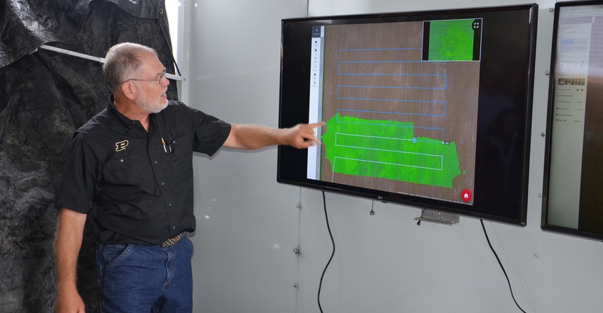
Bob Nielsen and Jim Camberato have made it a point at field days this summer to demonstrate how they use unmanned aerial vehicles to scout fields. Wherever they go, they bring their mobile display and set up large screens, so people can see what the UAV sees.
“It’s exciting technology, and we’re helping people get used to it,” says Nielsen, Purdue University Extension corn specialist. Camberato is a Purdue Extension soil fertility specialist. Recently, the two specialists flew their DJI Mirage UAV over field-scale trials on sulfur on Ken Simpson’s farm near Morristown, Ind. People could watch on a screen what the UAV saw from the air.
Advances in technology make this capability more meaningful, Nielsen says. Today, drones like the one he and Camberato fly stitch images on the go. As the machine takes hundreds of pictures, the operator sees a stitched-together image of the field form on the screen, showing both good areas and trouble spots.
Once the flight is over, it’s important to upload data to the cloud if you’re using a service like DroneDeploy to get better resolution of the image. There are also software options available that allow you to do this on your own computer.
Purdue Quad Squad
“One thing we’re learning is that in rural Indiana, you may not have access to fast internet to upload images for final stitching,” says Scott Gabbard, Shelby County Extension educator. He’s a member of the Purdue Extension Quad Squad, which formed recently.
“An option for educators is to take the data back to the Extension office and upload it there. Otherwise it can take a long time to load,” Gabbard notes.
Jason Henderson, director of Purdue Extension, bought 17 UAVs and distributed them to educators across the state who expressed interest in learning more about how aerial images could help farmers and others.
“Many were watching what Bob Nielsen was doing using UAVs to fly over his trials and became excited about the possibilities,” Henderson says. “It was a good investment so our educators can learn on their own, be ready to answer questions from farmers and assist farmers who have their own UAVs in interpreting results.”
Gabbard already had access to a UAV bought by the Shelby County Ag Promotion Committee, but he is a member of the Quad Squad. Mark Carter, Delaware County Extension ag educator, is state coordinator for the project. He notes that educators are using UAVs for more than scouting crops and research trials.
Some in southern Indiana are finding them useful for working with people who have timber. Others are beginning to work with county officials or other agencies on projects where it’s important to have aerial images before a project begins and as it unfolds.
Gabbard and Carter are adamant about one point. “If you’re going to own a UAV and fly it over your fields, you need to educate yourself and pass the FAA Part 107 licensing exam,” Gabbard says. “The moment you use what you see to make a commercial decision, even over your own fields, it’s no longer a hobby, and a license is required.”
You May Also Like
Enter a zip code to see the weather conditions for a different location.


