

Subscribe to receive top agriculture news
Be informed daily with these free e-newsletters

Sure farmers are gamblers, but we're talking tech and how the CES has become a place where ag tech is sneaking in too. Oh and there's a drone swarm video
January 10, 2018
No, I'm not writing this column from the confines of a hotel room along the Las Vegas strip, though I wish I was. I'm looking at some of the tech news from CES 2018 from afar. Interestingly, I'm seeing ag-related information show up too - perhaps not couched as ag but ag relevant. Drone technology and the Internet of Things keep advancing.
Farmers see the value of these high-resolution image gathering tools as an opportunity to improve crop management on a number of levels. We came across two announcements from companies that offer drone tech for ag and other industries.
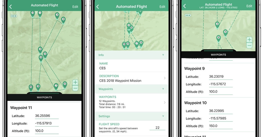
Kittyhawk, the long a drone innovator, announced this week that it was adding new features to its Flight Deck platform. The new feature provides automated flights to allow users to plan missions in the Kittyhawk mobile application and then execute the entire flight from takeoff to landing with unlimited waypoints.
The app does incorporate a range of safety features to ensure that you're not going to fly that drone to a place beyond the range of the radio and drone. Kittyhawk notes the example of someone trying to launch a drone in New York from their armchair in California. The software uses geolocation of the operator to show only flights that are possible to complete.
Kittyhawk reported that the new automated flight path feature is complements the recently released multi-channel secure live video and audio streaming feature. With this system there are a number of opportunities for improved flight monitoring too. The company offers examples of law enforcement or the film industry using the automated flight path. But farmers with irregular fields would benefit from this tool as well, just load the map, set the waypoints and a few other parameters and start capturing data.
This new system joins a list of Flight Deck tools including pre-flight, inflight and post-flight features like weather forecasting, risk assessments, flight profiles, live air traffic, secure data encryption, secure and secure domestic cloud coverage. Learn more at kittyhawk.io.
The internet of things
You've heard talk of connected sensors that could offer better in-field, real-time information. A number of companies are working on these tools, but there are some challenges like a common network standard and more. Senet has been a leader in providing cloud-based software and network support for Internet of Things applications.
At CES, Senet and Tracknet shared an interoperability and roaming demonstration showing off Tracknet Tabs - which is a consumer solution for tracking people and items using Senet's public Low Power Wide Area Network platform. This system works with what's called Long Range Wide Area Network - or LoRaWAN, and this demonstration was a first using the recently release LoRaWAN specification.
For farmers LoRaWAN tech allows for low-cost information capture from the field using cheaper sensors that use this "free" network standard to send information to a central hub. Senet has an established product line of these hubs that then move the information to the cloud. Instead of having a cell modem attached to every sensor, the LoRaWAN sensor uses radio waves to move information from field to the cloud. The only cell modem (and data charge) is for the central hub. This is a cost savings, but also supports the idea of more sensors in field, providing improved real-time information too.
The LoRaWAN systems are gaining traction especially as more standards are set. In announcing the Senet, Tracknet demonstration the companies emphasize that this technology won't work without standardization, ecosystem strength, and scalable, cost effective network coverage. It's an exciting area where a farm could have multiple sensors - for moisture, temperature, evapotranspiration, and other uses reporting to the cloud to provide real-time information from the field.
Wide implementation of this tech is coming, and new standards help. You can learn more about the tech at Senet's website.
And for a little fun
Intel, the chip maker, has been playing with drones as well. The company has developed "swarm" software that allows a single operator to control multiple unmanned aerial vehicles, and during CES the company held a demonstration indoors. You read that right, the drone swarm performed indoors using the latest mini-drone from Intel.
Called the Shooting Star Mini, it's a baby to big brother Shooting Star that got fame at the 2017 Super Bowl when a drone swarm performed for the half-time show (actually taped before the event because you can't fly drones over a crowd). The Shooting Star Mini uses the same Intel software for swarm management and is great for performances. But consider the potential of flying a half-dozen drones across your farm at once to gather information - it's possible. Watch the video below to enjoy the Shooting Star Mini show.
You May Also Like
Current Conditions for
51°F
Partly Sunny
Day 52º
Night 36º
Enter a zip code to see the weather conditions for a different location.


