November 22, 2019

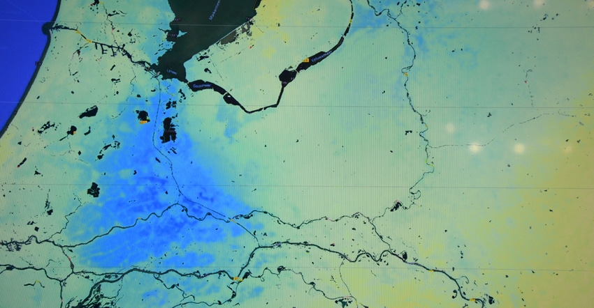
Satellite images can share a lot of information, but what are you really seeing? A new satellite imagery business called VanderSat, based in the Netherlands, is advancing a new approach to image capture that offers enhanced resources for farmland management.
“We’re providing higher-resolution imagery that is showing more detail,” says Robbert Mica, co-founder and chief marketing officer, VanderSat.
The system is using microwave imagery from satellites to capture soil moisture levels, crop temperature — and even the index of how much water is in a standing crop. Mica notes that a farm drought is more complicated than simply lack of rain. In fact, there can be areas that are fine with less rain in some parts of the year due to the soil moisture-holding capacity of the land, while others suffer faster when the weather dries. This system can see all of that.
In addition, the ability to capture soil temperature can help with decision-making, too, which Mica says will help with water management as well. The VanderSat system could help with refining irrigation scheduling models since it provides the high-resolution imagery for farmland daily.
The service originally started with the insurance industry, which needed more information when it came to financing or insuring crops in different areas. “We work with Rabobank, and if they want to finance a farm for the first time, they need information,” he says. “We can go back to 2002 and look at a time series of moisture for any field. We also have NDVI imagery back 16 years."
That’s valuable information for a banker laying off risk on crop yield estimates for the future. But for farmers, having that same information can be valuable in managing resources like water, too. Knowing how a field performed, given specific conditions, can help fine-tune water use in new ways.
Bye-bye, clouds
One issue that many farmers may raise is that satellite imagery can be useless on a cloudy day. Not for VanderSat. The satellite spectrum the company uses, combined with proprietary software, allows it to provide cloud-free near differential vegetative index (NVDI) maps daily, Mica says.
“We are finishing our work in cloud-free NDVI,” he says. “But it works.” And he demonstrated the images to Farm Progress at Agritechnica in November.
Showing an NDVI map of an area of Africa as an example, there were several areas blocked out. “That’s what it looks like with clouds,” he says. Then, he slides a bar on the screen, and NDVI imagery from the entire region shows up.
The company has partnered with several entities including Swiss Re, a reinsurance firm; Rabobank; and even Xarvio, the digital farming arm of BASF. “We’ve been in business for four-and-a-half years,” Mica says. “We’re usually in the back end of the process, and people don’t see us in public.”
A co-founder of the firm came from academia, where he found it stifling to do what he wanted, so he teamed with Mica to form the company and put satellite imagery ideas to work. The result is VanderSat — with imagery that could one day help a lot of farmers fine-tune their farm resource use.
You can learn more about the imagery the firm offers at vandersat.com.
About the Author(s)
You May Also Like


