Subscribe to receive top agriculture news
Be informed daily with these free e-newsletters

TerrAvion moves into region promising big results
As high-tech agriculture continues to develop, Mid-South producers have expanding options on how to get involved. The latest company to reach the region: TerrAvion, a Cloud-based aerial imaging and data analytics service.
Brian Hobson, who lives in Pope, Miss., is TerrAvion’s point man for the expansion. “I grew up farming, went to college in Arkansas and got an ag business degree. I came home to farm and then transitioned over to ag sales – both precision ag and equipment.
“TerrAvion is an aerial image provider. Our pixel size is smaller than any other on the market.
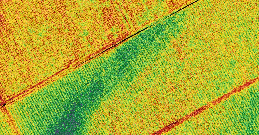
What can be gleaned from the images?
Natural color.
“That’s what you’d see with the naked eye from a bird’s eye view.
“NDVI is a growth vigor index that shows which parts of the field – in eight-inch square shots -- are vigorously growing. You can use it for scouting and go to the spots in the field not vigorously growing to find a remedy. Is it a pest? Is it nutrients? Too much or too little water?
“The image lets you find problem areas before the naked eye registers it. The plant may still be green to the naked eye but it won’t show up green on the map.”
Infrared and thermal.
“Thermal’s big advantage is with irrigation, which is becoming more and more of a serious subject in the ag community. Thermal allows you to see if your irrigation is doing what it’s supposed to. A center-pivot may be putting out water but is every nozzle putting out the correct amount? The thermal image helps you see that -- you can find streaks in fields where a few nozzles, or an entire pivot span, aren’t putting out water properly.
“With row-watering, you’ll be able to see areas that aren’t watering out or areas that are being overwatered. Insect and disease pressure also show up on the thermal images. No one else offers the thermal option.”
Among Hobson’s other comments:
On the founding of TerrAvion…
“The company started in California and has been in business for about four years. Robert Morris, the CEO and founder, was actually the first in the Army in Afghanistan to use drones in a forward-operating base for reconnaissance.
“When he got home, he had friends who asked if the drones might be used to help them check their wine grapes and other crops. From flying the drones so much he knew they inefficient and that using a big plane was a better approach. One thing evolved into another and eventually TerrAvion started flying high-value crops – wine grapes, nut trees and vegetable crops.
“As the business grew on the West Coast, it’s also expanded farther and farther east every year since.”
Morris has addressed the three reasons he went with planes over drones when it comes to aerial imaging and mapping. First, labor costs are 20 times higher with drones than light aircraft. Second, compared to drones, light aircraft can collect data on 100 times as much acreage per day at the same resolution. Third, the quality of the imagery from drones isn’t as good because drones can carry far fewer sensors.
On the interface, ease of use and where to purchase the service…
“On our website there’s an app at the top right corner,” says Hobson. “If you’ve purchased the service, you can go there to look at your images. We also have a mobile app that’s available on Android and IOS platforms that will work on either tablets or phones.
“It’s GPS-based so you can actually go out into a field and get to a certain spot on your map easily. It’s extremely user-friendly. When you log in, you’ll see a farm name and all the fields are under that. Click on a map and it pops up and then you have the option to look at natural color, vigor, thermal, etc. If you’re having trouble deciphering it, you can change the map to fewer colors.
“There are tools for you to draw out management zones. There are analytic tools for things like ‘how much of the field is vigorously growing?’ Well, a bar graph will tell you the percentage of the field and the acres in the field that are vigorously growing.
“Also, we’re an open API company as far as the technology. So, right now, we’re actively integrating with many large names in agriculture as far as data-management software. We’re working on integration with Deere, with Climate (Corp), with CPS. That way, it’ll be even more user-friendly.
“The Deere integration is being done through ‘MyJohnDeere’ and that allows you to see all the equipment, manage all your fields, see what crops are planted. It also has a mapping software that allows you to upload planting maps, harvesting data and things like that. When w’ere finished, you’ll be able to log into MyJohnDeere, tell it you’re a TerrAvion user and the images every week we fly will automatically upload there.”
Have you quantified how much a farmer can save using your service?
“There is a calculator on our website because every farm is different. It really depends on crop and how much a user gets involved. (See sidebar).
“Let’s take cotton as an example because acres are up this year. Look at variable rate with Pix. At the end of the day, you’ll likely buy the same amount of Pix. You may use a bit less, but you’ll buy the same amount – just put the right amount where it’s needed. You might say, ‘well, that didn’t really save me any money.’ But on the back end it does because if you can get the cotton crop to come off at the same time, that’s a huge benefit. You won’t have half a field with bolls open while the other half is still green. The bolls that are already open are losing value every day, it’s deteriorating and the price you’ll get won’t be as high.”
Typical concerns and questions…
“A common thing farmers considering the service say is ‘well, I don’t know how much time I’m going to have to look at this.’ I get my phone out and flip through a couple thousand acres of images in 20 or 30 minutes. There’s not something to be seen in every image from every flight.
“The service is from May 1 to October 1. There are 12 flights during that time frame – roughly, every 11 or 12 days – and costs $4 per acre for the year.
“Delta Farm Press readers can go to our website to sign up. I prefer folks use local channels, though. In Mississippi, they can go to CPS and Vantage South. In Arkansas, Missouri, Tennessee, and Kentucky growers can go to Vantage MidSouth.”
You May Also Like
Enter a zip code to see the weather conditions for a different location.


