Although it isn't perceptible to the human eye, changes in water mass around the world cause small fluctuations in Earth's gravity field. This includes water in underground aquifers, which couldn't be remotely monitored before NASA's Gravity Recovery and Climate Experiment satellites.
Starting in 2011, the University of Nebraska-Lincoln's Center for Advanced Land Management Information Technologies (CALMIT) and the National Drought Mitigation Center in the School of Natural Resources worked with NASA to use the GRACE data to generate weekly maps of groundwater and soil moisture conditions.
Since 2018, they've used GRACE's upgraded replacements, the GRACE-FO (follow-on) satellites, to do the same. The first-of-their-kind maps of topsoil (upper 4 inches), root zone soil (upper 6 feet) moisture and groundwater (several feet deep or more) are used to help produce the U.S. Drought Monitor maps, among many other applications.
The maps originally were only available for the lower 48 states, but they are now global. In addition, 30-, 60- and 90-day forecasts of wet and dry conditions across the continental U.S. are now available through the NDMC website.
Brian Wardlow, CALMIT director, explains the satellite observations are used to fill in spatial gaps where on-the-ground measurements — such as measurements from the U.S. Geological Survey's observation wells — aren't available. Using gravity remote sensing to measure water also allows measurements of aquifer conditions that weren't possible before.
"That's a global challenge, even in the U.S. where we have a fairly reasonable monitoring network," Wardlow says. "In certain rural areas, we just don’t have those observations available. This is also the first remote satellite approach that's allowed us to get insight into what's going on in deep aquifer systems that weren't visible from satellite-based remote sensing in the past."
Measuring water through gravity
How do GRACE-FO satellites gather this information? Matt Rodell, chief of the Hydrological Sciences Lab at NASA's Goddard Space Flight Center in Greenbelt, Md., notes that scientists can directly relate changes in the earth's gravity field with changes in mass at Earth's surface.
"If you have 6 inches of snow on the ground all over Nebraska, that's a huge amount of water, a huge amount of mass — enough mass to cause a change in the gravity field," Rodell says. "It's not a big enough impact that you'd walk around and feel heavier, but for satellites orbiting the earth in the vacuum of space, that change is enough to perturb the orbit a bit, which we can measure."
The two satellites are about 130 miles apart, orbiting at an altitude of more than 300 miles and a velocity of about 16,800 mph. Over the course of a month, these satellites cover enough distance to monitor every point on the planet.
"The 130-mile distance is measured every five seconds with micron precision — a micron is about the size of a red blood cell," Rodell says. "When you have a month's worth of observations, you plug the measurements into a supercomputer, and it tells you this is the shape of the gravity field that caused the observed satellite orbits.
"These gravity fields are changing month-to-month because of changes in mass. We're able to measure and observe atmospheric pressure and movement of oceans, remove those from the equation, and what's left is the changes in mass over the land surface — mainly water mass."

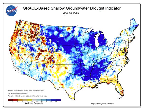
GROUNDWATER LEVELS: Since 2011, UNL's CALMIT and the National Drought Mitigation Center have worked with NASA to use GRACE to generate maps of groundwater and soil moisture conditions. These maps measure topsoil, root zone soil moisture and groundwater levels, which are used to help produce U.S. Drought Monitor maps.

Rodell explains the GRACE satellites by themselves can't distinguish changes in different layers of topsoil moisture, root zone moisture and groundwater. All water is lumped together as terrestrial water storage anomalies.
The data are integrated into a land surface model with other inputs, such as precipitation, solar radiation, topography, soil type, wind speed, temperature and humidity, and used to improve the accuracy of the model's simulation of water cycle processes, including evaporation, plant root uptake, runoff, infiltration and deep percolation. These simulations are used to create the weekly drought and wetness maps and monthly forecasts.
Benefits at the farm level
Wardlow notes GRACE tools have low spatial resolution — each grid is about 8 by 8 miles. So, it's not possible to provide updates on the current condition of a specific field. However, those tools can be used to improve the timing and accuracy for spatial boundaries of drought designations on the U.S. Drought Monitor.
"Those designations are often used as a trigger for eligibility for USDA assistance programs," Wardlow says. "Any tools that can help the Drought Monitor be more responsive or accurate where different categories start and stop are important for producers from a systems perspective."
Brian Fuchs, National Drought Mitigation Center climatologist and U.S. Drought Monitor author, notes this also can help keep track of the aquifer withdrawal across Nebraska, monitor the water balance of a given region, and enhance the Drought Monitor as an early indicator of drought.
"If the topsoil layer is dry, but you look down deeper, and there's no dry signal on the deeper layers, that's a shorter-term drought, maybe a flash drought," Fuchs says. "But as you start to see it getting drier in the deeper root zone layer, you're going to see a bigger impact to dryland crops, or you'll have to start irrigating where irrigation is available."
While the resolution isn't precise enough to see individual fields, Fuchs notes that the maps provide enough spatial coverage to see a large area, and fill in the gaps where needed.
"When I'm looking at groundwater data, it's a mix of data from different agencies in which you need to go to their web portals to find these data," Fuchs says. "In Nebraska, I may have to look at Natural Resources District data, USGS data, data from UNL or go to the Central Nebraska Public Power and Irrigation District and see their data," he says. "With GRACE, I'm still going to look at that data, but it provides a starting point where I can see groundwater levels have dropped in Nebraska, and then use the point data to get a better picture of what's going on."
About the Author(s)
You May Also Like


