

Subscribe to receive top agriculture news
Be informed daily with these free e-newsletters

Farmers are turning to eyes in the sky for more in-season information and one player is expanding
November 1, 2017
With the advent of more available aerial imagery, farmers are again considering this tool for crop management. There are a range of companies stepping in to fill that role, and one player - Ceres Imaging - is expanding its territory.
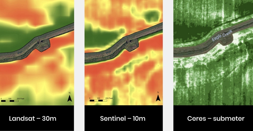
The company, which uses proprietary multi-spectral imaging to capture a range of information from each field it images, offers detailed information on water and nutrient use by a crop in-season. This is information farmer-customers can use to protect yield, or add bushels. Recently, the company announced it had received an added $2.5 million in funding from Romulus Capital, a venture capital firm.
With the added funds, the company will work to expand coverage in Australia, California and into the U.S. Midwest. The aim is to accelerate development of imagery for row crops and cereals. "We're already providing imagery for more than 10% of the tree nut crops in California," Ashwin Madgavkar told Farm Progress.
Madgavkar is CEO and founder of the company, and explained that the firm started out as a drone business, which evolved to a system using airplanes. "It's not the drone that matters it's the data and what you do with the data and the actionable decision that matters," he said.
The business has now grown to more than 40 people including scientists and engineers that work on ways to maximize the return on investment for crops it covers - including corn and soybeans. Earlier this year, Ceres Imaging partnered with The Climate Corporation to provide its imagery through the Field View platform.
Eyes in the sky
Madgavkar explained that the company has developed its own imaging sensor that captures a range of information on a single pass, but what makes the difference is the programming on the back end for putting those images to work. "We like to call it hardware-enabled software using our own sensor," he said. "We can measure water and fertilizer content at the plant level."
Since its founding in 2013, Ceres has been collecting data and through that time programmers have been refining the algorithms that help with decision making in crops. Using airplanes the company can capture detailed high-quality information multiple times in a single season to help with on-farm decision making. In addition, Ceres has worked with a range of experts in the University of California system to fine-tune its work.
The system captures multispectral imagery and then processes it to provide information for farmers. And customers find the information valuable. While the firm has received a new round of funding to help with expansion, Madgavkar said it became a profitable business in the last year. Farmers see the value in the images provide.
Water stress management is a key area where Ceres images are proving valuable. Producers can see stress areas in their fields in greater detail, which can help target irrigation more precisely. Working with tree nut producers in drought-stricken California helped get that going, but the information has value for other crops, Madgavkar explained.
For many farmers - the more detailed crop management will have more value. Madgavkar noted that with their proprietary approach, they can "see" problems earlier than may be visible to a scout in the field. That includes the potential to note disease stress far earlier for improved use of such tools as fungicides or for fertilizer side-dress applications. "We can see insect or disease stress before it appears to the human eye," Madgavkar said.
Getting planes
The question that comes up when you talk about these expanding aerial imagery businesses is this: Where are all the pilots?
Turns out, Madgavkar said that finding planes and pilots is pretty simple. "We work with companies already serving farmers, including crop dusting firms," he said. "They often have time to capture images for local farmers as part of this program."
Other potential flyers are pilots looking to add flight hours, so they can take a Cessna up with the Ceres system and capture images for customer farmers. At the same time they get flight hours, which is important to someone aiming for a commercial license.
Once the images are captured, Madgavkar said Ceres Imaging can make them available to customers within about 48 hours. Climate customers, for example, will have that information available through that platform. Or Ceres Imaging customers can get the images directly.
The company offers services across a range of image choices. "We're not a one-size-fits-all business. We are building packages around value drivers for the farmer like replant, side dress, variable rate application, pest infestation and diseases. All are slightly different, but we can customize the type of information we capture, and the frequency of when we capture images," Madgavkar said.
Pricing depends on the package and what imagery is being processed, as well as any follow-up service required for a specific customer. It can range from a few cents per acre per image to $2 per acre per image depending on what the customer wants. You can learn more at ceresimaging.net.
You May Also Like
Enter a zip code to see the weather conditions for a different location.


