

Subscribe to receive top agriculture news
Be informed daily with these free e-newsletters

Farm field walk-throughs for Root River Field to Stream Partnership help farmers fit conservation to their land.
The numbers are in, the data has been crunched and it’s time to take action.
The Root River Field to Stream Partnership, led by Minnesota Department of Agriculture staff in Preston, is beginning phase two of its program. That involves working one-on-one with local farmers to consider adding conservation practices to critical areas and in portions of fields that might need some practices tweaked to perform better. Fifty-two of the 53 farmers in the program area, representing 8,400 crop acres, have had field walkovers.

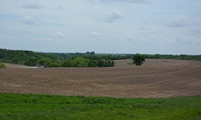
Looks deceiving. The Field to Stream cooperator that owns this field worked with the Houston County SWCD and other agencies and decided it was time to enroll it in CRP and plant it to pollinator habitat. That will happen after this growing season. The field has challenging slopes ranging from 10% to 14% that direct flow into ravines that go directly to Bridge Creek. This field was considered to be one of the highest runoff risks in the watershed, using conservation planning tools developed by USDA’s Agricultural Research Service and used by MDA. New grass waterways will be shaped and new water and sediment control structures will be installed this fall so the field will be ready for production after it comes out of CRP.
Phase one, which began in spring 2010 with edge-of-field and in-stream monitoring, involved collecting data in three subwatersheds of the Root River: the south branch of the Root River headwaters, Crystal Creek and Bridge Creek.
The partnership came together eight years ago in an effort to answer questions about how farming practices affect the health of local rivers and streams in a watershed. The Root River watershed was chosen for its diversity—glacial till, karst topography and bluff land.
You learned about the project yesterday on this website. Here are more details and photos about it.

Trying different fertilizer rates and timing. On the monitored 60-acre tiled field of Wayne DeWall, Grand Meadow, Field to Stream staff, in collaboration with CHS of Grand Meadow and funding from Minnesota Corn Growers, are monitoring various levels of nitrogen fertilizer to see if overall nitrate levels leaving the field will decrease. During the wet growing season of 2013, nearly 50 pounds per acre of nitrate-nitrogen was lost from the tile monitoring station. In a normal year, that amount would be closer to 30 pounds. The goal? To see if it is possible to reduce long-term N losses in DeWall’s tile water by 20% through nitrogen application rate adjustment and split applications—all while maintaining yields and lowering input costs. “I am learning that we can apply less, maybe 10% to 30% less, and still get really good yields,” DeWall says. He appreciates being involved on the ground floor of watershed research. “We’re already proving it’s not as bad as some think,” he adds. To further reduce water pollution, DeWall may install edge of field grass strips to trap sediment and associated nutrients leaving his field in surface runoff.

Good-bye gully. This 26-acre field, planted to continuous corn grain and silage at Johnson Rolling Acres farm near Rushford, saw some serious erosion in 2013 and 2014 following heavy rains. The field averaged 24 pounds per acre soil loss before a gully formed along the outside edge of an existing grass waterway. After the gully formed, losses averaged more than 5,000 pounds per acre and highlighted the importance of maintaining existing conservation practices. This site emphasized the importance of grassed waterways in concentrated flow areas and is why the partnership has focused so much time on this particular practice, explains Kevin Kuehner, MDA. The field walkover process found that more than 30% of the existing grass waterways in the study watersheds had similar gully features to the one that is being monitoring here. Owner Richard Johnson invested his own money into this grassed waterway that he had rehabilitated last fall. He also had another 6,000 feet of waterways built in other fields on his farm. Monitoring will continue for the next four years to measure the effectiveness of the new waterway.

Watershed outlet monitoring. Drainage to the Bridge Creek watershed outlet is 4,665 acres. The monitoring station is located on a productive trout stream near Houston. Producers have installed many practices on their own with 42 water/sediment storage structures and 16 miles of grass waterways. With the rolling topography, sediment control basins are very popular but many are more than 50 years old. Other water quality challenge in this watershed include high sediment and P concentrations during storm events and there has been a 35% decrease in contour strip farming since 1991. Goals for new conservation include rehabilitating about one-third of those existing waterways and structures and adding 10 miles of new waterways and 10 new water/sediment structures.
You May Also Like
Enter a zip code to see the weather conditions for a different location.


