Subscribe to receive top agriculture news
Be informed daily with these free e-newsletters

Army Corps of Engineers watch Mississippi River crest forecasts to stay ahead of high water
January 5, 2016
Almost 300 U.S. Army Corps of Engineers personnel from throughout the Mississippi Valley Division are continuing to combat flooding from high Mississippi River levels as the river crested Jan. 3 at 56 feet on the Cairo gage.
Related: Flooding causes headache for farmers in Midwest
As record-breaking river levels recede on the upper Mississippi and its tributaries, continue to watch for trouble spots.

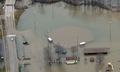
A residential park area is overtaken by flood water from the Meremac River on December 31, 2015, in Eureka, Missouri. (Photo by Michael B. Thomas/Getty Images)
"We are working as a regional team to fight this flooding," said Maj. Gen. Mike Wehr, Mississippi Valley Division commander. "The amount of coordination and collaboration with other federal and state agencies, our fellow Corps divisions and with local communities, has been incredibly important to the success of this flood fight. Our hearts and prayers go out to everyone suffering from the impacts of the heavy rains and flooding within Missouri, and we will do everything we can to prevent further flooding as the crest moves south."
Memphis District U.S. Army Corps of Engineers announced Jan. 2 that based on the lowered crest and forecast for the Ohio River at Cairo, Ill., all preparatory actions for operation of the Birds Point-New Madrid floodway have been put on hold.
"While the decision to hold off loading the barges, and then moving the barges upriver, does mean we will not currently operate the floodway, it doesn't mean we're completely out of the woods," said Colonel Jeff Anderson, commander of the Memphis District. "While this ends planning and preparation for this event, we must remain vigilant for any other events that may happen this flood season. There's still a lot of water in the system that's making its way to the Gulf of Mexico and we must be prepared for future rain events within the massive Mississippi River drainage basin."
Related: Farmers ring in 2016 with high water woes
The National Weather Service's forecast called for the Mississippi River at New Madrid, Mo., to crest at 44.0 feet Tuesday. The Vicksburg and New Orleans district offices continue to stay in close coordination with the NWS to stay ahead of high water.
Flood stage in Vicksburg is 43 feet and current predictions from the National Weather Service take the river at Vicksburg to 52.5 feet on Jan.15. Flood stage in New Orleans is 17.0 feet and current NWS predictions have forecast the river to crest at 17.0 feet on Jan. 9.
~~~PAGE_BREAK_HERE~~~
Preparations underway downriver
As river levels increase downriver, the Corps and its partners are engaged in a proactive flood fight along the Mississippi and Atchafalaya rivers. During this flood fight, the Corps and local levee districts have team members on the ground monitoring and conducting inspections so that any potential threats to the integrity of the levee system can be quickly addressed.
"Strong coordination and communication between partners are integral parts of our ability to safely pass this high water," said Col. Richard Hansen, commander of the New Orleans District. "In South Louisiana, we have a robust, well-prepared and experienced team of local, state and federal emergency responders whose top priority is the safety of the public."
Current NWS forecasts indicate that the Mississippi River could reach the project-design flow of 1.25 million cubic feet per second, coinciding with a 17-foot stage, in the greater New Orleans area. If this flow occurs, the Corps has the capability to regulate the amount of water flowing through the city by operating the Bonnet Carre' Spillway to safely divert up to 250,000 cfs of water into Lake Pontchartrain.
Upriver from Baton Rouge, the Morganza floodway control structure could be operated if river levels reach 57 feet at the structure and there is a 10-day forecast indicating a Mississippi River flow of 1.5 million cubic feet per second and rising past the structure. The structure would be operated to maintain a water stage of 57 feet on the river side of the structure, and a Mississippi River discharge rate that does not exceed 1.5 million cubic feet per second below the floodway.
The Mississippi River &Tributaries project is being operated, and is performing, as designed. It is one of the world's most comprehensive and successful flood control and navigation systems and has provided unprecedented protection during two severe floods in the past five years. Because of the MR&T project below Cairo, extensive flooding in protected areas was avoided during the Great Flood of 2011, with more than $230 billion in damages prevented. Additionally, no lives were lost due to the floods in 2011. The system did suffer approximately $2 billion in damages, with $1.5 billion invested in repairs, to date.
The investment in repairs and improvements are being tested by the current flood and the MR&T remains incomplete (currently 87% complete). This is an important consideration given the system was just one large storm event away from potentially reaching the project design flood capacity.
Day-to-day oversight and coordination of the Mississippi River's flow and its watershed are the responsibility of the Mississippi Valley Division's Watershed Division. Division hydrologists and hydraulic engineers keep track of river stages in real time using satellite links to gages and coordinate closely with multiple organizations, including the National Weather Service, to provide an ongoing picture of current and expected river conditions.
The Corps continues implementing a watershed-wide plan to reduce outflows from reservoirs located on the system. Reservoirs within the Mississippi Valley Division and the Great Lakes and Ohio River Division have been instrumental in keeping the crest at Cairo from reaching higher levels, adding more confidence to the ongoing flood fight. All Corps reservoirs with the ability to impact Mississippi River flood stages are currently evaluating water releases to help reduce stage levels and minimize impacts to communities along the river.
Source: Army Corps of Engineers
You May Also Like
Enter a zip code to see the weather conditions for a different location.


