Subscribe to receive top agriculture news
Be informed daily with these free e-newsletters

In the hands of an experienced operator an unmanned aerial system can offer you added insight into your operation.
UAVs in the hands of a trained agronomist or skilled farmer are more than toys. They’re becoming an important tool in getting a bird’s-eye view when a 400-foot ladder isn’t an option.
Dennis Bowman, an Extension agronomist with the University of Illinois, tested various unmanned aerial vehicles over the past four years. Reduce your learning curve by taking advantage of his observations.

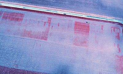
RED ALERT: It’s easy to see where Palmer amaranth was heaviest in this infrared image. Note the reddish patches near the top.
The first step is knowing why you want a UAV, he says. That helps nail down the type of UAV and price range. The UAV field is still a bit of a Wild West frontier, with companies popping up and some fading out. You can find everything from $300 models to $50,000 systems. Many are multi-rotors. Others are fixed-wing, airplane designs.
“There are trade-offs to both,” Bowman says. “The choice will likely come down to what you’re trying to accomplish.”
Multi-rotor UAVs tend to be more stable in flight and are typically easier to learn to fly, he notes. “You can also take off in a small space without problems,” he adds. “But they tend to be limited on flight time. You may charge batteries for 90 minutes to get 15 minutes in the air.”
Fixed-wing UAVs can carry bigger payloads, Bowman says. Adding heavier payloads to a multi-rotor machine cuts flight time even more. “But fixed-wing crafts need more space to launch,” he says. “If you’re working around trees and power lines, that’s an issue. I’ve even seen one that requires a rail-type catapult to launch it.”
More uses
The longer Bowman experiments with UAVs, the more uses he finds. Here are some examples he offers:

MYSTERY SOLVED: A town ran street lights into the country, and soybeans didn’t mature properly. The UAV image convinced city officials to act. Shutting off lights on weekends helped.
Traditional crop scouting. With either a rotor or fixed wing, get images that can help pinpoint where you might have problems, and where you should walk and look. With some machines, you can watch the flight live. There are options that allow you to stitch together an image the same day, either on your own software or by sending it to a third party. Turnaround time and convenience become considerations, he says.
Infrared images. Infrared photography can produce normalized difference vegetation index (NDVI) images that allow you to see concentrations of weeds quickly, he says. You’ll see more intense color where weed patches are thick.
High-resolution images. If you want to get down close and personal with plants, you can, Bowman says. It’s a matter of how you fly and the camera equipment that you select.
Investigate unusual situations. Sometimes answers are hard to find at eye level. If you can get a view from above, patterns become more obvious, Bowman says. He’s been asked to solve unusual crop mysteries by getting a higher view.

CLOSE VIEW: Here’s a view from one of Dennis Bowman’s UAV cameras that shows individual plants in plots.
Records and planning. Where drainage ditches form networks and are essential to farming, get a more complete picture of how ditches tie together from the air. File this image for future reference.
What FAA rules may look like
Agronomist Dennis Bowman is getting a better handle on what the final rule for using UAVs in agriculture may look like. There’s no definite word on when the Federal Aviation Administration may release it.
Here are key points:
* UAVs will be classified by size. There will be categories for those under 55 pounds, those under 4 pounds and those under a half pound.
* The maximum flying height could be 500 feet. Most have been staying at 400 feet or less.
* Commercial operators can only fly one UAV at a time. An agronomist can’t send up two or three at once.
* Registration will be required. Numbers will be issued by the FAA for your UAV.
* A license will be required. Timeline on this one may be pushed back, Bowman says.
Ask these10 questions before buying
* Here are 10 questions Dennis Bowman would ask before buying a UAV.
* How much range does it have?
* What is the expected flight time, and what impacts it?
* Is GPS built in?
* Will it work off both GLONASS and U.S. GPS?
* How easy is it to learn to use?
* What kind of support system is available? Is it easy to access?
* Is it compatible with other products?
* Is it upgradable?
* Can you get “real-time” results?
* Does it have proven capabilities? Can you talk to other users?
Decision Time: Production is independently produced by Penton Agriculture and brought to you through the support of Case IH. For more information, visit farmprogress.com/decisiontime.
You May Also Like
Enter a zip code to see the weather conditions for a different location.


