Subscribe to receive top agriculture news
Be informed daily with these free e-newsletters

U.S. Drought Monitor reports some measurable dryness across Midwest as showers have been spotty in areas
August 21, 2014
A variable weather pattern across the Midwest and minimal rains in the West have resulted in relatively few drought condition changes on the U.S. Drought Monitor this week, though a large section of D0 has popped up in Iowa and across the Indiana-Ohio line.
Mixed conditions dotted Texas, as usual, prompting some degradation and some improvement. In the far west, drought continues its persistence.

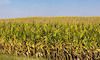
U.S. Drought Monitor reports some measureable dryness across Midwest as showers have been spotty in areas; Corn crops in the Midwest continue to progress.
Midwest, Ohio Valley
Moderate to heavy rains doused part of the lower Ohio Valley and upper Tennessee Valley. Otherwise, this was a relatively dry week, with little or no precipitation reported north of the Ohio River, says Drought Map author Richard Tinker of the National Oceanic and Atmospheric Administration.
There were small-scale reductions in D0 and D1 coverage in the region of heavier rainfall, but most places remained the same or deteriorated. D0 was introduced across a large part of eastern Indiana, southwestern Ohio, and northernmost Kentucky, where only about half of normal rainfall was measured in the last 30 days, he said.
Also, 90-day totals were only 70 to locally less than 50% of normal in eastern Indiana. Low soil moisture and groundwater – among the lowest 5% for this time of year – is affecting the regions.
The Southeast
Sub-normal precipitation affected almost this entire region, with a few scattered exceptions, Tinker said. Abnormal dryness was removed from small parts of North Carolina because of the recent rains and a lack of significant impacts. In contrast, growing moisture deficits led to the expansion of D0 and D1 conditions across southern Georgia and part of adjacent Florida.
Western Great Lakes, Plains
It was a typical summer week in the Western Great Lakes and Plains region as a whole, Tinker reports, with a highly variable rainfall pattern observed.
More than 3 inches of rain was reported from south-central Iowa and adjacent Missouri southeastward into southern Illinois, with 5 or more inches soaking parts of northern Missouri.
Parts of Wisconsin, southeastern Minnesota and North Dakota, and a few spots in central and northeastern Texas also saw rain. Most other locations received somewhere between a few tenths of and 2 inches of rain, prompting some improvement in Oklahoma and Texas.
Growing short-term moisture deficits also prompted the expansion of D0 southward into broader regions of southern Missouri.
Crop conditions in the region continue to be favorable as the largest spring wheat producing state in the U.S., North Dakota, saw wheat ratings of 73% good to excellent in USDA's Monday update.
Top corn and soy producer Iowa saw corn slip to 75% good to excellent from 76% while soybeans dropped to 73% from 75%.
~~~PAGE_BREAK_HERE~~~
The Rockies and West
Heavy monsoonal rains were reported through parts of southern and western New Mexico, central and eastern Arizona, southern Utah, and part of eastern Nevada.
Intense rainfall led to serious flash flooding north of Phoenix, Ariz., but did not fall within the Drought Monitor period. Nonetheless, improvements to D2 were introduced in part of central Arizona where the heavier rain fell.
Elsewhere, moderate rains of one-half to 2 inches fell on part of the northern Intermountain West and part of the northern Rockies, but drought conditions remained unchanged outside Arizona and New Mexico.
Seasonably dry conditions kept drought conditions unchanged in the far West, but unusual rainfall did lead to two areas of improvement in southwestern Oregon and the deserts of southeastern California.

Source: U.S. Drought Monitor/Richard Tinker
You May Also Like
Enter a zip code to see the weather conditions for a different location.


