Subscribe to receive top agriculture news
Be informed daily with these free e-newsletters

Like a stubborn relative putting down roots in your guest room, El Nino is expected to hang around through April and even into May.Will continue to result in a wet winter, which is the last thing farmers in the region need.
February 29, 2016
One of the most powerful El Ninos ever recorded is finally starting to relinquish its grip, but South Carolina’s beleaguered farmers might not see any significant relief from relentless rains until April.
The 2015-16 El Nino — which rivaled and possibly surpassed similar events in 1982-83 and 1997-98 — will fade sometime this spring. Even so, it hasn’t finished causing problems just yet.
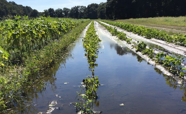
“Growers can’t even get in and finish destroying last year’s crop,” said David DeWitt, Clemson Extension’s area row crop agent for Lee, Sumter and Kershaw counties. “Because the rains still haven’t stopped, the growers are just sitting there staring at their fields. They can’t repair ruts made in the fall, and they can’t put down fertilizer and lime like they normally do in January and February. Everything’s just kind of on hold.”
So if 2016 is off to a shaky start, especially for crops such as wheat and corn, then what’s in store for growers the rest of the year?
“In the counties I work, there were less than a thousand acres of wheat planted in each county, and they normally plant 7,000 to 10,000 or more,” DeWitt said. “In the middle of March, farmers start planting corn and they’d be behind schedule even if it stopped raining today. But if the rains do stop, growers will at least have the opportunity to catch back up. And if there is a drying-out period followed by timely rains that are not excessive through September, then there’s still a good chance for a strong rebound, especially for cotton, soybeans, peanuts and grain sorghum.”
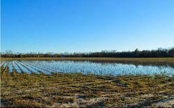
A field still saturated in mid-February 2016.Jonathan Windham / Clemson University
The good news is that many climate experts are hopeful that the rest of 2016 in South Carolina will be a better year, weather-wise, than its ugly and destructive predecessor. Of course, it would be difficult for this year to be any worse than 2015.
There are several reasons to feel more positive. First, the El Nino that disrupted weather patterns in many parts of the world – and especially in the Southeastern U.S. – reached its peak in November and has been in decline ever since.
However, like a stubborn relative putting down roots in your guest room, El Nino is expected to hang around through April and even into May. This will continue to result in a wet winter, which is the last thing farmers in the region need. Regardless of how long it takes to dissipate, the El Nino will start to lose its impact on weather and climate patterns in April, which is normally one of the driest months of the year in the Southeast.
El Nino is an unusual warming of the tropical waters of the equatorial Pacific, reaching from the west coast of South America to the International Date Line. Every two to seven years, this huge expanse of ocean surface water becomes warmer than normal, creating a vast source of heat and moisture for the middle and upper atmosphere that tends to modulate the jetstream patterns over North America. In 2015, the water got especially hot, as much as 10 degrees higher than usual, surpassing 80 degrees.
“We are in the midst of one of the strongest El Ninos we’ve experienced over the past 65 years,” said David Zierden, state climatologist for Florida who is based at Florida State University in Tallahassee. “This favors a much stronger and more active subtropical jetstream that tends to meander over the southern tier of the United States. Storms form on this subtropical jet and first impact California. Then they frequently move along and eventually draw moisture from the Gulf of Mexico, re-energizing along the southeast Atlantic coast and causing frequent low-pressure systems and rainy and stormy spells in the Southeast. We get winter low-pressure systems nearly twice as often when we’re in the El Nino pattern than during normal years.”
So when the 2015-16 El Nino finally goes away, what will happen next? Climatologists say that El Ninos virtually never occur in successive years, so at least that’s not an issue. But two weather patterns are waiting in the wings. The El Nino could fade into a “neutral” period. Or it could immediately be replaced by a La Nina, which is El Nino’s counterpart. During La Ninas, the same surface water in the Pacific becomes cooler than normal, which results in warmer, drier winters in South Carolina and the rest of the Southeast.
However, neither El Ninos nor La Ninas have much of an effect on summer weather patterns in South Carolina. Instead, a phenomenon called the Bermuda High takes precedence from June-August. The Bermuda High is an area of high pressure in the Atlantic Ocean that is a large-scale contributor to weather patterns up and down the east coast of the U.S. The position and strength of the Bermuda High plays a substantial role in whether the Southeast gets a moist return flow out of the tropics and the Gulf. If it is positioned too far to the west, it can lead to a hot, dry summer in South Carolina.
“Our predictability for summer is always limited because it’s highly driven by the position of the Bermuda High,” said Hope Mizzell, state climatologist for the S.C. Department of Natural Resources. “We are not able to forecast the influence of the Bermuda High beyond a couple of weeks.”
Mizzell did say, however, that “neutral” or La Nina conditions will likely result in a warmer and, thankfully, drier late fall and winter. This would be excellent news for those who harvest later in the year. Regardless, South Carolina growers remain nervous, both about the weather and also about commodity prices that are disturbingly low for many crops.
“There’s not much for growers to get excited about right now,” DeWitt said. “The only way they can make money when commodity prices are low is to have an above-average yield, and they can only have an above-average yield if conditions are good. So these kinds of things make everybody anxious.”
“I’ve been talking to growers all over the state,” said Clemson scientist Brian Ward, who is a research specialist at Coastal Research and Education Center in Charleston, “and they’re all saying the same thing: ‘Please, stop raining!’ ”
You May Also Like
Enter a zip code to see the weather conditions for a different location.


