Subscribe to receive top agriculture news
Be informed daily with these free e-newsletters

SPONSORED: A significant amount of attention is given to farm drones, and for good reason. Drones are a perfect example of how precision agriculture advancements are increasing efficiencies for growers, implement manufacturers, crop consultants, and seed dealers; allowing them to collect massive amounts of aerial data from a unique vantage point.
February 2, 2016
Sponsored Content
A significant amount of attention is given to farm drones, and for good reason. Drones are a perfect example of how precision agriculture advancements are increasing efficiencies for growers, implement manufacturers, crop consultants, and seed dealers; allowing them to collect massive amounts of aerial data from a unique vantage point.
The significance of this new technology goes beyond the drone, even beyond the highly sophisticated sensors riding on the drone. The power of a farm drone is only realized when the plethora of precise crop health images are organized, stored, managed, and ultimately leveraged to produce value for the grower.
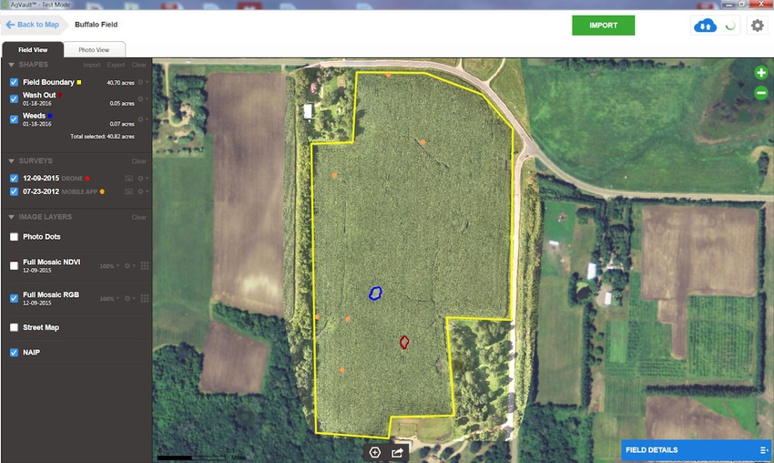
Sentera, LLC, a software, sensor, and drone company saw drone-users struggling to manage the volume of data captured during drone flights. In direct response to this need, Sentera developed the AgVault™ Software solution and mobile application, an automated, intuitive, and easy way manage and leverage drone-captured crop health data.
In a single flight, a farm drone can collect thousands of images that range from high-resolution RGB, near-infrared (NIR), and normalized difference vegetation index (NDVI) imagery. Without a robust data management solution in place, the sheer volume of data can inhibit farmers from fully leveraging the crop health intelligence they are seeking.
“AgVault is designed to help any farmer, agronomist, consultant, or adviser increase their operational efficiency by streamlining how imagery is utilized,” said Kris Poulson, vice president of agriculture for Sentera. “AgVault provides users with a simple way to view layers of complex data while optimizing existing tools and resources.”
In moments, new images are organized geographically and assigned to the correct field on a map, represented by a pin. AgVault allows users to quickly identify a problem area and magnify a point of interest on the map to view plant-specific photos and address areas of concern in real-time.
Poulson continued, “Because AgVault functions independent of an internet connection, users can access crop health data and create a QuickTile™ map immediately after a drone lands, while still in the field. This feature allows growers to save time and make irrigation, fertilizer, herbicide, or pesticide decisions during a potentially critical input-window, using up-to-the-minute information.”
Growers, consultants, and advisors can have a dynamic, interdependent relationship where instant input is needed to ensure a crop is properly diagnosed, and prescriptive treatments commence. AgVault allows users to annotate and share a single image, export an entire data collection or give access to an entire farming operation ensuring advisors can instantly see exactly what is happening at a grower’s farm. Sharing images allow trusted consultants to cover more acres, better, and faster.
“Once data is loaded into AgVault, users can prepare and format data for export into common stitching tools including Pix4D, Agisoft, and Autopano Giga,” said Poulson. “Additionally, data is compatible with existing agriculture data analytic software tools including MyJohnDeere Operation Center, APEX, SST, SMS, and Farm Works Software.”
AgVault mobile allows users to capture geo-tagged, ground-based imagery using any mobile device. The desktop client and mobile app sync instantly ensuring users have a complete picture of a crop’s health.
The software is sensor, drone, and implement agnostic and is compatible with the most popular prescriptive data analytic tools. All imagery is saved to a secure, 256-bit AES + SSL encrypted cloud server, and, once uploaded, is available instantly anywhere in the world.
Sentera’s AgVault Software is available today with a free trial. Visit www.sentera.com/agvault to learn more and sign up for the offer.
You May Also Like
Enter a zip code to see the weather conditions for a different location.


